From Surf Wiki (app.surf) — the open knowledge base
Bassenthwaite Lake
Large lake in the United Kingdom
Large lake in the United Kingdom
| Field | Value |
|---|---|
| name | Bassenthwaite Lake |
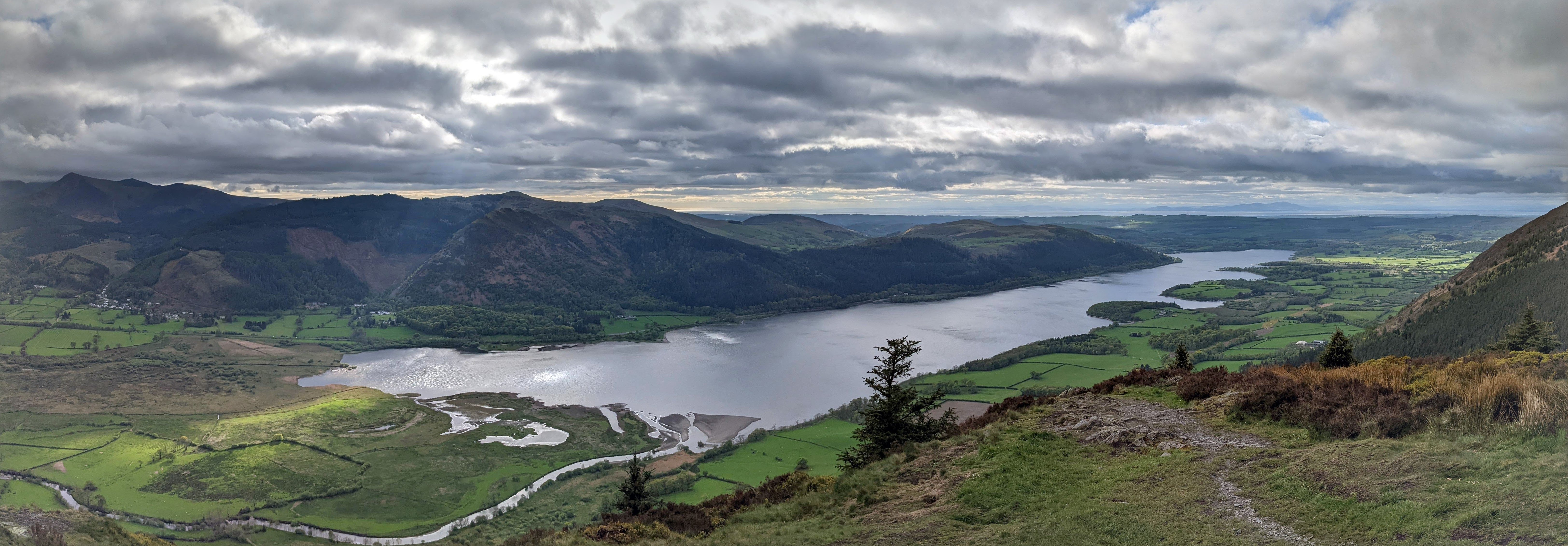
| image | Bassenthwaite Lake.jpg |
| caption | View from Blackstock Point |
| image_bathymetry | Bassenthwaite Lakecrop.jpg |
| caption_bathymetry | Map (1925) |
| pushpin_map | United Kingdom Lake District#United Kingdom Allerdale |
| pushpin_map_caption | Location in the Lake District National Park##Location in Allerdale, Cumbria |
| location | Lake District |
| coords | |
| inflow | River Derwent |
| Newlands Beck | |
| outflow | River Derwent |
| catchment | 96.5 sqmi |
| basin_countries | United Kingdom |
| length | 4 mi |
| width | 0.8 mi |
| area | 1.98 sqmi |
| max-depth | 70 ft |
| shore | 11.3 mi |
| elevation | 223 ft |
| islands | 0 |
Newlands Beck | max-depth = 70 ft

Bassenthwaite Lake is a body of water in the Lake District in North West England, near the town of Keswick. It has an area of 5.3 km2, making the fourth largest of the lakes in the region. The lake has a length of approximately 4 mi long and maximum width of 0.75 mi, a maximum depth of 19 m, and a surface elevation of 68 m above sea level. Its primary inflow and outflow is the River Derwent, which drains into the Irish Sea at Workington. The lake is in the unitary authority of Cumberland, and the ceremonial county of Cumbria.
Bassenthwaite Lake is the only body of water in the Lake District to use the word 'lake' in its name, all the others using the local terms 'water' (e.g. Derwentwater), 'mere' (e.g. Windermere) or *'''tarn' (e.g. Dock Tarn). Some maps dating from the 18th century do in fact mark this lake with the name Bassenwater, and the use of the name *Broadwater'' for this lake is also attested.
The A66 dual carriageway runs roughly north–south along the western side of the lake. The lay-bys are popular spots for photographers and bird watchers looking for osprey. The section running south towards Keswick was built along the course of the former Cockermouth, Keswick and Penrith railway line.
Origin
Like the other Lake District lakes, Bassenthwaite Lake lies in a glacially eroded valley, left after the last glaciation. Bassenthwaite Lake is linked to Derwent Water by the River Derwent, which crosses the 3 mi alluvial plain between the two lakes. There has been speculation that Derwent Water and Bassenthwaite Lake were once one larger lake with the alluvial flats now separating them formed from partial infill of the original basin.
Toponymy
The lake takes its name from the village of Bassenthwaite, meaning "Bastun's clearing". Bastun is usually taken to be an Anglo-French nickname or surname originally meaning "stick", while thwaite is from Old Norse þveit ("clearing"). The lake was also formerly known as Bastun's water.
Biodiversity
The lake's catchment is the largest of any lake in the Lake District. This, along with a large percentage of cultivable land within this drainage area, makes Bassenthwaite Lake a fertile habitat.
The lake contains salmon, trout, pike, perch, minnow, dace, ruffe and eel, though the predominant species is roach. Also present was the vendace, until it was declared extinct within the lake in 2001.
Birdlife
Cormorants have been known to fish the lake and herons can also be seen; at the turn of the 19th century there was a report of 60 nests in a heronry in nearby Wythop Woods.
Lake District Osprey Project
In 2001, ospreys returned to nest in the Lake District after more than a hundred years. They nested by the lake, and have done so regularly since. The osprey family can be watched from viewpoints at Dodd Wood and by CCTV from Whinlatter Forest Visitor Centre.
Threats
Water quality is adversely affected by high sediment deposition, and there are other problems such as phosphate pollution. These issues are being addressed via the Bassenthwaite Lake Restoration Programme. To reduce the sediment entering the lake more trees have been planted alongside watercourses, and clear felling of existing tree cover has been discouraged with the cooperation of Forestry England.
Phosphates encourage algae formation. The Environment Agency attributed unacceptable levels of phosphate in the catchment to Keswick wastewater treatment works, Greta Grove pumping station and the associated overflow. Water company United Utilities was fined £27,000 in 2011 for allowing raw sewage to pollute nearby Pow Beck watercourse. The company's £20 million sewer improvement scheme, begun in 2011, aims to improve water quality in the River Greta and the lake itself. The project will facilitate removal of greater quantities of phosphates. Works to upgrade the wastewater treatment works and pumping station were begun in May 2010.
Neolithic era
It has been reported that the wide gravel spreads between Derwent Water and Bassenthwaite Lake provided the best centre within Lakeland for Neolithic farming communities. Stone axes have been found in the area and particularly at Mossgarth, Portinscale.
References
Sources
- A Topographical Dictionary of England (1848)
References
- "Lakes - treating the land to fix the water". nationalparks.gov.uk.
- Whaley, Diana. (2006). "A dictionary of Lake District place-names". English Place-Name Society.
- [http://www.ospreywatch.co.uk/ Ospreywatch], Lake District Osprey Project
- Lewes, Martin. (17 May 2010). "Progress in campaign to reduce Lake District pollution". [[BBC News]].
- (December 2009). "River Basin Management Plan North West River Basin District". [[Environment Agency]].
- (August 2025). "Wastewater scheme will help restore lake". [[Cumberland and Westmorland Herald]].
- (25 November 2011). "United Utilities fined £27,000 for Keswick sewage leaks". [[BBC News]].
- (October 2016). "Keswick project overview". [[United Utilities]].
- (19 September 2011). "Keswick's £23m sewer revamp gets under way". [[BBC News]].
- (26 August 2011). "£20m Keswick pollution project to benefit lake". Cumberland News.
This article was imported from Wikipedia and is available under the Creative Commons Attribution-ShareAlike 4.0 License. Content has been adapted to SurfDoc format. Original contributors can be found on the article history page.
Ask Mako anything about Bassenthwaite Lake — get instant answers, deeper analysis, and related topics.
Research with MakoFree with your Surf account
Create a free account to save articles, ask Mako questions, and organize your research.
Sign up freeThis content may have been generated or modified by AI. CloudSurf Software LLC is not responsible for the accuracy, completeness, or reliability of AI-generated content. Always verify important information from primary sources.
Report