From Surf Wiki (app.surf) — the open knowledge base
Barisan Mountains
Mountain range in Sumatra, Indonesia
Mountain range in Sumatra, Indonesia
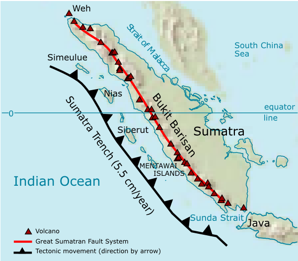
The Bukit Barisan or the Barisan Mountains are a mountain range on the western side of Sumatra, Indonesia, covering nearly 1,700 km (1,050 mi) from the north to the south of the island. The Bukit Barisan range consists primarily of volcanoes shrouded in dense jungle cover, including Sumatran tropical pine forests on the higher slopes. The highest peak of the range is Mount Kerinci at 3,800 metres (12,467 ft). The Bukit Barisan Selatan National Park is situated towards the southern end of the range in Liwa, Indonesia.
The name Bukit Barisan actually means "row of hills" or "hills that make a row" in Malay, for the range stretches end to end along the island of Sumatra.
There are 35 active volcanoes in Bukit Barisan. The largest is the supervolcano Toba within the 100 km (62 miles) × 30 km (19 miles) Lake Toba, which was created after a caldera collapse (est. in 74,000 Before Present). The eruption is estimated to have been at level eight on the VEI scale, the largest possible for a volcanic eruption.
List of volcanoes
The following list of active volcanoes in Bukit Barisan is sourced from the Smithsonian Institution's Global Volcanism Program.
| Name | Shape | Elevation | Last eruption (VEI) | Geolocation |
|---|---|---|---|---|
| Weh | stratovolcano | 617 | Pleistocene | |
| Seulawah Agam | stratovolcano | 1,810 | (2) | |
| Peuet Sague | complex volcano | 2,801 | (2) | |
| Geureudong | stratovolcano | 2,885 | ||
| Mount Leuser | non-volcanic | 3,466 | ||
| Kembar | shield volcano | 2,245 | Pleistocene |
|- | Sibayak || stratovolcano || align="right"| 2,212 || || |- | Sinabung || stratovolcano || align="right"| 2,460 || 2 March 2021|| |- | Toba || supervolcano || align="right"| 2,157 || cca 75.000 years ago || |- | Helatoba-Tarutung || fumarole field || align="right"| 1,100 || Pleistocene || |- | Imun || unknown || align="right"| 1,505 || unknown || |- | Sibualbuali || stratovolcano || align="right"| 1,819 || unknown || |- | Lubukraya || stratovolcano || align="right"| 1,862 || unknown || |- | Sorikmarapi || stratovolcano || align="right"| 2,145 || (1) || |- | Talakmau || complex volcano || align="right"| 2,919 || unknown || |- | Sarik-Gajah || volcanic cone || align="right"|unknown || unknown || |- | Marapi || complex volcano || align="right"| 2,891 || (2) || |- | Tandikat || stratovolcano || align="right"| 2,438 || (1) || |- | Talang || stratovolcano || align="right"| 2,597 || (2) || |- | Kerinci || stratovolcano || align="right"| 3,800 || (2) || |- | Hutapanjang || stratovolcano || align="right"| 2,021 || unknown || |- | Sumbing || stratovolcano || align="right"| 2,507 || (2) || |- | Kunyit || stratovolcano || align="right"| 2,151 || unknown || |- | Pendan || unknown || align="right"|unknown || unknown || |- | Belirang-Beriti || compound || align="right"| 1,958 || unknown || |- | Bukit Daun || stratovolcano || align="right"| 2,467 || unknown || |- | Kaba || stratovolcano || align="right"| 1,952 || (1) || |- | Dempo || stratovolcano || align="right"| 3,173 || (1) || |- | Patah || unknown || align="right"| 2,817 || unknown || |- | Bukit Lumut Balai || stratovolcano || align="right"| 2,055 || unknown || |- | Besar || stratovolcano || align="right"| 1,899 || (1) || |- | Suoh || caldera || align="right"| 1,000 || (4) || |- | Hulubelu || caldera || align="right"| 1,040 || || |- | Rajabasa || stratovolcano || align="right"| 1,281 || || |}
Inactive volcanoes
The following list is sourced from the Study Archaeology
| Name | Shape | Elevation | Last eruption (VEI) | Geolocation |
|---|---|---|---|---|
| Mount Pesagi | caldera | 3,262 | unknown | |
| Sekincau Belirang | caldera | 1,719 | unknown | |
| Ranau | caldera | 1,881 | unknown |
|File:Toba_zoom.jpg |Landsat image of Lake Toba
|File:Monte Marapi.JPG |Marapi
References
References
- "Travelling in Indonesia".
- {{cite gvp
- Oppenheimer, C.. (2002). "Limited global change due to the largest known Quaternary eruption, Toba ≈74 kyr BP?". Quaternary Science Reviews.
- "Volcanoes of Indonesia - Sumatra". [[Smithsonian Institution]].
- "Global Volcanism Program {{!}} Sinabung".
- (20 February 2020). "Gunung Pesagi, Atapnya Lampung Indahnya Kebangetan - Gunung".
This article was imported from Wikipedia and is available under the Creative Commons Attribution-ShareAlike 4.0 License. Content has been adapted to SurfDoc format. Original contributors can be found on the article history page.
Ask Mako anything about Barisan Mountains — get instant answers, deeper analysis, and related topics.
Research with MakoFree with your Surf account
Create a free account to save articles, ask Mako questions, and organize your research.
Sign up freeThis content may have been generated or modified by AI. CloudSurf Software LLC is not responsible for the accuracy, completeness, or reliability of AI-generated content. Always verify important information from primary sources.
Report