From Surf Wiki (app.surf) — the open knowledge base
Baranya County (former)
County of the Kingdom of Hungary
County of the Kingdom of Hungary
| Field | Value |
|---|---|
| native_name | |
| conventional_long_name | Baranya County |
| common_name | Baranya |
| subdivision | County |
| nation | the Kingdom of Hungary |
| (1000-1541, 1699-1946) | |
| year_start | 1000 |
| event1 | Ottoman conquest |
| date_event1 | 1541 |
| event2 | County recreated |
| date_event2 | 1699 |
| event3 | Treaty of Trianon |
| date_event3 | 4 June 1920 |
| event4 | Recover remaining parts of Baranya County |
| date_event4 | 11 April 1941 |
| event5 | Monarchy abolished |
| date_event5 | 1 February 1946 |
| image_coat | Coa_Hungary_County_Baranya_(history).svg |
| image_map | Baranya vármegye Magyarországon.svg |
| capital | Pécs |
| coordinates | |
| stat_area1 | 5176 |
| stat_pop1 | 352478 |
| stat_year1 | 1910 |
| stat_area2 | 4033 |
| stat_pop2 | 311660 |
| stat_year2 | 1930 |
(1000-1541, 1699-1946) Hungary (4,033 km2)
Croatia (1,143 km2)

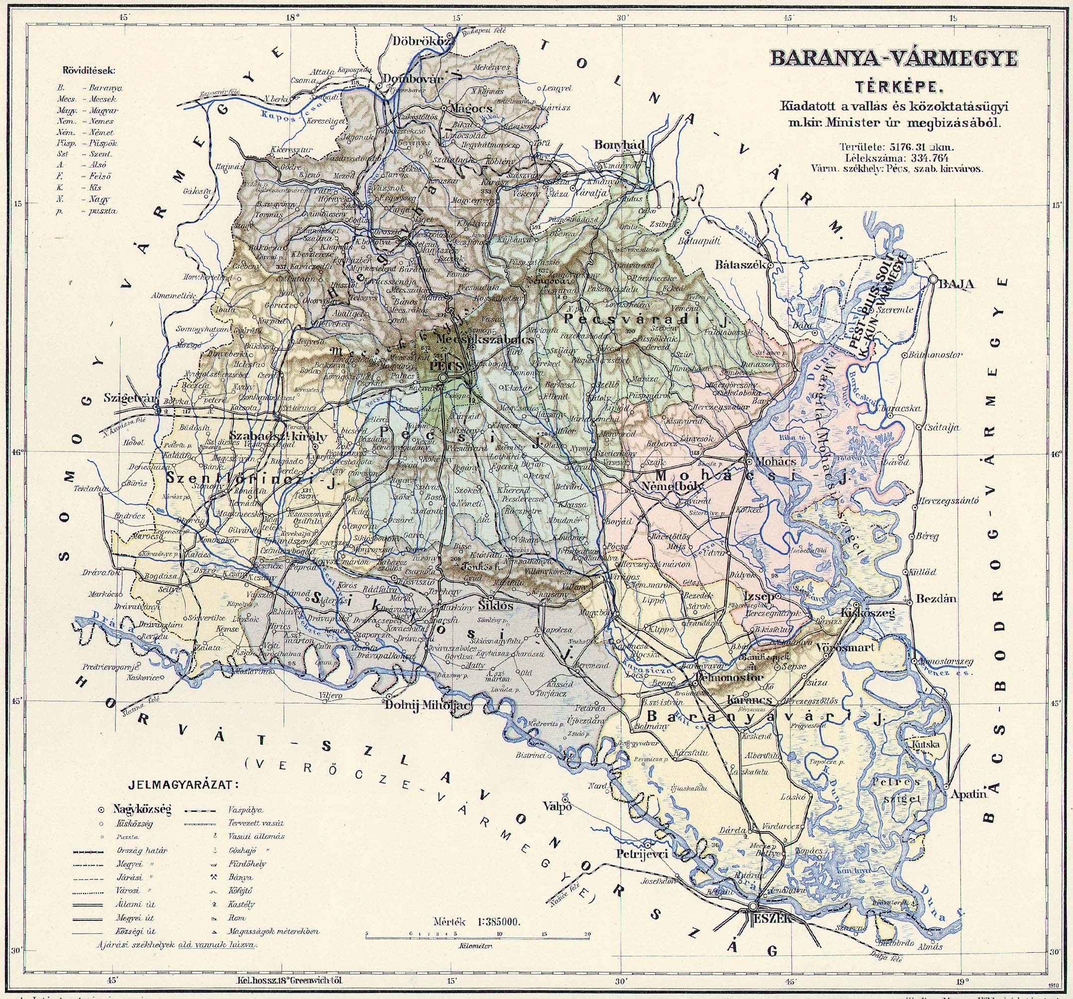
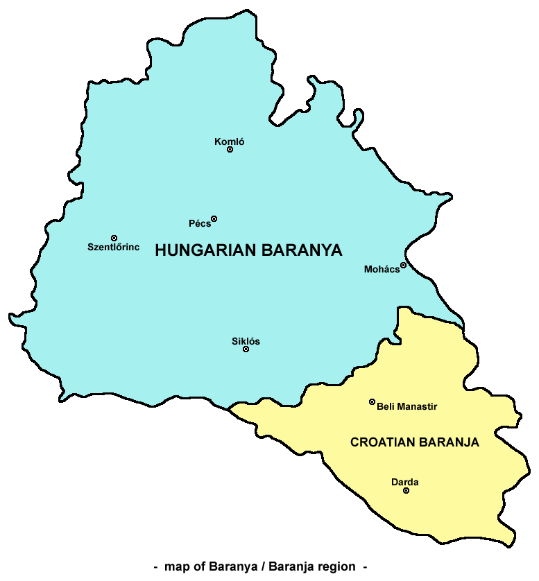
Baranya (, , / Baranja, ) was an administrative county (comitatus) of the Kingdom of Hungary. Its territory is now divided between present-day Baranya County of Hungary and Osijek-Baranja County of Croatia. The capital of the county was Pécs.
Geography
Baranya county was located in Baranya region. It shared borders with the Hungarian counties Somogy, Tolna, Bács-Bodrog and Verőce (the latter county was part of Croatia-Slavonia). The county stretched along the rivers Drava (north bank) and Danube (west bank), up to their confluence. Its area was 5,176 km2 around 1910.
Historical background
Baranya county arose as one of the first counties of the Kingdom of Hungary, in the 11th century. Stephen I of Hungary founded an episcopal seat here. In the 15th century, Janus Pannonius was the Bishop of Pécs. In the 16th century, the Ottoman Empire conquered Baranya, and included it in the sanjak of Mohács, an Ottoman administrative unit, with the seat Turks in Hungary in the city of Mohács.
History
At the end of the 17th century, Baranya was captured by the Habsburg monarchy, and was included in the Habsburg Kingdom of Hungary after the Battle of Mohács (1687). Under the Habsburg rule, German settlers were taken from different parts of Germany, the so-called Danube Swabians.
The Stifolder or Stiffoller Shvove are a Roman Catholic subgroup of the so-called Danube Swabians. Their ancestors arrived ca. 1717–1804 from the Hochstift Fulda and surroundings, (Roman Catholic Diocese of Fulda), and settled in Baranya. They held their own German dialect and culture until the end of WW II; after the war, the majority of Danube Swabians was expelled to Allied-occupied Germany and Allied-occupied Austria subsequent to the Potsdam Agreement. Only a few people can speak the old Stiffolerisch Schvovish dialect. Also a salami is named after these people.
In 1918, the entire Baranya was captured by Serbian troops and was administered by the newly created Kingdom of Serbs, Croats and Slovenes, but as a Republic, see: Baranya-Baja Republic.
By the Treaty of Trianon of 1920, the territory of the county was divided between the Kingdom of Serbs, Croats and Slovenes (renamed to Yugoslavia in 1929) and Hungary. The south-east of the county was assigned to the Kingdom of Serbs, Croats and Slovenes, while the remainder was assigned to Hungary.
The former Yugoslav part of the pre-1920 county was occupied and annexed by Hungary during World War II and the pre-1920 borders of Baranya county were restored in 1941. The post-1920 borders were restored again after World War II and the territory of the county reduced again.
Until the end of World War II, the inhabitants were all Catholic Danube Swabians, also called locally as Stifolder, because the majority of their ancestors arrived in the 17th and 18th centuries from Fulda (district). Most of the former German settlers were expelled to Allied-occupied Germany and Allied-occupied Austria in 1945–1948, consequent to the Potsdam Agreement. Anyway a big Germans of Hungary Minority live in Baranya today.
Since 1991, when Croatia became independent from Yugoslavia, the Yugoslav part of pre-1920 Baranya county is part of Croatia. Between 1991 and 1995 it was under occupation of rebel Croatian Serbs, while from 1995 through 1998 the United Nations administered that area (United Nations Transitional Administration for Eastern Slavonia, Baranja and Western Sirmium) as a transitional body. In modern times there is a Magyar and Serb minority in Croatian Baranja and a Croatian minority in Hungarian Baranya. Roma minority is present in both parts, as well as Germans (mostly until 1945). Today, the present Hungarian county of Baranya also include some lands in the west that were not part of the historic Baranya county (after World War II most of the district of Szigetvár – previously part of Somogy county – and some other localities was transferred to Baranya county).

Demographics
In 1900, the county had a population of 334,764 people and was composed of the following linguistic communities:
Total:
- Hungarian: 183,042 (54.7%)
- Danube Swabians: 111,051 (33.2%)
- Croatian: 15,431 (4.6%)
- Serbian: 12,856 (3.8%)
- Slovak: 482 (0.1%)
- Romanian: 47 (0.0%)
- Ruthenian: 10 (0.0%)
- Other or unknown: 11,845 (3.6%)
According to the census of 1900, the county was composed of the following religious communities:
Total:
- Roman Catholic (term): 253,686 (75.8%)
- Calvinist: 43,014 (12.9%)
- Lutheran: 14,252 (4.3%)
- Greek Orthodox: 13,520 (4.0%)
- Jewish: 9,260 (2.8%)
- Greek Catholic: 201 (0.0%)
- Unitarian: 105 (0.0%)
- Other or unknown: 726 (0.2%)
In 1910, the county had a population of 352,478 people and was composed of the following linguistic communities:
- Hungarian: 199,659 (56.6%)
- Danube Swabians German: 112,297 (31.9%)
- Serbian: 13,048 (3.7%)
- Croatian: 10,159 (2,9)
- Slovak: 392 (0.1%)
- Romanian: 54 (0.0%)
- Ruthenian: 5 (0.0%)
- Other: 16,864 (4.8%)
According to the census of 1910, the county was composed of the following religious communities:
- Roman Catholic: 272,866 (77.4%)
- Calvinist: 41,201 (11.7%)
- Lutheran: 14,617 (4.2%)
- Greek Orthodox: 14,114 (4,0)
- Jewish: 8,828 (2.5%)
- Greek Catholic: 239 (0.0%)
- Unitarian: 89 (0.0%)
- Other: 524 (0.2%)
Subdivisions
In the early 20th century, the subdivisions of Baranya county were:
| Districts (járás) | Population by 1910 census | District | Capital | Settlements | Population by ethnicity | Population by religion | Urban counties (törvényhatósági jogú város) |
|---|---|---|---|---|---|---|---|
| Baranyavár District | Dárda | Albertfalu Baranyabán Baranyaszentistván Baranyavár Bellye Benge Bezedek Bolmány Csúza Dárda Hercegszentmárton Hercegszőlős Illocska Ivándárda Jenőfalva Kácsfalu Karancs Keskend Kisdárda Kiskőszeg Kislippó Kopács Kő Lapáncsa Laskafalu Laskó Lippó Lőcs Magyarbóly Németmárok Pélmonostor Sárok Sepse Várdaróc Villány Virágos Vörösmart | {{Pie chart | thumb = center | caption=total: 49,135 | label1 = Germans of Hungary 19,804 | |
| Hegyhát District | Sásd | Abaliget Ág Alsómocsolád Bakóca Bános Baranyajenő Baranyaszentgyörgy Barátúr Bikal Császta Csikóstőttős Egyházbér Felsőegerszeg Felsőmindszent Gerényes Godisa Gödre Gödreszentmárton Gyümölcsény Hegyhátmaróc Hetvehely Hörnyék Husztót Jágónak Kán Kaposszekcső Karácodfa Kárász Kisbattyán Kisbeszterce Kisbodolya Kishajmás Kishertelend Kisvaszar Komló Kovácsszénája Köblény Liget Mágocs Magyaregregy Magyarhertelend Magyarszék Mánfa Mecsekjánosi Mecsekpölöske Mecsekrákos Mecsekszakál Mekényes Meződ Nagyhajmás Németszék Okorvölgy Orfű Oroszló Palé Pécsbudafa Ráckozár Sásd Szágy Szalatnak Szárász Szászvár Szatina Szentkatalin Szopok Tarrós Tekeres Tékes Tófű Tormás Varga Vásárosdombó Vázsnok Vékény | {{Pie chart | thumb = center | caption=total: 46,882 | label1 = Hungarians 23,256 | |
| Mohács District | Mohács | Babarc Bár Baranyakisfalud Borjád Cseledoboka Dályok Darázs Dunaszekcső Hercegmárok Hercegszabar Izsép Kisnyárád Kölked Lánycsók Liptód Majs Mohács Nagybodolya Nagynyárád Németbóly Pócsa Rácgörcsöny Ráctőttős Somberek Szajk Udvar Versend | {{Pie chart | thumb = center | caption=total: 56,909 | label1 = Germans of Hungary 21,951 | |
| Pécs District | Pécs | ||||||
| Pécsvárad District | Pécsvárad | ||||||
| Siklós District | Siklós | ||||||
| Szentlőrinc District | Szentlőrinc | ||||||
| Pécs |
References
ru:Баранья
References
- "Ihr Herz schlägt im Süden / [1], "Stifoller" Kolonisten in der Tolnau und Branau/Ungarn, 1717-1804; so könnte es gewesen sein".
- "Das Hochstift Fulda".
- (25 July 2018). "The best salami in Hungary".
- [https://www.feked.hu/etc/Stifolder_tortenet.pdf Die Stiffoller und der Stiffolder] feked.hu
- "Die Vertreibung – Landsmannschaft der Deutschen aus Ungarn".
- "KlimoTheca :: Könyvtár". Kt.lib.pte.hu.
- "KlimoTheca :: Könyvtár". Kt.lib.pte.hu.
- "KlimoTheca :: Könyvtár". Kt.lib.pte.hu.
- "KlimoTheca :: Könyvtár". Kt.lib.pte.hu.
This article was imported from Wikipedia and is available under the Creative Commons Attribution-ShareAlike 4.0 License. Content has been adapted to SurfDoc format. Original contributors can be found on the article history page.
Ask Mako anything about Baranya County (former) — get instant answers, deeper analysis, and related topics.
Research with MakoFree with your Surf account
Create a free account to save articles, ask Mako questions, and organize your research.
Sign up freeThis content may have been generated or modified by AI. CloudSurf Software LLC is not responsible for the accuracy, completeness, or reliability of AI-generated content. Always verify important information from primary sources.
Report