From Surf Wiki (app.surf) — the open knowledge base
Baltistan
Region of Pakistani-administered Kashmir

Region of Pakistani-administered Kashmir
| Field | Value |
|---|---|
| name | Baltistan |
| native_name | |
| སྦལ་ཏི་སྟཱན་། Burushaski : baloi | |
| settlement_type | Region in Gilgit-Baltistan |
| image_map | Kashmir Region November 2019.jpg |
| map_caption | A map of the disputed Kashmir region showing the Pakistani administered region of Baltistan, a part of Pakistani-administered Gilgit-Baltistan |
| subdivision_type | Administering Country |
| subdivision_name | Pakistan |
| subdivision_type1 | Territory |
| subdivision_name1 | Gilgit-Baltistan |
| coordinates | |
| pushpin_label_position | bottom |
| area_total_km2 | 30000 |
| area_footnotes | |
| population_as_of | 2022 |
| population_total | 637450 |
| population_footnotes | |
| blank_name_sec1 | Languages |
| blank_info_sec1 | |
| government_type | Divisional Administration |
| leader_title | Commissioner |
| leader_name | Shuja Alam (PAS) |
| leader_title1 | Deputy Inspector General (DIG) |
| leader_name1 | Cap. (R) Liaquat Ali Malik (PSP) |
སྦལ་ཏི་སྟཱན་། Burushaski : baloi Popular culture references Baltistan (, ); also known as Baltiyul or Little Tibet, is a mountainous region in the Pakistani-administered territory of Gilgit-Baltistan and constitutes a northern portion of the larger Kashmir region that has been the subject of a dispute between India and Pakistan since 1947. It is located near the Karakoram (south of K2) and borders Gilgit to the west, China's Xinjiang to the north, Indian-administered Ladakh to the southeast, and the Indian-administered Kashmir Valley to the southwest. The average altitude of the region is over 3350 m. Baltistan is largely administered under the Baltistan Division.
Prior to the partition of British India in 1947, Baltistan was part of the princely state of Jammu and Kashmir, having been conquered by Gulab Singh's armies in 1840. Baltistan and Ladakh were administered jointly under one wazarat (district) of the state. The region retained its identity in this setup as the Skardu tehsil, with Kargil and Leh being the other two tehsils of the district. After Hari Singh, the last maharaja of Jammu and Kashmir, acceded to the Dominion of India in 1947, his local governor in Gilgit was overthrown by the Gilgit Scouts, who then took the entire region for Pakistan during the Indo-Pakistani War of 1947–1948. The Gilgit Agency and Skardu tehsil, as well as a portion of Kargil tehsil, have since been under Pakistani governance while the Kashmir Valley as well as Leh tehsil and most of the Kargil tehsil remain under Indian governance. The Chorbat Valley, geographically in the Baltistan region, was de-facto partitioned when its four villages (with one Bogdang already under Indian control since 1947) were captured by India during the Indo-Pakistani War of 1971, and were incorporated into the erstwhile state of Jammu and Kashmir (now in Ladakh).
The region is inhabited primarily by the Balti people, a largely Muslim ethnic group of Tibetan descent. Baltistan is strategically significant to both Pakistan and India; the Siachen conflict and the Kargil War took place in this region alongside others.
Etymology
Like other Islamic regions near the Indian subcontinent, the name Baltistan is likely created by adding the Persian suffix -istan to the name of the Balti people, who lived here before the Islamic conquests.
Geography

The 1911 Encyclopaedia Britannica characterises Baltistan as the western extremity of Tibet, whose natural limits are the Indus River from its abrupt southward bend around the map point and the mountains to the north and west. These features separate a comparatively peaceful Tibetan population from the Indo-Aryan tribes to the west. Muslim writers around the 16th century speak of Baltistan as the "Little Tibet", and of Ladakh as the "Great Tibet", emphasising their ethnological similarity. According to Ahmad Hassan Dani, Baltistan spreads upwards from the Indus river and is separated from Ladakh by the Siachen Glacier. It includes the Indus valley and the lower valley of the Shyok river.
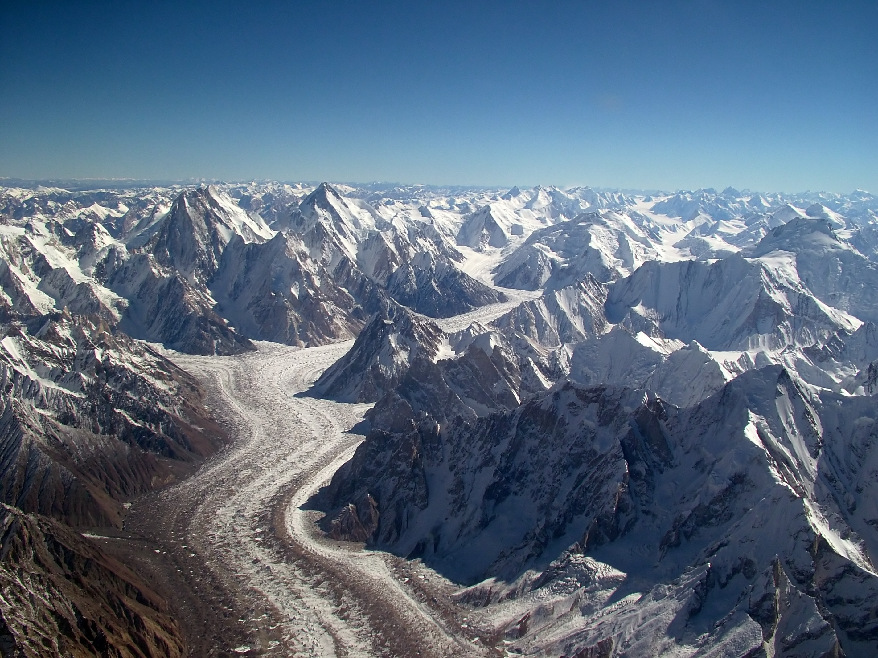
Baltistan is a rocky mass of lofty mountains, the prevailing formation being gneiss. In the north is the Baltoro Glacier, one of the longest glaciers outside of the polar regions, 35 mi long, contained between two ridges whose highest peaks to the south are 25000 ft and to the north 28265 ft.
The Indus river runs in a narrow gorge, widening after receiving the Shyok river at . It then forms a 20 mi crescent-shaped plain varying between 1 and in width. The main inhabitable valleys of Kharmang, Khaplu, Skardu, Shigar and Roundu are along the routes of these rivers.
The village of Chalunkha, now in Leh district, is traditionally considered the southernmost settlement of Baltistan, delimiting it from the Nubra region of Ladakh. The traditional boundary of Baltistan with Ladakh along Nubra valley was finalised in the early 19th century by the ruler of Khaplu, while that of along Suru valley was demarcated at Ghargurdo, between Ganokh and Garkon, in the 17th century following a battle between the Balti king Ali Sher Anchan and Gyalpo Jamyang Namgyal. Ruins of a series of watchtowers, which were jointly guarded by the both kingdoms, are still found here. A few villages of the Kharmang ilaqa, such as Hardas and Karkichu in the Suru River Valley, remained part of Kargil after the First Kashmir War. They mark the former southern boundary of Baltistan, and are populated by ethnic Baltis till today.
Administration
The Baltistan is one of three divisions of Gilgit-Baltistan. The Division of Baltistan is administed under a BPS-20 Commissioner of Pakistan Administrative Service group of Central Superior Services of Pakistan. The current Commissioner Baltistan Division is Shula Alam (PAS).
Valleys and districts
| Valley | District | District Area (km2) | Population (1998) | Capital |
|---|---|---|---|---|
| Khaplu | ||||
| Ghanche | 8,531 | 88,366 | Khaplu | |
| Skardu | ||||
| Skardu | 10,168 | 219,209 | Skardu | |
| Shigar | ||||
| Shigar | 4,173 | 60,295 | Center Shigar | |
| Kharmang | ||||
| Kharmang | 6,144 | 62,522 | Tolti | |
| Roundu | ||||
| Roundu | ... | 80,000 | Dambudas | |
| Chorbat° | ||||
| Leh and | 883 | Turtuk |
°*Although part of Baltistan, Chorbat valley has been de-facto partitioned between Pakistan and India, after territorial exchanges during 1972 Simla treaty.
History
{{anchor|Origin of Baltis and Baltistan}}Origins

Today, the people of Kharmang and Eastern Khaplu have Tibetan features and those in Skardu, Shigar and the western villages of Khaplu are Dards. It was believed that the Balti people were in the sphere of influence of Zhangzhung. Baltistan was controlled by the Tibetan king in 686. Culturally influenced by Tibet, the Bon and animist Baltis began to adopt Tibetan Buddhism. Religious artifacts such as gompas and stupas were built, and lamas played an important role in Balti life.
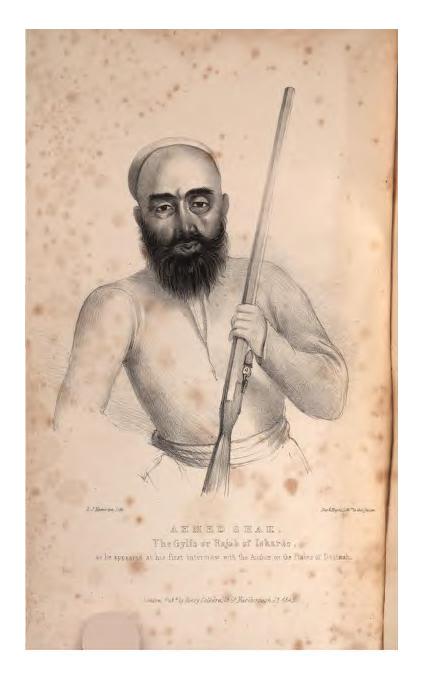
For centuries, Baltistan consisted of small, independent valley states connected by the blood relationships of its rulers (rajas), trade, common beliefs and cultural and linguistic bonds. Baltistan was known as Little Tibet, and the name was extended to include Ladakh. Ladakh later became known as Great Tibet. Locally, Baltistan is known as Baltiyul and Ladakh and Baltistan are known as Maryul ("red country").
Medieval and Early Modern History
Medieval Baltistan was divided into three main kingdoms: Skardu, Shigar, and Khaplu. The Maqpon dynasty, which ruled from Skardu, also later established side branches at Kartaksho and Roundu.
During the 14th century, Muslim scholars from Kashmir crossed Baltistan's mountainous terrain to spread Islam. The Noorbakshia Sufi order further propagated the faith in Baltistan and Islam became dominant by the end of the 17th century. With the passage of time a large number also converted to Shia Islam and a few converted to Sunni Islam.
In 1190, Maqpon dynasty of Skardu was founded by Ibrahim Shah (1190-1220), who was born in Skardu. This royal family ruled over Baltistan for approximately 700 years. The kings of the Maqpon dynasty extended the frontiers of Baltistan to Gilgit Agency, Chitral, and Ladakh. In the late 1500s/early 1600s, the Maqpon rulers of Skardu expanded their kingdom to include Shigar, Astor, Rondu, and Karataksha. The greatest ruler during this period was Alī Sher Khān, known as "Anchan", or "the Great". After the Mughal conquest of Kashmir in 1586, during the reign of Anchan's grandfather Ghāzī Mīr, diplomatic relations developed between the Mughals and the Maqpon rulers of Baltistan. A Balti princess was sent to the Mughal court, and according to local tradition, a Mughal princess was also sent to Skardu and built a Mughal-style fort at Mandok. Around 1595, the Mughal historian Abu'l-Fazl wrote that Kashmir was then importing silkworm eggs (for sericulture) from Gilgit and Baltistan.

The Kharmang came under the control of the Namgyal royal family and developed a close relationship with Ladakh when the raja of Ladakh, Jamyang Mangyal, attacked the principalities in Kargil. Mangyal annihilated the Skardu garrison at Kharbu and put to the sword a number of petty Muslim rulers in the principalities of Purik (Kargil). Ali Sher Khan Anchan, raja of Khaplu and Shigar, left with a strong army via Marol. Passing the Laddakhi army, he occupied Leh (the capital of Ladakh) and the raja of Ladakh was taken prisoner.
Ali Sher Khan Anchan included Gilgit and Chitral in his kingdom of Baltistan, reportedly a flourishing country. The valley from Khepchne to Kachura was flat and fertile, with abundant fruit trees; the sandy desert now extending from Sundus to Skardu Airport was a prosperous town. Skardu had hardly recovered from the shock of the death of Anchan when it was flooded.
After the death of Anchan in 1633, the Maqpon polity declined as his three sons fought among themselves. One of them, Adam Khān, had fled to Kashmir and then sought refuge with the Mughal emperor Jahāngīr while Anchan was still alive. In 1637, Adam accompanied a Mughal expedition into Baltistan led by Zafar Khān. Adam's elder brother (and rival) Abdāl was captured, and Zafar Khān announced Mughal suzerainty over Baltistan. However, with winter coming, Zafar hastily withdrew his troops from Baltistan and appointed one of Abdāl's partisans to govern the territory on his behalf, which upset the Mughal emperor Shāh Jahān. Ultimately, though, Adam Khān ended up taking control of Baltistan. Both he and his successor, Murād Khān, acknowledged Mughal suzerainty.
The Kingdom of Khaplu probably came into existence around the 10th century following the breakup of the Tibetan Empire. Its ruling dynasty was known as the Yabgu dynasty, after the Turkish title of yabghu. The local population was Buddhist up until around the 14th century, when Sayyid Alī Hamadānī is credited with spreading Islam to the region. Khaplu was conquered by Skardu under Alī Sher Khān Anchan in the early 1600s. From then on, it was administered by a governor, or kharpon, appointed by the ruler in Skardu. The last kharpon was Yulehing Karīm, who governed Khaplu from 1820 to 1840, when the Dogra commander Zorāwar Singh conquered it.
The official Mughal historian Abdul Hamid Lahori left an account of Baltistan in his entry for the year 1638. He wrote that Baltistan had 22 parganas and 37 forts. Its narrow mountain valleys could support limited cultivation, primarily of wheat and barley; certain fruits also thrived in the local climate. Rather poor-quality gold was collected from river sands in small amounts – only about 2,000 tolas (about 9.5 kg) was collected per year.
In 1840, the region was subjugated by the Dogra rulers of Jammu under the suzerainty of the Sikh Empire. On 29 August 2009 the government of Pakistan announced the creation of Gilgit–Baltistan, a provincial autonomous region with Gilgit as its capital and Skardu its largest city.
Tourism
Skardu has several tourist resorts and many natural features, including plains, mountains and mountain-valley lakes. The Deosai plain, Satpara Lake and Basho also host tourists. North of Skardu, the Shigar Valley offers plains, hiking tracks, peaks and campsites. Other valleys in Baltistan region are Khaplu, Rondu, Kachura Lake and Kharmang.
{{anchor|Glaciers in Baltistan}}Glaciers
Baltistan is a rocky wilderness of around 27000 sqmi, with the largest cluster of mountains in the world and the biggest glaciers outside the polar regions. The Himalayas advance into this region from India, Tibet and Nepal, and north of them are the Karakoram range. Both ranges run northwest, separated by the Indus River. Along the Indus and its tributaries are many valleys. Glaciers include Baltoro Glacier, Biafo Glacier, Siachen Glacier, Trango Glacier and Godwin-Austen Glacier.
{{anchor|Panorama}}Mountaineering

Baltistan is home to more than 20 peaks of over 20000 ft, including K2 (the second-highest mountain on earth. Other well-known peaks include Masherbrum (also known as K1), Broad Peak, Hidden Peak, Gasherbrum II, Gasherbrum IV and Chogolisa (in the Khaplu Valley). The following peaks have been scaled:
| Name | Height | Date climbed | Location | |
|---|---|---|---|---|
| K2 | [[File:K2 2006b.jpg | 100px]] | 28,250 ft | 31 July 1954 |
| Gasherbrum I | [[File:Gasherbrum2.jpg | 100px]] | 26,360 ft | 7 July 1956 |
| Broad Peak | [[File:7 15 BroadPeak.jpg | 100px]] | 26,550 ft | 9 June 1957 |
| Muztagh Tower | [[File:MuztaghTower.jpg | 100px]] | 23,800 ft | 6 August 1956 |
| Gasherbrum II | [[File:Gasherbrum2.jpg | 100px]] | 26,120 ft | 4 July 1958 |
| Hidden Peak | [[File:HiddenPeak.jpg | 100px]] | 26,470 ft | 4 July 1957 |
| Khunyang Chhish | [[File:Kunyang Pumari Chhish.JPG | 100px]] | 25,761 ft | 4 July 1971 |
| Masherbrum | [[File:Masherbrum.jpg | 100px]] | 25,659 ft | 4 August 1960 |
| Saltoro Kangri | [[File:Saltoro Kangri.jpg | 100px]] | 25,400 ft | 4 June 1962 |
| Chogolisa | [[File:Chogolisa.jpg | 100px]] | 25,148 ft | 4 August 1963 |
Demographics
The region has a population of about 303,214 as of 2017. Gilgit-Baltistan, City Population web site, retrieved 12 May 2022. It is a blend of ethnic groups, predominantly Baltis, and Tibetans. A few Kashmiris settled in Skardu, practicing agriculture and woodcraft.
Religion
Before the arrival of Islam, Tibetan Buddhism and Bön (to a lesser extent) were the main religions in Baltistan. Buddhism can be traced back to before the formation of the Tibetan Empire in the region during the seventh century. The region has a number of surviving Buddhist archaeological sites. These include the Manthal Buddha Rock, a rock relief of the Buddha at the edge of the village (near Skardu) and the Sacred Rock of Hunza. Nearby are former sites of Buddhist shelters.
Islam was brought to Baltistan by Sufi missionaries during the 16th and 17th centuries, and most of the population converted to Noorbakshia Islam. The scholars were followers of the Kubrawiya Sufi order. Most Noorbakhshi Muslims live in Ghanche.
{{anchor|Domesticated animals|Wild animals}}Fauna

Baltistan has been called a living museum for wildlife. Deosai National Park, in the southern part of the region, is habitat for predators since it has an abundant prey population. Domestic animals include yaks (including hybrid yaks), cattle, sheep, goats, horses and donkeys. Wild animals include ibex, markhor, musk deer, snow leopards, brown and black bears, jackals, foxes, wolves and marmots.
Culture
Balti music and art

According to Balti folklore, Mughal princess Gul Khatoon (known in Baltistan as Mindoq Gyalmo—Flower Queen) brought musicians and artisans with her into the region and they propagated Mughal music and art under her patronage. Musical instruments such as the surnai, karnai, dhol and chang were introduced into Baltistan.
Dance
Classical and other dances are classified as sword dances, broqchhos and Yakkha and ghazal dances. Chhogho Prasul commemorates a victory by the Maqpon rajas. As a mark of respect, the musician who plays the drum (dang) plays for a long time. A Maqpon princess would occasionally dance to this tune. Gasho-Pa, also known as Ghbus-La-Khorba, is a sword dance associated with the Gasho Dynasty of Purik (Kargil). Sneopa, the marriage-procession dance by pachones (twelve wazirs who accompany the bride), is performed at the marriage of a raja.
Architecture

Balti architecture has Tibetan and Mughul influences, and its monastic architecture reflects the Buddhist imprint left on the region. Buddhist-style wall paintings can be seen in forts and Noorbakhshi khanqahs, including Chaqchan Mosque in Khaplu, Amburik Mosque in Shigar, Khanqah e Muallah Shigar, Khaplu Fort, Shigar Fort and Skardu Fort.
{{anchor|Sports}}Polo
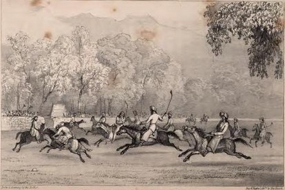
Polo is popular in Baltistan, and indigenous to the Karakoram region, having been played there since at least the 15th–16th century. The Maqpon ruler Ali Sher Khan Anchan introduced the game to other valleys during his conquests beyond Gilgit and Chitral. The English word polo derives from the Balti word polo, meaning "the ball used in the game of polo". The game of polo itself is called Hrthapolo means horse riding game in Balti.
Media
The Pakistan Broadcasting Corporation has radio and television stations in Khaplu that broadcast local programs, and there are a handful of private news outlets. The Daily K2 is an Urdu newspaper published in Skardu serving Gilgit-Baltistan for long time, and it is the pioneer of print media in Gilgit Baltisatn. Bad-e-Shimal claims the largest daily circulation in Gilgit and Baltistan.
Notes
Bibliography
References
- Dryland, Estelle. (2022). "The Many Faces of King Gesar: Tibetan and Central Asian Studies in Homage to Rolf A. Stein". BRILL.
- "Gilgit Baltistan at a Glance 2022. Published in 2023".
- (6 September 2021). "How Many Languages Are Spoken In Pakistan".
- "Baltistan". Oxford University Press.
- Schofield, Victoria. (2003). "Kashmir in Conflict". I. B. Taurus & Co.
- Cheema, Brig Amar. (2015). "The Crimson Chinar: The Kashmir Conflict: A Politico Military Perspective". Lancer Publishers.
- (1968). "Proceedings - Punjab History Conference". Punjabi University.
- Kaul, H. N.. (1998). "Rediscovery of Ladakh". Indus Publishing.
- Census of India 1961. Volume VI: Jammu and Kashmir. PART II-A: GENERAL POPULATION TABLES. Published 1964. pp. 23, 53, 75, 104. Quote: "Thirty-one villages of Tehsil Kargil (Serial Nos. 21–29, 33–53 and 90 of Village Tables of 1941) being on the other side of the cease-fire line."
- CENSUS OF INDIA, 1911. Volume XX: Kashmir. PART I: REPORT. pp. 52, 63. Published 1912. Quote: "The Kharmang ilaqa from Skardu, and Zanskar from Kishtwar, were included in the newly formed tehsil."
- (1890). "Gazetteer of Kashmir and Ladak". Superintendent of Government Printing.
- Gupta, Radhika. (2023). "Freedom in Captivity: Negotiations of Belonging along Kashmir's Frontier". Cambridge University Press.
- Schofield, Victoria. (2003). "Kashmir in Conflict". I. B. Taurus & Co.
- Atul Aneja, [http://www.thehindu.com/thehindu/2001/01/11/stories/0211000h.htm A 'battle' in the snowy heights]{{dead link. (April 2021)
- (July 2013). "In pictures: Life in Baltistan". bbc.com.
- Dani, Ahmad Hasan. (1991). "History of Northern Areas of Pakistan". National Institute of Historical and Cultural Research, Quaid-i-Azam University.
- Swift, Hugh. (1990). "Trekking in Pakistan and India". London: Hodder & Stoughton.
- Vohra, Rohit. (1982). "Ethnographic Notes on the Buddhist Dards of Ladakh: The Brog-Pā". Zeitschrift für Ethnologie.
- Gupta, Radhika. (2023). "Freedom in Captivity: Negotiations of Belonging along Kashmir's Frontier". Cambridge University Press.
- Tarar, Mustansar Hussain. (1991). "Nanga Parbat".
- ''Where Indus is Young''
- Afridi, Banat Gul. (1988). "Baltistan in history". Emjay Books International.
- Tarekh e jammu, molvi hashmatullah
- Hussainabadi, Muhammad Yousuf: ''Baltistan per Aik Nazar'' 1984
- "A Socio-Political Study of Gilgit Baltistan Province". Pakistan Journal of Social Sciences.
- Yousaf Hussain Abadi, ''A view on Baltistan''
- (2003). "History of Civilizations of Central Asia, Volume V". UNESCO Publishing.
- "Baltistan - North Pakistan".
- (30 April 1998). "Little Tibet: Renaissance and Resistance in Baltistan".
- "Tareekh e Baltistan".
- "Baltis".
- (30 June 2012). "Kashmir: Its Aborigines and Their Exodus". Amber Books Limited.
- Hussainabadi, Muhammad Yousuf: ''Tareekh-e-Baltistan'' 2003
- Tikoo, Tej K.. (2012). "Kashmir: Its Aborigines and Their Exodus". Lancer International Incorporated.
- (April 2008). "The last colony: Muzaffarabad-Gilgit-Baltistan". India Research Press with Centre for Strategic and Regional Studies, University of Jammu.
- (1993). "Proceedings of the International Seminar on the Anthropology of Tibet and the Himalaya: September 21-28 1990 at the Ethnographic Museum of the University of Zurich". Völkerkundemuseum der Universität Zürich.
- Ali, Manzoom (12 June 2004). Archaeology of Dardistan.
- Gertel, Jörg. (2011). "Economic Spaces of Pastoral Production and Commodity Systems". Ashgate.
- "ABOUT GILGIT-BALTISTAN".
- Hussain, Ejaz. "Geography and Demography of Gilgit Baltistan".
- "NYF".
- "Sofia Imamia Noorbakhshia".
- "Beautiful Gilgit Baltistan".
- "BALTI MUSIC AND ART".
- Hussainabadi, Muhammad Yousuf: ''Balti Zaban'' 1990
- Wallace, Paul (1996). A History of Western Himalayas. Penguin Books, London.
- Malcolm D. Whitman, ''Tennis: Origins and Mysteries'', Published by Courier Dover Publications, 2004, {{ISBN. 0-486-43357-9, p. 98.
- Dani, Ahmad Hassan: ''History of Northern Areas of Pakistan'', National Institute of Historical Research, Islamabad, 1991.
- Skeat, Walter William. (1898). "A Concise Etymological Dictionary of the English Language". Harper.
- Afridi, Banat Gul. (1988). "Baltistan in history". Emjay Books International.
- "Radio Pakistan".
- "dailyk2".
- "Daily Bad e Shimal".
This article was imported from Wikipedia and is available under the Creative Commons Attribution-ShareAlike 4.0 License. Content has been adapted to SurfDoc format. Original contributors can be found on the article history page.
Ask Mako anything about Baltistan — get instant answers, deeper analysis, and related topics.
Research with MakoFree with your Surf account
Create a free account to save articles, ask Mako questions, and organize your research.
Sign up freeThis content may have been generated or modified by AI. CloudSurf Software LLC is not responsible for the accuracy, completeness, or reliability of AI-generated content. Always verify important information from primary sources.
Report