From Surf Wiki (app.surf) — the open knowledge base
Baker, California
Census designated place in California, United States

Census designated place in California, United States
| Field | Value |
|---|---|
| name | Baker, California |
| settlement_type | Census designated place |
| image_skyline | 2010-0615-BakerCA.jpg |
| image_caption | Aerial view of Baker looking north: I-15 jogs south around the town, leaving Baker Boulevard, the main street, to show where the pre-interstate highway (US 91 and US 466) went. Baker Airport sits just north of the city alongside northbound CA 127, the "Death Valley Road". |
| pushpin_map | USA California#USA |
| pushpin_label_position | |
| pushpin_map_caption | Location within the state of California |
| image_map | San_Bernardino_County_California_Incorporated_and_Unincorporated_areas_Baker_Highlighted_0603512.svg |
| map_caption | Location in San Bernardino County and the state of California |
| subdivision_type | Country |
| subdivision_name | |
| subdivision_type1 | State |
| subdivision_name1 | California |
| subdivision_type2 | County |
| subdivision_name2 | San Bernardino |
| leader_title | |
| unit_pref | Imperial |
| area_footnotes | |
| area_total_sq_mi | 2.69 |
| area_land_sq_mi | 2.69 |
| area_water_sq_mi | 0.00 |
| area_total_km2 | 6.96 |
| area_land_km2 | 6.96 |
| area_water_km2 | 0.00 |
| area_water_percent | 0 |
| population_as_of | 2020 |
| population_total | 442 |
| population_density_sq_mi | 164.43 |
| population_density_km2 | 63.49 |
| timezone | Pacific |
| utc_offset | -8 |
| timezone_DST | PDT |
| utc_offset_DST | -7 |
| elevation_footnotes | |
| elevation_ft | 942 |
| coordinates | |
| postal_code_type | ZIP codes |
| postal_code | 92309 |
| area_code_type | Area codes |
| area_code | 442/760 |
| blank_name | FIPS code |
| blank_info | |
| blank1_name | GNIS feature ID |
| blank1_info | 2628708 |
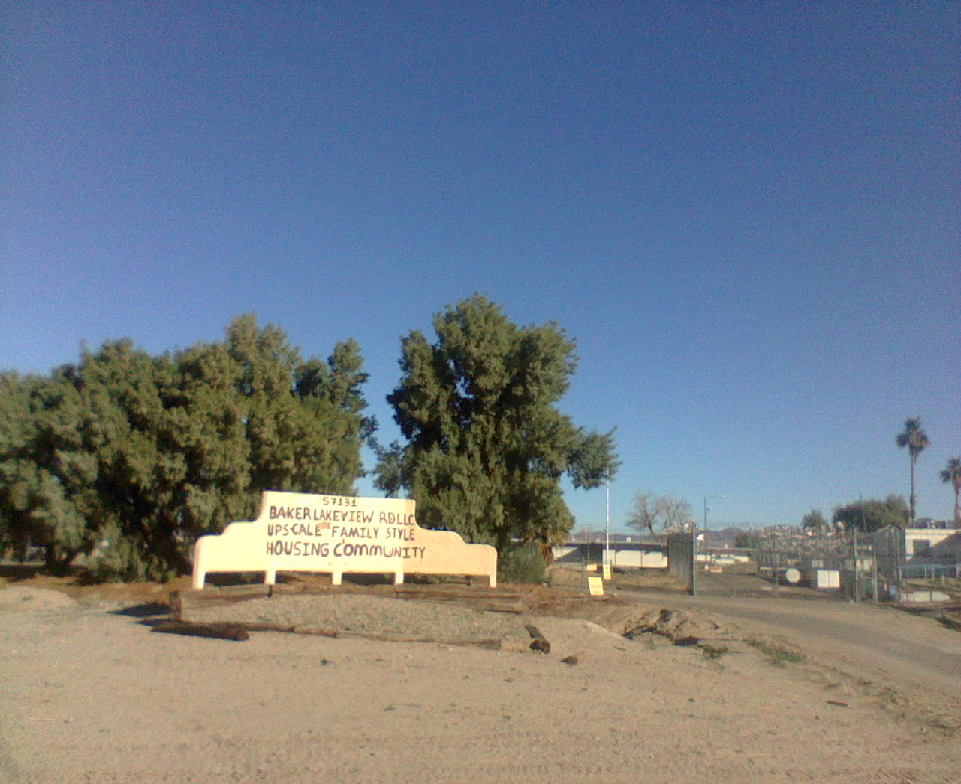
Baker is a census-designated place located in San Bernardino County, California, US. As of the 2020 census, the CDP had a total population of 442. Baker's ZIP Code is 92309 and the community is within area codes 442 and 760.
History
Baker was founded as a station on the Tonopah and Tidewater Railroad in 1908 and was named for Richard C. Baker, business partner of Francis Marion Smith in building the railroad. Baker later became president of the T&T himself.
Baker was established in 1929 by Ralph Jacobus Fairbanks (1857–1942), who was an American prospector, entrepreneur, and pioneer who established several towns in the Death Valley area of California, including Fairbanks Springs (1904–05) and Shoshone (1910).
It is the site of a vacant, 223-bed for-profit prison formerly operated by Cornell Corrections which experienced a major riot on December 2, 2003, four weeks before it was temporarily closed. It was permanently closed on December 25, 2009. GEO Group purchased Cornell Companies, its owner, on August 12, 2010. It had previously experienced escapes in August and November 1995 and two on July 15, 1997.
Geography and climate
Baker is located in the Mojave Desert at the junction of Interstate 15 and SR 127 (Death Valley Road). Its elevation is approximately 930 ft above sea level, which is much lower than either Barstow or Las Vegas, due to its location at the southern end of the Death Valley geological depression. The Cronese Mountains are located southwest of the community. According to the United States Census Bureau, the CDP covers an area of 2.7 square miles (7.0 km), all of it land. Summer temperatures in Baker routinely exceed 110 °F; 2007 saw a record of 125 °F.
|Jan record high F = 80 |Feb record high F = 92 |Mar record high F = 96 |Apr record high F = 106 |May record high F = 116 |Jun record high F = 119 |Jul record high F = 124 |Aug record high F = 124 |Sep record high F = 119 |Oct record high F = 110 |Nov record high F = 92 |Dec record high F = 82 |year record high F = 124 |Jan record low F = 16 |Feb record low F = 21 |Mar record low F = 24 |Apr record low F = 34 |May record low F = 38 |Jun record low F = 43 |Jul record low F = 53 |Aug record low F = 54 |Sep record low F = 42 |Oct record low F = 32 |Nov record low F = 23 |Dec record low F = 14 |year record low F = 14
Demographics
|align-fn=center 1850–1870 1880-1890 1900 1910 1920 1930 1940 1950 1960 1970 1980 1990 2000 2010
Baker first appeared as a census designated place in the 2010 U.S. census.
The 2020 United States census reported that Baker had a population of 442. The population density was 164.4 PD/sqmi. The racial makeup of Baker was 21.3% White, 0.5% African American, 36.9% Native American, 1.8% Asian, 1.1% Pacific Islander, 28.1% from other races, and 10.4% from two or more races. Hispanic or Latino of any race were 78.1% of the population.
The whole population lived in households. There were 125 households, out of which 40.8% included children under the age of 18, 52.8% were married-couple households, 8.8% were cohabiting couple households, 16.8% had a female householder with no partner present, and 21.6% had a male householder with no partner present. 21.6% of households were one person, and 5.6% were one person aged 65 or older. The average household size was 3.54. There were 89 families (71.2% of all households).
The age distribution was 33.7% under the age of 18, 11.1% aged 18 to 24, 24.7% aged 25 to 44, 24.4% aged 45 to 64, and 6.1% who were 65years of age or older. The median age was 28.6years. For every 100 females, there were 101.8 males.
There were 167 housing units at an average density of 62.1 /mi2, of which 125 (74.9%) were occupied. Of these, 28.0% were owner-occupied, and 72.0% were occupied by renters.
Economy
Baker's economy is based primarily on tourism. The town is frequently used as a stop for food and fuel by drivers on Interstate 15 between Los Angeles and Las Vegas. Baker is approximately 90 mi southwest of Las Vegas. It is the last town for those traveling on SR 127 north to Death Valley National Park or south to the Mojave National Preserve. Until recently there was one motel in Baker, the Santa Fe Motel, formerly the Wills Fargo Motel, but as of 2023 the motel has closed.
Baker Airport is a small facility owned by the U.S. Department of the Interior, Bureau of Land Management, but it is managed by San Bernardino County Department of airports
Government
State and federal representation
In the California State Legislature, Baker is in , and in .
In the United States House of Representatives, Baker is in .
Since Baker is an unincorporated community of San Bernardino County, County CEO, Leonard X. Hernandez, would be considered the Chief Administrator of Baker.
Water, Sanitary Sewers, Trash Collection Services, Fire Protection, Television Translators, Road Maintenance, Street Lighting, Park and Recreation is administered by the Baker Community Services District
Mars rover test site
The Mars Science Laboratory Team tested an engineering model of the Curiosity rover in the desert near Baker.
Education
The CDP is in the Baker Valley Unified School District.
Attractions
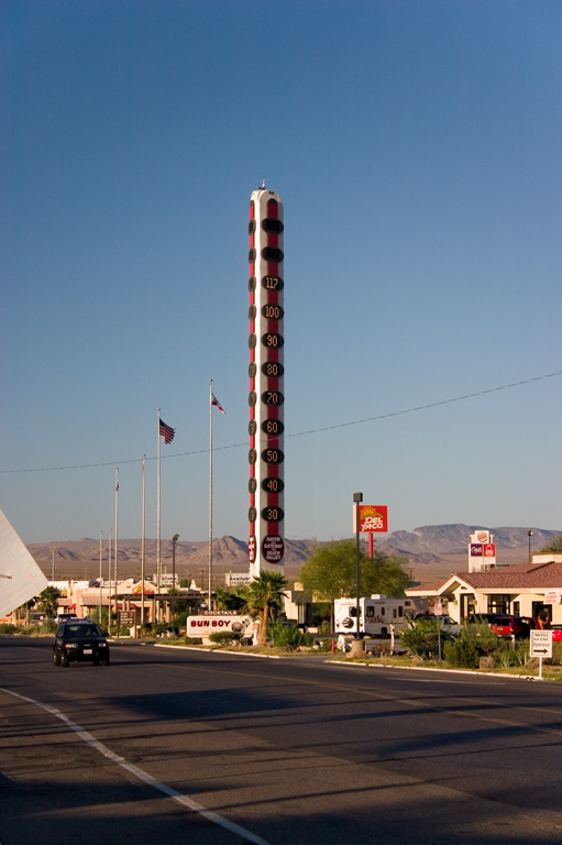
- The town's most prominent feature is a 134 ft thermometer, dubbed "the world's tallest thermometer". Its height commemorates the hottest temperature ever recorded on Earth, 134 °F, in nearby Death Valley on July 10, 1913. It was created by Willis Herron, who owned many businesses in Baker and, at one point, was said to have employed half of Baker's population. Hoping to draw more visitors into Baker, Herron partnered with Young Electric Sign Co. in 1991 to build the monument. It originally cost $750,000 to build and was blown over by high winds before it was officially lit. It was quickly rebuilt with a sturdier design. In 2005, Herron sold several of his businesses to Matt Pike in 2005 before dying in 2007. Visible for miles, Pike temporarily stopped its operation in 2012 due to expensive electric bills of $8,000/month and inaccurate temperature readings. When Herron's widow Barbara learned that the beloved landmark was being considered for demolition, she repurchased and refurbished it. The thermometer was relighted following restoration on July 10, 2014.
- The thermometer was featured on the television show Strange Inheritance season 1 episode 13 on the Fox Business Network.
- Alien Fresh Jerky, a quirky store selling various types of jerky and alien-themed merchandise. The store is itself a tourist attraction with statues of aliens and architecture resembling galactic ships. Billboards on I-15 commonly feature the store. In 2020, the store came under fire for controversial racist remarks against Asians.
- Abandoned structures, such as the tiki-inspired Arnie's Royal Hawaiian Motel (opened in 1957, closed in 2009, formerly known as Grace's Oasis) and Bun Boy Restaurant and Motel (opened in 1926, closed in 2013), are popular amongst urban explorers.
- Dumont Dunes Off-Highway Vehicle Area, a popular area for ATV riders.
- Just a few miles to the west along I-15 lies the exit for Zzyzx Road. This dirt road leads to Soda Springs, the site of the health resort established by Curtis Springer in the late 1940s and now the Desert Study Center maintained by the California State University.
- A yearly race is held called "The Challenge Cup Relay: Baker to Vegas" or commonly referred as "Baker to Vegas" where law enforcement do a relay running race from Baker, CA to Las Vegas, NV. It attracts law enforcement agencies including LAPD, national, and international agencies to participate annually.
In popular culture
- The 2003 film The Big Empty takes place in Baker, California. It was also filmed on-location.
- In the video game Fallout: New Vegas, the fictional town of Novac features as a main attraction the world's second-largest thermometer.
- The second season of the Fallout TV series utilized Baker as a filming location for scenes set in Novac.
References
References
- "2020 U.S. Gazetteer Files". United States Census Bureau.
- {{GNIS. 2628708
- Bright, William. (1998). "1500 California Place Names: Their Origin and Meaning". University of California Press.
- Hildebrand, George Herbert. (1982). "Borax Pioneer: Francis Marion Smith". Howell-North Books.
- [http://www.8newsnow.com/story/1549434/prison-riot-investigation-underway Prison Riot Investigation Underway] {{Webarchive. link. (April 14, 2015 , [[KLAS-TV]], December 3, 2003. Retrieved 8 April 2015.)
- [http://www.dof.ca.gov/osae/audit_reports/documents/bakercommunitycorrectionalfacility.pdf Final Audit Report—Baker Community Correctional Facility, Contract R05.006] {{Webarchive. link. (2016-03-14 , ''[[State of California]]'' Department of Finance, April 11, 2011. Retrieved 25 February 2016.)
- [http://corrections.oregonafscme.com/private/recent_escapes_from_private_pris.htm Recent escapes from private prisons 1995-2000] {{Webarchive. link. (2012-01-18 , Oregon [[AFSCME]], 2000. Retrieved 25 February 2016.)
- "Decennial Census by Decade".
- "1870 Census of Population - Population of Civil Divisions less than Counties - California - Almeda County to Sutter County".
- "1870 Census of Population - Population of Civil Divisions less than Counties - California - Tehama County to Yuba County".
- "1890 Census of Population - Population of California by Minor Civil Divisions".
- "1900 Census of Population - Population of California by Counties and Minor Civil Divisions".
- "1910 Census of Population - Supplement for California".
- "1920 Census of Population - Number of Inhabitants - California".
- "1930 Census of Population - Number and Distribution of Inhabitants - California".
- "1940 Census of Population - Number of Inhabitants - California".
- "1950 Census of Population - Number of Inhabitants - California".
- "1960 Census of Population - Number of Inhabitants - California".
- "1970 Census of Population - Number of Inhabitants - California".
- "1980 Census of Population - Number of Inhabitants - California".
- "1990 Census of Population - Population and Housing Unit Counts - California".
- "2000 Census of Population - Population and Housing Unit Counts - California".
- "2010 Census of Population - Population and Housing Unit Counts - California".
- "Baker CDP, California; DP1: Profile of General Population and Housing Characteristics - 2020 Census of Population and Housing".
- "Baker CDP, California; P16: Household Type - 2020 Census of Population and Housing".
- "Baker Airport".
- "Final Maps {{!}} California Citizens Redistricting Commission".
- {{Cite GovTrack. CA. 23
- CSD, Baker. "Baker Community Services District".
- (December 9, 2013). "An Inside Look at the Mars Curiosity Rover".
- "2020 CENSUS - SCHOOL DISTRICT REFERENCE MAP: San Bernardino County, CA". [[U.S. Census Bureau]].
- Willon, Phil. (24 December 2012). "Baker's giant thermometer, long on the blink, is taking heat". [[Los Angeles Times]].
- PlacesThatWere. "Gateway to Death Valley: The Broken Dreams of Baker, California".
- Rocha, Veronica. (12 July 2014). "World's tallest thermometer in Baker shines bright again". [[Los Angeles Times]].
- Editorial Staff. (2020-05-09). "Beef Jerky Boss Sends Racist Email to 'Oriental' Client, Blames Poor English Skills".
- (2014). "Dumont Dunes Off-Highway Vehicle Area". Bureau of Land Management, California.
- (2014). "The Official Baker to Vegas Website". bakervegas.com.
- "The Big Empty (2003) - Filming & production - IMDb".
This article was imported from Wikipedia and is available under the Creative Commons Attribution-ShareAlike 4.0 License. Content has been adapted to SurfDoc format. Original contributors can be found on the article history page.
Ask Mako anything about Baker, California — get instant answers, deeper analysis, and related topics.
Research with MakoFree with your Surf account
Create a free account to save articles, ask Mako questions, and organize your research.
Sign up freeThis content may have been generated or modified by AI. CloudSurf Software LLC is not responsible for the accuracy, completeness, or reliability of AI-generated content. Always verify important information from primary sources.
Report