From Surf Wiki (app.surf) — the open knowledge base
Ayta ash-Shaab
Municipality in Nabatieh Governorate, Lebanon
Municipality in Nabatieh Governorate, Lebanon
| Field | Value |
|---|---|
| name | Ayta ash-Shaab |
| native_name | عيتا الشعب |
| native_name_lang | ar |
| settlement_type | Municipality |
| image_skyline | File:Aita2.jpg |
| image_caption | Ayta ash Shab |
| pushpin_map | Lebanon |
| pushpin_map_alt | Map showing the location of Ayta ash-Shaab within Lebanon |
| pushpin_map_caption | Location within Lebanon |
| coordinates | |
| grid_position | 181/277 PAL |
| subdivision_type | Country |
| subdivision_name | Lebanon |
| subdivision_type1 | Governorate |
| subdivision_name1 | Nabatieh Governorate |
| subdivision_type2 | District |
| subdivision_name2 | Bint Jbeil District |
| established_title | |
| elevation_m | 650 |
| population_density_km2 | auto |
| timezone1 | EET |
| utc_offset1 | +2 |
| timezone1_DST | EEST |
| utc_offset1_DST | +3 |
| postal_code_type | Postal code |
| area_code_type | Dialing code |
| area_code | +961 |
Ayta ash-Shaab (; also transliterated Ayta al-Sha'b or Ayta al-Shab)"The tall mountain of the spur", according to Palmer, 1881, p. 66 is a municipality located in southern Lebanon, about 2.22 km northeast of the Israeli border. The majority of its population are Shia Muslims.
History
Antiquity
Ayta ash-Shaab is identified with Ayta (), a place referenced in the Baraita on the "Boundaries of the Land of Israel" as part of the delineation of the northwestern border of Jewish resettlement following the return from Babylonian exile.
Ottoman era
In 1596, it was named as a village, 'Ayta Bani Salman in the Ottoman nahiya (subdistrict) of Tibnin under the liwa' (district) of Safad, with a population of 5 Muslim households. The villagers paid a fixed tax of 25% on agricultural products, such as wheat, barley, goats and beehives, in addition to "occasional revenues"; a total of 930 akçe.
In 1875 Victor Guérin noted: "The village has taken the place of a small town surrounded by a wall, of which some remains still exist in well-cut stones and a fort measuring forty paces long by twenty-five broad. Beneath this building lies a large cistern vaulted with circular arches, and built of regularly cut stones. It is covered by a platform, on part of which has been built, later on, a little mosque, now falling into ruins. Here one may remark columns which come from an older building, the site of which is marked by a mass of blocks regularly cut, and by mutilated shafts lying upon the ground.
Below the village, the upper slopes of the hill are cultivated in terraces, and planted with vines, fig-trees, pomegranates, olives, and filberts. Here I found several cisterns, a great sepulchral cave, ornamented with arched arcosolia, each surmounting two sarcophagi, contiguous and parallel, a press with two compartments, one square and the other circular, the whole cut in the living rock.
Ascending towards the east, I passed beside an ancient pool half cut in the rock and half built. Not far is an old evergreen oak, one of the most remarkable that I have seen in Palestine, to which the inhabitants offer a kind of worship. It is protected by a little wall which supports the venerable trunk."
In 1881, the PEF's Survey of Western Palestine (SWP) described it: A well-built village of stone, situated on hill-top, with figs, olives, and arable land. It contains about 200 Moslems (Guerin says Metawileh), and has water from several cisterns and birket near. "Here are foundations of walls, built with well-dressed stones. Several sarcophagi were observed. On the east, south and west of village there are also two olive-presses and two rock-cut cisterns."
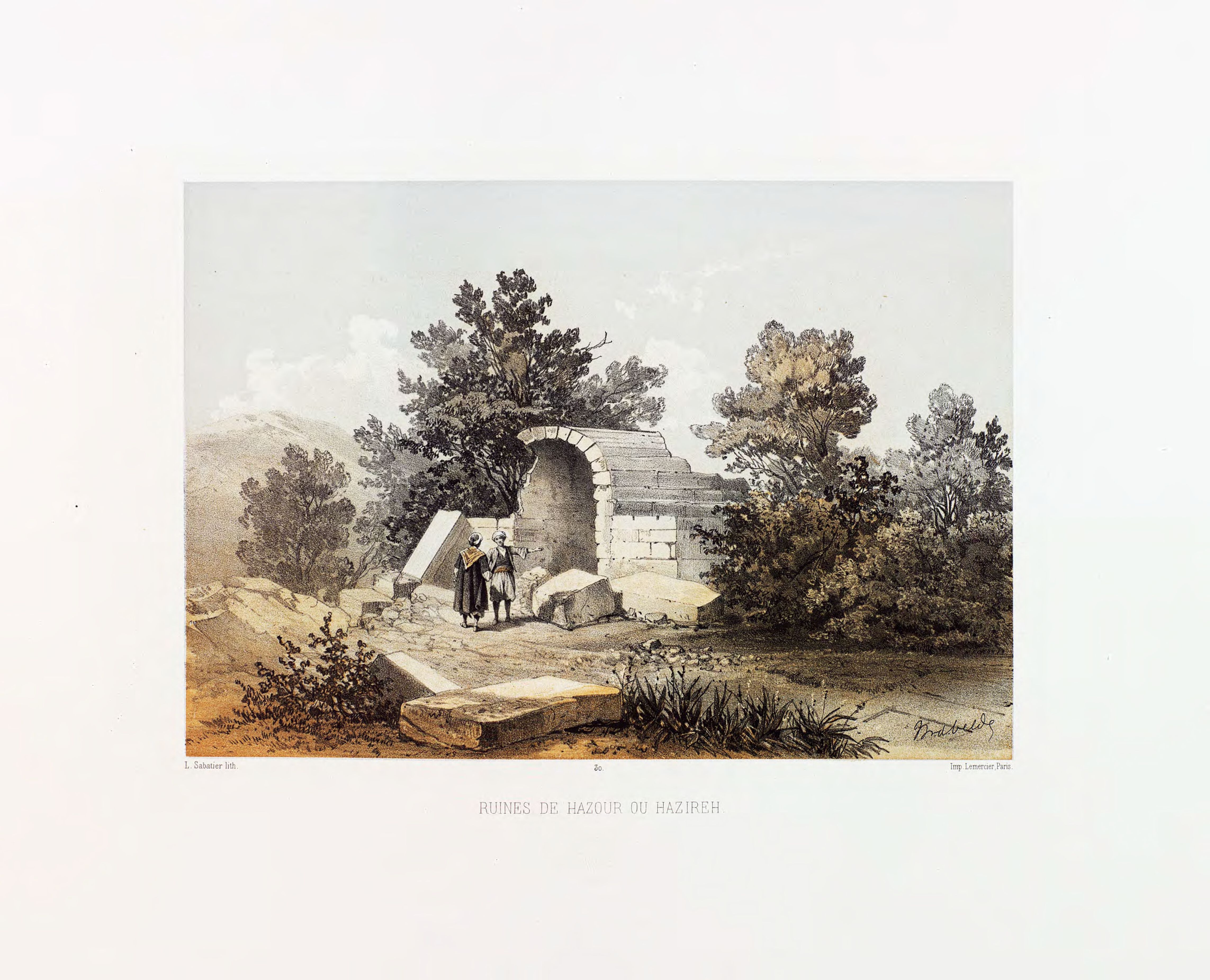
The ruins of Khirbet Hazireh (Hazzirya) are located 2 km northeast of Ayta ash-Shaab, described by C.W.M. Van De Velde in 1851.
Modern era
Main article: Battle of Ayta ash-Shab
During the 2006 Lebanon War, 85% of Ayta ash-Shaab's homes were destroyed, and heavy ground fighting ensued between Israeli forces and Hezbollah.
On 20 July 2006, one civilian in the village was killed, and the next day three more civilian villagers were killed, all by Israeli fire. The victims were reported by the Human Rights Watch as having no relation to Hezbollah.
During the Israel–Hezbollah conflict, Hezbollah members used the village to fire missiles and coordinate attacks against Israel. Israel launched numerous airstrikes at the village in response. Almost all residents of the village have left, while frequent Israeli airstrikes and artillery barrages have reduced it to rubble, as it also happened in most nearby communities, while others, such as the Christian-inhabited town of Marjayoun, have been spared.
On 1 October 2024, the IDF claimed that since the onset of the Israel–Hezbollah conflict in October 2023 and leading up to the October 2024 ground operation, it had destroyed 103 "terror targets" in Ayta ash-Shaab, including 51 tunnel shafts and nine rocket launchers, with tunnels reaching approximately 25 meters deep. As of October 25th more than 80% of the village has been destroyed.
Demographics
In 2014 Muslims made up 99.64% of registered voters in Ayta ash-Shaab. 98.37% of the voters were Shiite Muslims.
References
Bibliography
- {{cite book
- {{cite book
- {{cite book
- {{cite book
- {{cite book
References
- Wedeman, Ben. (2024-06-24). "'This area has a geographical curse': Residents along Lebanon's border with Israel fear another war".
- (1983). "The Northwest Corner of Eretz-Israel in the Baraita 'Boundaries of Eretz-Israel". Cathedra: For the History of Eretz Israel and Its Yishuv.
- Hütteroth and Abdulfattah, 1977, p. 180
- Note that Rhode, 1979, p. [https://www.academia.edu/2026845/The_Administration_and_Population_of_the_Sancak_of_Safed_in_the_Sixteenth_Century 6] {{Webarchive. link. (2019-04-20 writes that the register that Hütteroth and Abdulfattah studied was not from 1595/6, but from 1548/9)
- Guérin, 1880, p. [https://archive.org/stream/descriptiongogr00gugoog#page/n137/mode/1up 119]; as translated by Conder and Kitchener, 1881, SWP I, p. [https://archive.org/stream/surveyofwesternp01conduoft#page/219/mode/1up 219]
- Conder and Kitchener, 1881, SWP I, p. [https://archive.org/stream/surveyofwesternp01conduoft#page/200/mode/1up 200]
- Conder and Kitchener, 1881, SWP I, p. [https://archive.org/stream/surveyofwesternp01conduoft#page/219/mode/1up 219]
- Rosen, N.. (2007-01-01). "The Mayor, the Martyr, and the Pomegranate Trees". Mother Jones.
- Bouckaert, Peter. (5 September 2007). "Why They Died : Civilian Casualties in Lebanon during the 2006 War". [[Human Rights Watch]].
- (October 2024). "Israel, Hezbollah exchange fire, raising regional tensions".
- "Israeli Strike On Lebanon Kills Hezbollah Member: Officials".
- Wedeman, Ben. (24 June 2024). "'This area has a geographical curse': Residents along Lebanon's border with Israel fear another war".
- (1 October 2024). "IDF invasion of southern Lebanon meets no Hezbollah resistance".
- "التوزيع حسب المذاهب للناخبين/ناخبات في بلدة عيتا الشعب، قضاء بنت جبيل محافظة النبطية في لبنان".
This article was imported from Wikipedia and is available under the Creative Commons Attribution-ShareAlike 4.0 License. Content has been adapted to SurfDoc format. Original contributors can be found on the article history page.
Ask Mako anything about Ayta ash-Shaab — get instant answers, deeper analysis, and related topics.
Research with MakoFree with your Surf account
Create a free account to save articles, ask Mako questions, and organize your research.
Sign up freeThis content may have been generated or modified by AI. CloudSurf Software LLC is not responsible for the accuracy, completeness, or reliability of AI-generated content. Always verify important information from primary sources.
Report