From Surf Wiki (app.surf) — the open knowledge base
Arvagh
Village in County Cavan, Ireland
Village in County Cavan, Ireland
| Field | Value |
|---|---|
| name | Arvagh |
| native_name | Ármhach |
| native_name_lang | ga |
| settlement_type | Town |
| image_skyline | Market House, Arvagh - geograph.org.uk - 1301295.jpg |
| image_caption | Market House |
| pushpin_map | Ireland |
| pushpin_label_position | right |
| pushpin_map_caption | Location in Ireland |
| subdivision_type | Country |
| subdivision_name | Ireland |
| subdivision_type1 | Province |
| subdivision_name1 | Ulster |
| subdivision_type2 | County |
| subdivision_name2 | County Cavan |
| subdivision_type3 | Barony |
| subdivision_name3 | Tullyhunco |
| unit_pref | Metric |
| population_as_of | 2022 |
| population_footnotes | |
| population_total | 419 |
| coordinates |
Arvagh (), or Arva, is a town in County Cavan, Ireland, on the shores of Garty Lough and overlooked by Bruse Mountain. It is located on the junction of the R198 and R203 regional roads.
It is situated in the centre of the drumlin belt on the border of Counties Longford and Leitrim. Its location is about 3 km southeast of the tripoint where the three provinces of Ulster, Leinster and Connacht meet.
As of 2022, the town had a population of 419.
Toponymy
Árṁaċ, or Ármhach (meaning "Battlefield" or "Place of Slaughter"), was brought about because Arvagh is on the borders of 3 counties and provinces, Leitrim, Longford and Cavan (Connaght, Leinster and Ulster). The royal families of these counties would battle in Arvagh and as a result many died, Hence "Place of Slaughter". In 1836, Arvagh was recorded by John O'Donovan as Airbheach, 'a division'. Under descriptive marks it was recorded that "The town of Arvagh is small...The word Arvagh is derived from a rocky spot in the adjoining townland and on which the despensary is built, which signifies the place of blood or slaughter"
Local folklore, recorded in the Dúchas Schools' Collection, supports this interpretation, associating the name with historical battles in the surrounding area. However, as is common with early Irish toponyms, there is no definitive historical record of a specific event giving rise to the name, and it may also refer more broadly to a territorial or symbolic landscape feature. Another entry from the Schools' Collection records that "the real name for the town is Drumalt," implying that this may have been the original name before it became known as Arva.
History
Early history
Arva (Irish Ármhach, "battlefield") lies at the western edge of the barony of Teallach Dhúnchadha (Tullyhunco) in County Cavan. Archaeological surveys have recorded over twenty ringforts (ráth) in and around the townland, indicating continuous settlement from the 6th to the 10th centuries.
In the early medieval period the area formed part of the over‑kingdom of Breifne, ruled by the Uí Briúin Breifne dynasty. From the 11th century the local túath of Tullyhunco was governed by the Mág Tighearnán sept, whose chiefs administered Brehon law and collected tribute from their crannóg at Cruachan O'Cúbhrán.
Between the 8th and 12th centuries Breifne consolidated into West Breifne (under the O'Rourke kings) and East Breifne (under the O'Reilly kings). Tullyhunco, including Arva, was absorbed into East Breifne by the mid‑13th century, a division confirmed by conflicts such as the Battle of Magh Slécht in 1256. This Gaelic lordship remained until the Tudor conquest of Ireland in the 16th century.
Plantation and foundation of the town
Gaelic control began to collapse during the late 16th century, particularly following the Nine Years' War (1594–1603) and the Flight of the Earls (1607). These events paved the way for the Plantation of Ulster, a policy of land confiscation and colonisation carried out by the English Crown. Arva, along with much of southern Ulster, was granted to British settlers. The modern town was likely established during this plantation period in the early 17th century.
18th and 19th century development
During the 18th and 19th centuries, Arva developed further under the control of the Gosford estate, which was held by the Acheson family, later the Earls of Gosford. Surviving estate maps from 1822 and 1845 show a formally planned town layout centred around a market house and fair green.
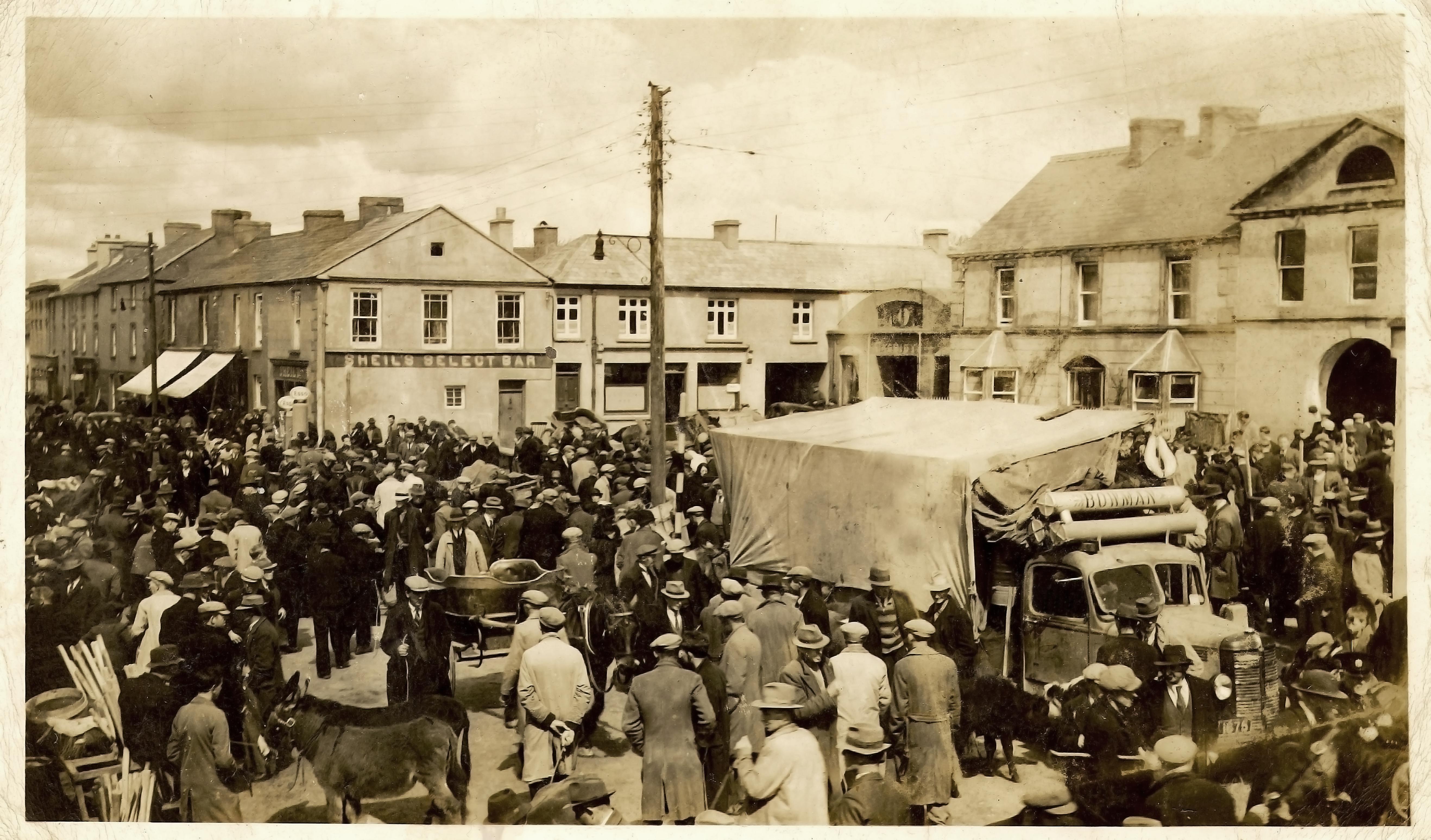
In 1841, at which time the 1841 Census recorded a population of 69, there were four pubs in the village and the monthly fairs were of considerable local trade importance.
Early 20th century
A valuable snapshot of life in Arva during the early 20th century is preserved in the Schools' Collection, compiled in the 1930s by local schoolchildren as part of a nationwide folklore project.
A snapshot of life in Arva during the early 20th century is preserved in the Schools' Collection, compiled in the 1930s by local schoolchildren as part of a nationwide folklore project. One account, written by Joy Scott of Arva National School on 18 March 1938, describes how the town was transitioning into the modern era, with the arrival of electricity:
"There is electric light in the town which brightens it very much at night, there are lights along the streets and in nearly every house. Long ago there was only oil lamps on the street which did not show much light but now that is replaced by the electricity."
The same contributor described the town's layout and social life during the 1930s:
"There are four streets in the town namely: Main Street, Pound Street, Broad Road and Longford Street. There are a few fine buildings in the town. There are three large dances halls namely 'St. Patrick's Hall', 'Moonlight Pavilion' and 'Memorial Hall'. The guards barrick, the post office, three banks, a chapel and a church. There is a fair held once a month in the town and a market each week. In the summer evenings the young people play tennis, camogie, football and lots of other games and in winter there are many amusements such as pictures, dances, and concerts."
Governance
Arva is located within the jurisdiction of Cavan County Council, in the local electoral area of Ballyjamesduff, one of the three electoral areas used for local elections within the county.
For national representation, Arva is part of the Dáil constituency of Cavan–Monaghan. At the European level, Arva falls is in the Midlands–North-West constituency, which elects five Members of the European Parliament (MEPs).
Demographics
Historical population data for Arva often refers to the wider civil parish of Arvagh, which encompasses the town and surrounding rural area, rather than the town alone. The parish historically covered approximately 17,074 statute acres. In 1837, the population of the parish was recorded as 4,580, of whom 422 resided in the town itself. Throughout the 19th century, the parish population declined significantly, reflecting trends in rural depopulation, famine, and emigration.
| Year | Arva Parish | Arva Town | Population | ±% | Population | ±% | |||||||
|---|---|---|---|---|---|---|---|---|---|---|---|---|---|
| 1837 | 4,580 | — | 422 | — | |||||||||
| 1861 | 6,294 | — | no data available | — | |||||||||
| 1871 | 5,777 | −8.2% | no data available | — | |||||||||
| 1881 | 5,606 | −3.0% | no data available | — | |||||||||
| 1891 | 4,912 | −12.4% | no data available | — | |||||||||
| 1901 | 4,381 | −10.8% | no data available | — | |||||||||
| 1911 | 3,994 | −8.8% | no data available | — | |||||||||
| 1921 | no data available | — | no data available | — | |||||||||
| 1931 | no data available | — | no data available | — | |||||||||
| 1941 | no data available | — | no data available | — | |||||||||
| 1951 | no data available | — | no data available | — | |||||||||
| 1961 | no data available | — | no data available | — | |||||||||
| 1971 | no data available | — | no data available | — | |||||||||
| 1981 | no data available | — | no data available | — | |||||||||
| 1991 | no data available | — | no data available | — | |||||||||
| 1996 | no data available | — | 327 | — | |||||||||
| 2002 | no data available | — | title=Census 2002 | url=https://www.cso.ie/en/media/csoie/census/documents/vol1_t7_t12.pdf | archive-url=https://web.archive.org/web/20201211151757/https://www.cso.ie/en/media/csoie/census/documents/vol1_t7_t12.pdf | archive-date=11 December 2020 | website=Central Statistics Office}} | +9.2% | |||||
| 2006 | no data available | — | 364 | +2.0% | |||||||||
| 2011 | no data available | — | 380 | +4.4% | |||||||||
| 2016 | no data available | — | date=2016 | title=Sapmap Area: Settlements Arva | url=https://census.cso.ie/sapmap2016/Results.aspx?Geog_Type=ST2016&Geog_Code=A4E767CC-4BBC-4B2A-9D5E-B3B06B92D616 | archive-url=https://web.archive.org/web/20180213080353/http://census.cso.ie/sapmap2016/Results.aspx?Geog_Type=ST2016&Geog_Code=A4E767CC-4BBC-4B2A-9D5E-B3B06B92D616 | archive-date=13 February 2018 | access-date=16 April 2025 | work=Census 2016 | publisher=Central Statistics Office}} | +8.2% | ||
| 2022 | no data available | — | 419 | +1.9% |
Irish language
The 2022 census reported the following language proficiency among Arva residents:
- English only: 96.2%
- Irish speakers: 28.5%
- Other languages: 3.8%
Of those who spoke Irish, a small percentage used it daily outside the education system.
Events
Each year the Arvagh Agricultural Show takes place in the village. The "3 Province Festival" also takes place here over 10 days from the last weekend in July until the first weekend in August. The festival includes music, theatre, comedy, art, competitions and other events.
Transport
Bus
Whartons Travel operate bus route 975 on behalf of the National Transport Authority. It serves the village six times a day (not Sundays) providing services to Longford via Drumlish and Cavan. Bus Éireann route 465, (Carrigallen-Killashandra-Cavan) serves the village on Tuesday.
Rail
Arva Road railway station on the erstwhile Killashandra branch was the nearest station to Arvagh. Nowadays bus route 975 provides a link to Longford railway station.
Angling
The Arvagh area has numerous angling sites such as Garty Lough, Hollybank Lake, Gulladoo Lake, Guiniken Lake and Rockfield Lake. The Arvagh International Fishing Festival takes place in Arvagh every September.
Sport
Arva St Patrick's is the local Gaelic Athletic Association club.
References
References
- "Census Interactive Map – Towns: Arvagh". [[Central Statistics Office (Ireland).
- "Ármhach/Arvagh". [[Department of Culture, Heritage and the Gaeltacht]] and [[Dublin City University]].
- O'Neill, Kevin. (2003). "Family and Farm in Pre-Famine Ireland". University of Wisconsin Press.
- "Arva". Cavan Tourism.
- "My Home District". National Folklore Collection, UCD.
- O'Donovan, Patrick F.. (1995). "Archaeological inventory of County Cavan". The Stationery Office.
- "Arvagh - County Cavan". Discover Ireland.
- "Arvagh". The Schools' Collection.
- (1892). "Marriages, Births, and Deaths Registered in Ireland 1891". Registrar-General (Ireland).
- Lewis, Samuel. (1837). "A Topographical Dictionary of Ireland". S. Lewis & Co..
- (1872). "Marriages, Births, and Deaths in Ireland 1869". Registrar-General.
- (1874). "Marriages, Births and Deaths in Ireland 1871". Registrar-General.
- (1885). "Marriages, births, and deaths in Ireland 1884".
- (1897). "Marriages, births, and deaths registered in Ireland during the year 1896".
- (1902). "Marriages, births, and deaths registered in Ireland during the year 1901".
- (1913). "Marriages, births and deaths registered in Ireland during the year 1912".
- "Census 2002".
- "Census 2006 – Table 5".
- "Census 2011 – Table 5".
- (2016). "Sapmap Area: Settlements Arva". [[Central Statistics Office (Ireland).
- "Population of Towns by Size, Census 2022".
- (14 April 2012). "The Breffni Challenge".
- "Arva Show - Arva Agricultural Show Society".
- (2018-08-26). "Arva 3 Province Festival {{!}} Arva 3 Province Festival is a GO!!! Starts with the Arva Show & finishes August Bank Holiday.".
- "Route 975 Cavan - Arvagh- Longford Bus Service Commences - National Transport AuthorityNational Transport Authority".
- "Whartons Travel - Cavan to Longford Bus - Longford to Cavan Bus".
- (19 April 2018). "Angling Ireland – Arva". [[Inland Fisheries Ireland]].
This article was imported from Wikipedia and is available under the Creative Commons Attribution-ShareAlike 4.0 License. Content has been adapted to SurfDoc format. Original contributors can be found on the article history page.
Ask Mako anything about Arvagh — get instant answers, deeper analysis, and related topics.
Research with MakoFree with your Surf account
Create a free account to save articles, ask Mako questions, and organize your research.
Sign up freeThis content may have been generated or modified by AI. CloudSurf Software LLC is not responsible for the accuracy, completeness, or reliability of AI-generated content. Always verify important information from primary sources.
Report