From Surf Wiki (app.surf) — the open knowledge base
Area of Outstanding Natural Beauty
Designated area of countryside in England, Wales, and Northern Ireland

Designated area of countryside in England, Wales, and Northern Ireland
An Area of Outstanding Natural Beauty (AONB; , AHNE) is one of 46 areas of countryside in England, Wales, or Northern Ireland that has been designated for conservation due to its significant landscape value. Since 2023, the areas in England and Wales have also adopted the name National Landscape ().
Areas are designated in recognition of their national importance by the relevant public body: Natural England, Natural Resources Wales, and the Northern Ireland Environment Agency respectively. On 22 November 2023, following a review, the AONBs in England and Wales adopted the National Landscapes name, and are in the process of rebranding. AONBs in Northern Ireland did not rename. The name "area of outstanding natural beauty" is still the designated legal term.
In place of the term AONB, Scotland uses the similar national scenic area (NSA) designation. Areas of Outstanding Natural Beauty enjoy levels of protection from development similar to those of UK national parks, but unlike national parks the responsible bodies do not have their own planning powers. They also differ from national parks in their more limited opportunities for extensive outdoor recreation.
There are 46 Areas of Outstanding Natural Beauty, 33 wholly in England, four wholly in Wales, one on the England–Wales border, and eight in Northern Ireland.
History
The idea for what would eventually become the AONB designation was first put forward by John Dower in his 1945 Report to the Government on National Parks in England and Wales. Dower suggested there was need for protection of certain naturally beautiful landscapes that were unsuitable as national parks owing to their small size and lack of wildness. Dower's recommendation for the designation of these "other amenity areas" was eventually embodied in the National Parks and Access to the Countryside Act 1949 as the AONB designation.
Purpose
The purpose of an AONB designation is to conserve and enhance the natural beauty of the designated landscape.
There are two secondary aims: meeting the need for quiet enjoyment of the countryside and having regard for the interests of those who live and work there. To achieve these aims, AONBs rely on planning controls and practical countryside management. As they have the same landscape quality, AONBs may be compared to the national parks of England and Wales. National parks are well known in the UK; by contrast, there is evidence to indicate many residents in AONBs may be unaware of the status. However, the National Association of AONBs is working to increase awareness of AONBs in local communities, and, in 2014, successfully negotiated to have the boundaries of AONBs in England shown on Google Maps.
Statistical overview

There are 46 Areas of Outstanding Natural Beauty in the United Kingdom: 33 in England, four in Wales, one on the England–Wales border, and eight in Northern Ireland. The first AONB was established in 1956 on the Gower Peninsula in South Wales, and the most recent to be designated is the Tamar Valley AONB, established in 1995. More recent changes include the Clwydian Range AONB being extended in 2012 to form the Clwydian Range and Dee Valley AONB, and the Strangford Lough and Lecale Coast AONBs being merged to form a single AONB in 2010.
AONBs vary greatly in terms of size, type and use of land, and whether they are partly or wholly open to the public. The smallest AONB is the Isles of Scilly, 16 km2, and the largest is the Cotswolds, 2038 km2. AONBs cover around 15% of England and 4% of Wales.
Legal status and organisation
AONBs in England and Wales were originally created under the same legislation as the national parks, the National Parks and Access to the Countryside Act 1949. Unlike AONBs, national parks have special legal powers to prevent unsympathetic development. AONBs in general remain the responsibility of their local authorities by means of special committees that include members appointed by a minister and by parishes, and only very limited statutory duties were imposed on local authorities within an AONB by the original 1949 Act. However, further regulation and protection of AONBs in England and Wales was added by the Countryside and Rights of Way (CRoW) Act 2000, under which new designations are now made,
In the National Planning Policy Framework (March 2012), the government stated that AONBs and national parks have equal status when it comes to planning decisions on landscape issues. Two of the AONBs (the Cotswolds and the Chilterns), which extend into a large number of local authority areas, have their own statutory bodies, known as conservation boards. In 2019 the Glover Report made various recommendations regarding the future of AONBsthe report's 'central proposal' being to bring National Parks and AONBs together as part of one 'family of national landscapes'but as at 1 November 2020 the government has yet to respond to those recommendations. However, the Cotswolds Conservation Board announced in September 2020 that they were re-styling the area name and it is now known as the Cotswolds National Landscape.
All English and Welsh AONBs have a dedicated AONB officer and other staff. As required by the CRoW Act, each AONB has a management plan that sets out the characteristics and special qualities of the landscape and how they will be conserved and enhanced. The AONBs are collectively represented by the National Association for Areas of Outstanding Natural Beauty (NAAONB), an independent registered charity acting on behalf of AONBs and their partners, which uses the slogan "Landscapes for Life".
AONBs in Northern Ireland was designated originally under the Amenity Lands (NI) Act 1965; subsequently under the Nature Conservation and Amenity Lands (NI) Order 1985.
On 22 November 2023, following a 2022 Landscapes Review policy paper by Julian Glover, the AONBs in England and Wales adopted the National Landscapes name, and are in the process of rebranding. The name "area of outstanding natural beauty" is still the designated legal term. The review did not extend to Northern Ireland, and its AONBs did not adopt the new name.
Threats
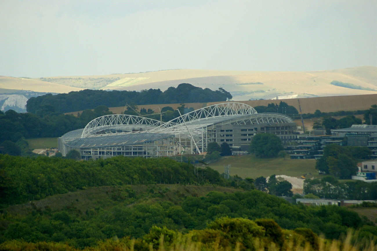
There are growing concerns among environmental and countryside groups that AONB status is increasingly under threat from development. The Campaign to Protect Rural England said in July 2006 that many AONBs were under greater threat than ever before. Three particular AONBs were cited: the Dorset AONB threatened by a road plan, the threat of a football stadium in the Sussex Downs AONB, and, larger than any other, a £1 billion plan by Imperial College London to build thousands of houses and offices on hundreds of acres of AONB land on the Kent Downs at Wye. In September 2007 government approval was finally given for the development of a new football ground for Brighton and Hove Albion within the boundaries of the Sussex Downs AONB, after a fierce fight by conservationists. The subsequent development, known as Falmer Stadium, was officially opened in July 2011. The Weymouth Relief Road in Dorset was constructed between 2008 and 2011, after environmental groups lost a High Court challenge to prevent its construction.
Writing in 2006, Professor Adrian Phillips listed threats facing AONBs, which he says include uncertainty over future support for land management, increasing development pressures, the impacts of globalization, and climate change. More subtle threats include creeping suburbanization and horsiculture.
Celebration
Poet Laureate Simon Armitage wrote a poem "Fugitives", commissioned by the National Association of AONBs, which he read on Arnside Knott on 21 September 2019 to launch the celebration of the 70th anniversary of the National Parks and Access to the Countryside Act.
List of Areas of Outstanding Natural Beauty
England
| AONB | Photo | Established | Area | Local authorities | ||||
|---|---|---|---|---|---|---|---|---|
| Arnside and Silverdale | [[File:Arnside123.jpg | 150px]] | 1972 | 75 km2 | ||||
| Blackdown Hills | [[File:CulmstockBeacon.jpg | 150px]] | 1991 | 370 km2 | ||||
| Cannock Chase | [[File:Cannock_Chase_Path.jpg | 150px]] | 1958 | 68 km2 | Staffordshire (Cannock Chase, Lichfield) | |||
| Chichester Harbour | [[File:Bosham.1.5.05.jpg | 150px]] | 1964 | 37 km2 | ||||
| Chilterns | [[File:Ivinghoe_Beacon_seen_from_The_Ridgeway.jpg | 150px]] | 1965 | 833 km2 | ||||
| Cornwall | [[File:Cape Cornwall (Judithili) edit.jpg | 150px]] | 1959 | 958 km2 | Cornwall | |||
| Cotswolds | [[File:Bibury_Cottages_in_the_Cotswolds_-_June_2007.jpg | 150px]] | 1966 | 2038 km2 | ||||
| Cranborne Chase and West Wiltshire Downs | [[File:Dorset brings 01.jpg | 150px]] | 1981 | 983 km2 | ||||
| Dedham Vale | [[File:Cmglee Manningtree River Stour.jpg | 150px]] | 1970 | 90 km2 | ||||
| Dorset | [[File:Durdle Door Overview.jpg | 150px]] | 1959 | 1129 km2 | Dorset | |||
| East Devon | [[File:Snow05_009.jpg | 150px]] | 1963 | 268 km2 | Devon (East Devon) | |||
| Forest of Bowland | [[File:Langden_Brook_-_geograph.org.uk_-_342024.jpg | 150px]] | 1964 | 803 km2 | ||||
| High Weald | [[File:Highwealdview.jpg | 150px]] | 1983 | 1460 km2 | ||||
| Howardian Hills | [[File:Howardian_Hills.jpg | 150px]] | 1987 | 204 km2 | North Yorkshire | |||
| Isle of Wight | [[File:Isle_of_Wight_coastline.jpg | 150px]] | 1963 | 189 km2 | Isle of Wight | |||
| Isles of Scilly | [[File:St Martins Daymark.jpg | 150px]] | 1975 | 16 km2 | Isles of Scilly | |||
| Kent Downs | [[File:DownsRanscombeFieldToMway0734c.JPG | 150px]] | 1968 | 878 km2 | ||||
| Lincolnshire Wolds | [[File:Lincolnshire_Wolds.jpg | 150px]] | 1973 | 560 km2 | ||||
| Malvern Hills | [[File:View_N_from_western_peak_of_Ragged_Stone_Hill_-_geograph.org.uk_-_35228.jpg | 150px]] | 1959 | 105 km2 | ||||
| Mendip Hills | [[File:Cheddar_Gorge,_Somerset,_UK_-_Diliff.jpg | 150px]] | 1972 | 200 km2 | ||||
| Nidderdale | [[File:Washburn_Valley_-_geograph.org.uk_-_1721355.jpg | 150px]] | 1994 | 603 km2 | North Yorkshire | |||
| Norfolk Coast | [[File:Cromer_beach_summer_UK.JPG | 150px]] | 1968 | 453 km2 | Norfolk (Great Yarmouth, King's Lynn and West Norfolk, North Norfolk) | |||
| North Devon Coast | [[File:Cliffs_Clovelly_Coast_West.JPG | 150px]] | 1959 | 171 km2 | Devon (North Devon, Torridge) | |||
| North Pennines | [[File:Cauldron_Snout_-_July_2006.jpg | 150px]] | 1988 | 1983 km2 | Westmorland and Furness | |||
| Northumberland Coast | [[File:Bamburgh2006.jpg | 150px]] | 1958 | 138 km2 | Northumberland | |||
| North Wessex Downs | [[File:Uffington_White_Horse_and_Dragon_Hill_-_geograph.org.uk_-_238471.jpg | 150px]] | 1972 | 1730 km2 | ||||
| Quantock Hills | [[File:Quantockheather.jpg | 150px]] | 1956 | 98 km2 | Somerset | |||
| Shropshire Hills | [[File:Shropshire_Long_Mynd.jpg | 150px]] | 1958 | 802 km2 | ||||
| Solway Coast | [[File:Near_Mawbray_Yard,_Cumbria.JPG | 150px]] | 1964 | 115 km2 | Cumberland | |||
| South Devon | [[File:Slapton_Sands_1.jpg | 150px]] | 1960 | 337 km2 | ||||
| Suffolk & Essex Coast & Heaths | [[File:Cliffs_at_Easton_Wood,_near_Covehithe,_Suffolk_-_geograph.org.uk_-_52726.jpg | 150px]] | 1970 | 403 km2 | Suffolk (Babergh, East Suffolk) | |||
| Essex (Tendring) | ||||||||
| Surrey Hills | [[File:CalvertRoadDorking.jpg | 150px]] | 1958 | 422 km2 | Surrey (Guildford, Mole Valley, Reigate and Banstead, Tandridge, Waverley) | |||
| Tamar Valley | [[File:River_Tamar_-_geograph.org.uk_-_326342.jpg | 150px]] | 1995 | 190 km2 | ||||
| Wye Valley (partly in Wales) | [[File:River_Wye_Lancat_and_Ban_y_Gore_Nature_Reserve.jpg | 150px]] | 1971 | 326 km2 | ||||
| Total | {{convert | 19035 | km2 | sqmi | abbr=on | }} |
Former Areas
South Hampshire Coast AONB
The establishment of the New Forest National Park in 2005 meant the subsumption of South Hampshire Coast AONB into it.
East Hampshire AONB and Sussex Downs AONB
East Hampshire and Sussex Downs AONBs were replaced in 2010 by the South Downs National Park.
Wales
Main article: Areas of Outstanding Natural Beauty in Wales
| AONB / AHNE | Photo | Established | Area | Local authorities | |||
|---|---|---|---|---|---|---|---|
| Anglesey | [[File:Anglesey_Coast_-_geograph.org.uk_-_1367265.jpg | 150px]] | 1967 | 221 km2 | Anglesey | ||
| Clwydian Range and Dee Valley | [[File:River_Dee_In_March.JPG | 150px]] | 1985 | 389 km2 | |||
| Gower | [[File:Worm's_Head_(Rhossili).jpg | 150px]] | 1956 | 188 km2 | Swansea | ||
| Llŷn | [[File:Aberdaron_-_Porth_Neigwl_2.JPG | 150px]] | 1956 | 155 km2 | Gwynedd | ||
| Wye Valley | [[File:Monmouth from Livox Wood - geograph.org.uk - 203771.jpg | 150px]] | 1971 | 326 km2 | {{ubl | Monmouthshire |
Northern Ireland
| AONB | Photo | Established | Area | Local authorities | |
|---|---|---|---|---|---|
| Antrim Coast and Glens | [[File:Antrim_Coast_near_Ballycastle.JPG | 150px]] | 1989 | 724 km2 | |
| Binevenagh | [[File:Castle-rock-derry.jpg | 150px]] | 1966 | 138 km2 | Causeway Coast and Glens |
| Causeway Coast | [[File:Giant's_Causeway_(14).JPG | 150px]] | 1989 | 42 km2 | Causeway Coast and Glens |
| Lagan Valley | [[File:Dixon-Park-04.JPG | 150px]] | 1965 | 39 km2 | |
| Mourne Mountains | [[File:Mourne_mountains.jpg | 150px]] | 1986 | 570 km2 | |
| Ring of Gullion | [[File:Cam_Lough_-_geograph.org.uk_-_267458.jpg | 150px]] | 1966 | 154 km2 | Newry, Mourne and Down |
| Sperrins | [[File:Sawel_mountain.jpg | 150px]] | 1968 | 1181 km2 | |
| Strangford and Lecale | [[File:Strangford_Lough_from_Portaferry,_looking_towards_the_narrows.JPG | 150px]] | 1967 | 525 km2 |
Notes
Proposed areas in England
The following are formal proposals for new AONBs submitted to Natural England:
- Cambs Ouse Valley
- Churnet Valley
- Forest of Dean
- Herefordshire Marches
- Northants Ironstone Uplands
- Yorkshire Wolds
The 2019 Landscape Review Report additionally favourably mentions proposals not listed in Natural England's list: from Sandstone Ridge and the Vale of Belvoir. The Cheshire Sandstone Ridge was subsequently shortlisted for AONB designation in 2021.
On 8 October 2024, Natural England launched a statutory and public consultation for proposed plans to designate part of the Yorkshire Wolds as an Area of Outstanding Natural Beauty (AONB).
References
References
- "Areas of outstanding natural beauty (AONBs): designation and management – GOV.UK". Gov.uk.
- "NAAONB".
- "NAAONB".
- "Suffolk Coast & Heaths AONB".
- "Tamar Valley - What is the Tamar Valley AONB?".
- "Northern Ireland Environment Agency".
- "Cotswolds AONB".
- "About Areas of Outstanding Natural Beauty (AONB's)".
- [http://www.staffsmoorlands.gov.uk/sites/default/files/documents/pages/CV%20AONB%20Assessment%20Paper.pdf Staffordshire Moorlands District Council] {{webarchive. link. (11 September 2014)
- "High Weald AONB".
- (25 September 2019). "Landscapes review: National Parks and AONBs".
- "Latest News: The Cotswolds AONB gets a new look and a new name". Cotswolds AONB.
- "Landscapes for Life". Association for AONBs.
- "Northern Ireland Environment Agency".
- (15 January 2022). "Landscapes review (National Parks and AONBs): government response".
- (22 November 2023). "Welcome to National Landscapes".
- (22 November 2023). "National Landscapes: name change for AONBs represents ambitious plan to combat climate change and biodiversity loss in Britain".
- [https://cornwall-landscape.org/ Cornwall National Landscape], accessed 23 June 2024
- "National Landscapes".
- (26 September 2006). "CPRE : News releases : Outstandingly beautiful, still seriously threatened".
- "save-wye.org". save-wye.org.
- (17 March 2011). "Relief road opens after 60 years". BBC News.
- (23 September 2019). "Celebrating our special landscapes". Arnside and Silverdale Area of Outstanding Natural Beauty.
- (25 September 2019). "Poem commissioned to celebrate national parks". Ecologist.
- "Fugitives".
- Glover, Julian. (September 2019). "Landscape Review - Final Report". [[Department for Environment, Food and Rural Affairs.
- Glover, Julian. (September 2019). "Landscape Review - Final Report". [[Department for Environment, Food and Rural Affairs.
- "Sandstone Ridge: Cheshire's Magical Landscape". Sandstone Ridge Trust.
- (8 October 2024). "Have your say about new Area of Outstanding Natural Beauty". [[Natural England]].
This article was imported from Wikipedia and is available under the Creative Commons Attribution-ShareAlike 4.0 License. Content has been adapted to SurfDoc format. Original contributors can be found on the article history page.
Ask Mako anything about Area of Outstanding Natural Beauty — get instant answers, deeper analysis, and related topics.
Research with MakoFree with your Surf account
Create a free account to save articles, ask Mako questions, and organize your research.
Sign up freeThis content may have been generated or modified by AI. CloudSurf Software LLC is not responsible for the accuracy, completeness, or reliability of AI-generated content. Always verify important information from primary sources.
Report