From Surf Wiki (app.surf) — the open knowledge base
Arctic Archipelago
Canadian islands in the Arctic Ocean
Canadian islands in the Arctic Ocean
| Field | Value |
|---|---|
| name | Arctic Archipelago |
| fr-CA | |
| image_name | arcticisl.png |
| image_caption | Polar projection map of the Arctic Archipelago |
| map_image | Canadian Arctic Archipelago.svg |
| location | Northern Canada |
| coordinates | |
| total_islands | 36,563 |
| major_islands | Baffin Island, Victoria Island, Ellesmere Island |
| area_km2 | 1407770 |
| country | Canada |
| country_admin_divisions_title | Territories and province |
| country_admin_divisions | Nunavut |
| Northwest Territories | |
| Yukon | |
| Newfoundland and Labrador | |
| country_largest_city | Iqaluit, Nunavut |
| country_largest_city_population | 7,429 |
| population | 23,073 |
| population_as_of | 2021 |
| density_km2 | 0.0098 |
fr-CA Northwest Territories Yukon Newfoundland and Labrador
The Arctic Archipelago, also known as the Canadian Arctic Archipelago, is an archipelago lying to the north of the Canadian continental mainland, excluding Greenland (an autonomous territory of the Danish Realm, which is, by itself, much larger than the combined area of the archipelago), and Iceland (an independent country).
Situated in the northern extremity of North America and covering about 1424500 km2, this group of 36,563 islands, surrounded by the Arctic Ocean, comprises much of Northern Canada, predominately Nunavut and the Northwest Territories. The archipelago is showing some effects of climate change, with some computer estimates determining that melting there will contribute 3.5 cm to the rise in sea levels by 2100.
History
Around 2500 BCE, the first humans, the Paleo-Eskimos, arrived in the archipelago from the Canadian mainland. Between 1000 and 1500 CE, they were replaced by the Thule people, who are the ancestors of today's Inuit.
British claims on the islands, the British Arctic Territories, were based on the explorations in the 1570s by Martin Frobisher. Canadian sovereignty was originally (1870–80) only over island portions that drained into Foxe Basin, Hudson Bay and Hudson Strait. Canadian sovereignty over the islands was established by 1880 when Britain transferred them to Canada. The District of Franklin—established in 1895—comprised almost all of the archipelago. The district was dissolved upon the creation of Nunavut in 1999. Canada claims all the waterways of the Northwest Passage as Canadian Internal Waters; however, most maritime countries view these as international waters. Disagreement over the passages' status has raised Canadian concerns about environmental enforcement, national security, and general sovereignty. East of Ellesmere Island, in the Nares Strait, lies Hans Island, ownership of which is now shared between Canada and Denmark, after a decades-long dispute.
Geography
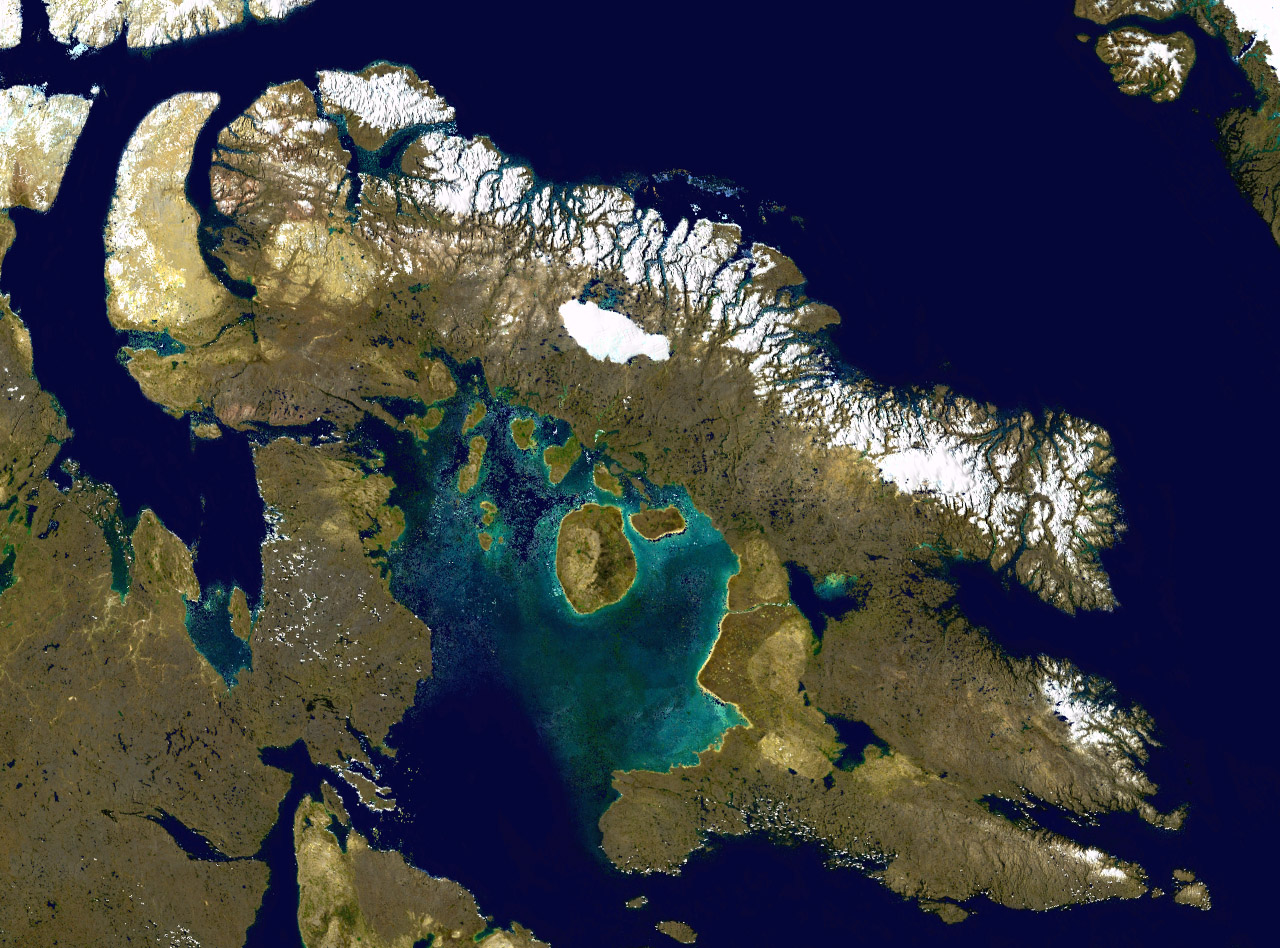
The archipelago extends some 2400 km longitudinally and 1900 km from the mainland to Cape Columbia, the northernmost point on Ellesmere Island. It is bounded on the west by the Beaufort Sea; on the northwest by the Arctic Ocean; on the east by Greenland, Baffin Bay and Davis Strait; and on the south by Hudson Bay and the Canadian mainland. The various islands are separated from each other and the continental mainland by a series of waterways collectively known as the Northwest Passage. Two large peninsulas, Boothia and Melville, extend northward from the mainland. The northernmost cluster of islands, including Ellesmere Island, is known as the Queen Elizabeth Islands and was formerly the Parry Islands.
The archipelago consists of 36,563 islands, of which 94 are classified as major islands, being larger than 130 km2, and cover a total area of 1400000 km2.
After Greenland, the archipelago is the world's largest high-Arctic land area. The climate of the islands is Arctic, and the terrain consists of tundra except in mountainous regions. Most of the islands are uninhabited; human settlement is extremely thin and scattered, being mainly coastal Inuit settlements on the southern islands.
Map with links to islands
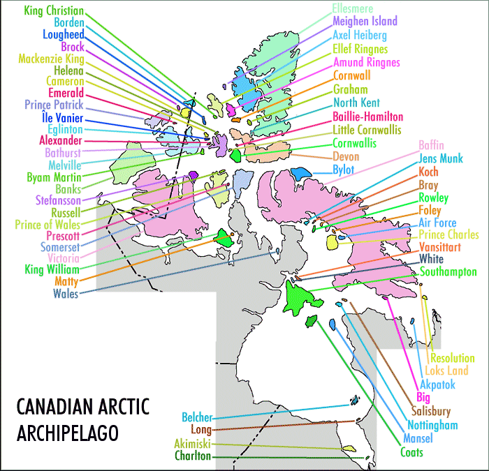
- King Christian
- Borden
- Lougheed
- Brock
- Mackenzie King
- Helena
- Cameron
- Emerald
- Prince Patrick
- Île Vanier
- Eglinton
- Alexander
- Bathurst
- Melville
- Byam Martin
- Banks
- Stefansson
- Russell
- Prince of Wales
- Prescott
- Somerset
- Victoria
- King William
- Matty
- Wales
- Belcher
- Long
- Akimiski
- Charlton
- Ellesmere
- Meighen
- Axel Heiberg
- Ellef Ringnes
- Amund Ringnes
- Cornwall
- Graham
- North Kent
- Baillie-Hamilton
- Little Cornwallis
- Cornwallis
- Devon
- Bylot
- Baffin
- Kapuiviit
- Koch
- Bray
- Rowley
- Foley
- Air Force
- Prince Charles
- Nagjuttuuq
- Qikiqtaaluk (Foxe Basin)
- Southampton
- Resolution
- Loks
- Akpatok
- Qikiqtarjuaq (Hudson Strait)
- Salisbury
- Nottingham
- Mansel
- Coats ;Islands not on map
- Beechey
- Broughton
- Cape Chidley
- Dorset
- Duke of York
- East Pen
- Flaherty
- Haig-Thomas
- Hans
- Herschel
- Igloolik
- Killiniq
- Ottawa
- Prince Leopold
- Qikiqtaryuaq
- Skraeling
- Trodely
- Umingmalik
- Weston
Notes
- Population: 183
- Formerly Jens Munk Island
- Formerly Vansittart Island
- Formerly White Island
- Formerly Big Island
- Population: 593
- Population: 1,396
- Population: 1,010
- Population: 2,049
- Formerly Jenny Lind Island
- Formerly Gateshead Island
Communities
| Community | Island | Region, territory | Population |
|---|---|---|---|
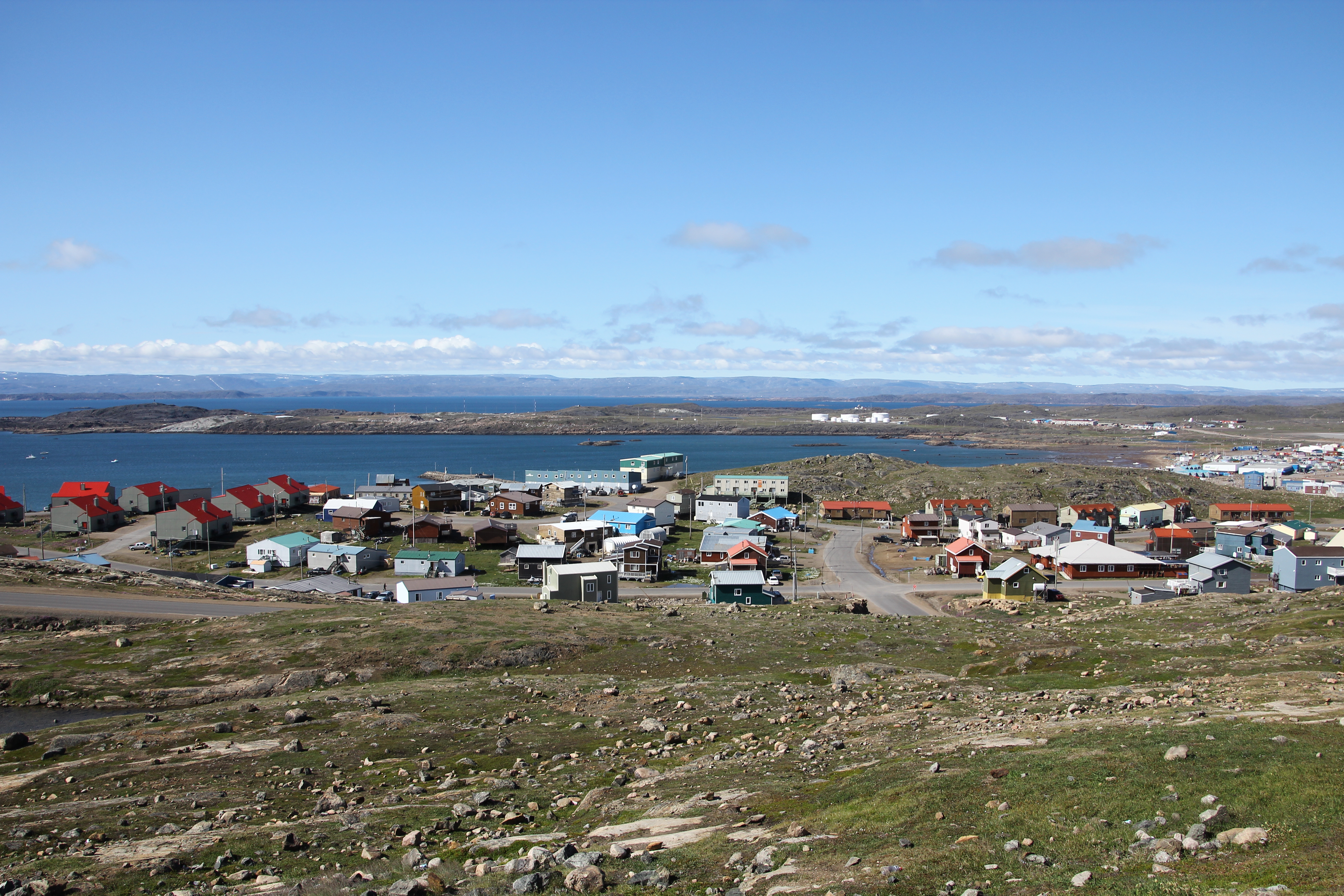
| Arctic Bay | Baffin Island | Qikiqtaaluk, NU | 944 |
| Clyde River | Baffin Island | Qikiqtaaluk, NU | 1,181 |
| Iqaluit | Baffin Island | Qikiqtaaluk, NU | 7,429 |
| Kimmirut | Baffin Island | Qikiqtaaluk, NU | 426 |
| Pangnirtung | Baffin Island | Qikiqtaaluk, NU | 1,504 |
| Pond Inlet | Baffin Island | Qikiqtaaluk, NU | 1,555 |
| Sachs Harbour | Banks Island | Inuvik, NT | 104 |
| Qikiqtarjuaq | Broughton Island | Qikiqtaaluk, NU | 593 |
| Resolute | Cornwallis Island | Qikiqtaaluk, NU | 183 |
| Kinngait | Dorset Island | Qikiqtaaluk, NU | 1,396 |
| Grise Fiord | Ellesmere Island | Qikiqtaaluk, NU | 144 |
| Sanikiluaq | Flaherty Island | Qikiqtaaluk, NU | 1,010 |
| Igloolik | Igloolik Island | Qikiqtaaluk, NU | 2,049 |
| Gjoa Haven | King William Island | Kitikmeot, NU | 1,349 |
| Coral Harbour | Southampton Island | Kivalliq, NU | 1,038 |
| Cambridge Bay | Victoria Island | Kitikmeot, NU | 1,760 |
| Ulukhaktok | Victoria Island | Inuvik, NT | 408 |
| Total | 23,073 |
Populated islands
Of the more than 36,000 islands, only 11 are populated. Baffin Island, the largest, also has the largest population of 13,309. The population accounts for 67.37 per cent of the 19,355 people in the Qikiqtaaluk Region, 56.51 per cent of the population of the Arctic Archipelago, and 35.38 per cent of the population of Nunavut.
| Island | Population | url=http://islands.unep.ch/Tiarea.htm | title=Islands By Land Area | publisher=Islands.unep.ch | access-date=27 May 2022 | archive-date=20 February 2018 | archive-url=https://web.archive.org/web/20180220003634/http://islands.unep.ch/Tiarea.htm}} | ||
|---|---|---|---|---|---|---|---|---|---|
| (km2) | Area | ||||||||
| (sq mi) | Density | ||||||||
| (km2) | Density | ||||||||
| (sq mi) | |||||||||
| Baffin Island | 13,039 | 507,451 | 507451 km | ||||||
| Banks Island | 104 | 70,028 | 70028 km | {{Pop density | 104 | 70028 | km2 | prec=3}} | |
| Broughton Island | 593 | 127.6 | 127.6 km | ||||||
| Cornwallis Island | 183 | 6,995 | 6995 km | ||||||
| Dorset Island | 1,396 | 8 sqmi | 8 | {{Pop density | 1396 | 8 | sqmi | flip=on | prec=3}} |
| Ellesmere Island | 144 | 196,236 | 196236 km | {{Pop density | 144 | 196236 | km2 | prec=3}} | |
| Flaherty Island | 1,010 | 1,585 | 1585 km | {{Pop density | 1010 | 1585 | km2 | prec=3}} | |
| Igloolik Island | 2,049 | 114.5 | 114.5 km | {{Pop density | 2049 | 114.5 | km2 | prec=3}} | |
| King William Island | 1,349 | 13,111 | 13111 km | {{Pop density | 1349 | 13111 | km2 | prec=3}} | |
| Southampton Island | 1,038 | 41,214 | 41214 km | {{Pop density | 1349 | 13111 | km2 | prec=3}} | |
| Victoria Island | 2,168 | 217,291 | 217291 km | {{Pop density | 2168 | 217291 | km2 | prec=3}} |
Mapping
- King Christian,
- Borden,
- Lougheed,
- Brock,
- Mackenzie King
- Helena,
- Cameron,
- Emerald Isle,
- Prince Patrick,
- Île Vanier,
- Eglinton,
- Alexander,
- Bathurst,
- Melville,
- Byam Martin,
- Banks,
- Stefansson,
- Russell,
- Prince of Wales,
- Prescott,
- Somerset,
- Victoria,
- King William,
- Matty,
- Wales,
- Belcher,
- Long,
- Akimiski,
- Charlton,
- Ellesmere,
- Meighen,
- Axel Heiberg,
- Ellef Ringnes,
- Amund Ringnes,
- Cornwall,
- Graham,
- North Kent,
- Baillie-Hamilton,
- Little Cornwallis,
- Cornwallis,
- Devon,
- Bylot,
- Baffin,
- Jens Munk,
- Koch,
- Bray,
- Rowley,
- Foley,
- Air Force,
- Prince Charles,
- Vansittart,
- White,
- Southampton,
- Resolution,
- Loks Land,
- Akpatok,
- Big,
- Salisbury,
- Nottingham,
- Mansel,
- Coats,
- Beechey,
- Broughton,
- Cape Chidley,
- Dorset,
- Duke of York,
- East Pen,
- Flaherty,
- Haig-Thomas,
- Hans,
- Herschel,
- Igloolik,
- Killiniq,
- Ottawa,
- Prince Leopold,
- Jenny Lind,
- Skraeling,
- Trodely,
- Gateshead,
- Weston,
References
References
- (12 August 2009). "Atlas of Canada – Sea Islands". Atlas.nrcan.gc.ca.
- Marsh, James H., ed. 1988. "[https://thecanadianencyclopedia.ca/en/article/arctic-archipelago Arctic Archipelago]" ''[[The Canadian Encyclopedia]]''. Toronto: Hurtig Publishers.
- [http://www.esrl.noaa.gov/psd/people/dezheng.sun/lectures/seaice/Rothrock-etal.1999-GRL.pdf Thinning of the Arctic Sea-Ice Cover]
- [http://amper.ped.muni.cz/jenik/dirs/gw/dirs/diagnosis/fig_cz/.w/stroeve_sea_ice2007.pdf Arctic sea ice decline: Faster than forecast]
- Wayman, Erin. "Canada's ice shrinking rapidly". [[Science News]].
- "Canada". World Statesmen.
- "Northwest Passage gets political name change". [[Edmonton Journal]].
- Levin, Dan. (7 November 2016). "Canada and Denmark Fight Over Island With Whisky and Schnapps". The New York Times.
- Bender, Jeremy. "2 countries have been fighting over an uninhabited island by leaving each other bottles of alcohol for over 3 decades".
- Hopper, Tristin. (13 June 2022). "Canada to get new land border with Denmark as decades-long Hans Island dispute ends". National Post.
- "Arctic Archipelago".
- "Islands By Land Area". Islands.unep.ch.
- "Sector13.Hudson Strait". pollux.nss.nima.mil.
- {{Cite cgndb. OACSS. Broughton Island
- {{cite cgndb. OADCZ. Cape Chidley Islands
- {{Cite cgndb. OAEOE. Dorset Island
- {{Cite cgndb. OAFRY. Flaherty Island
- {{Cite cgndb. OAHOZ. Igloolik Island
This article was imported from Wikipedia and is available under the Creative Commons Attribution-ShareAlike 4.0 License. Content has been adapted to SurfDoc format. Original contributors can be found on the article history page.
Ask Mako anything about Arctic Archipelago — get instant answers, deeper analysis, and related topics.
Research with MakoFree with your Surf account
Create a free account to save articles, ask Mako questions, and organize your research.
Sign up freeThis content may have been generated or modified by AI. CloudSurf Software LLC is not responsible for the accuracy, completeness, or reliability of AI-generated content. Always verify important information from primary sources.
Report