From Surf Wiki (app.surf) — the open knowledge base
Andover, Maine
Town in the state of Maine, United States

Town in the state of Maine, United States
| Field | Value | |
|---|---|---|
| name | Andover, Maine | |
| settlement_type | Town | |
| image_skyline | Main Street, Andover, ME.jpg | |
| image_caption | Main Street | |
| image_seal | Andover_Maine_Seal.png | |
| pushpin_map | Maine#USA#North America | |
| pushpin_label_position | right | |
| pushpin_map_caption | Location within the state of Maine | |
| subdivision_type | Country | |
| subdivision_name | United States | |
| subdivision_type1 | State | |
| subdivision_name1 | Maine | |
| subdivision_type2 | County | |
| subdivision_name2 | Oxford | |
| established_title | Incorporated | |
| established_date | 1804 | |
| unit_pref | Imperial | |
| area_footnotes | ||
| area_total_km2 | 148.82 | |
| area_land_km2 | 148.72 | |
| area_water_km2 | 0.10 | |
| area_total_sq_mi | 57.46 | |
| area_land_sq_mi | 57.42 | |
| area_water_sq_mi | 0.04 | |
| population_as_of | 2020 | |
| population_footnotes | ||
| population_total | 752 | |
| population_density_km2 | 5.5 | |
| population_density_sq_mi | 14.3 | |
| timezone | Eastern (EST) | |
| utc_offset | -5 | |
| timezone_DST | EDT | |
| utc_offset_DST | -4 | |
| elevation_m | 204 | |
| elevation_ft | 669 | |
| coordinates | ||
| postal_code_type | ZIP Codes | |
| postal_code | 04216 (Andover) | |
| 04226 (East Andover) | ||
| area_code | 207 | |
| blank_name | FIPS code | |
| blank_info | 23-01325 | |
| blank1_name | GNIS feature ID | |
| blank1_info | 0582325 | |
| website |
04226 (East Andover)
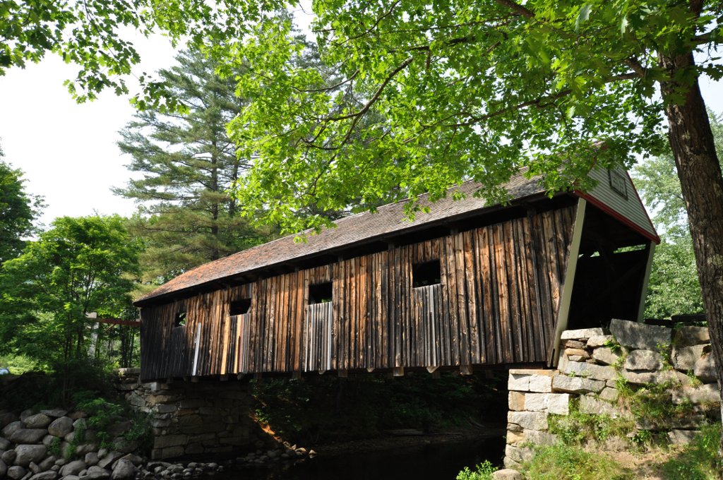
Andover is a town in Oxford County, Maine, United States. The population was 752 at the 2020 census. Set among mountains and crossed by the Appalachian Trail, Andover is home to the Lovejoy Covered Bridge and is the site of the Andover Earth Station.
History
The land which became known as Andover was originally purchased in 1788 by a group of proprietors mostly from Andover, Massachusetts. The original proprietors were Jonathan Abbot, Philip Abbott, Ebenezer Adams, Ingalls Bragg, Samuel Farnum, Samuel Johnson, Abiel Lovejoy, Benjamin Poor, Eben Poor, Jr., and Theodore Stevens, all of Andover, Massachusetts; John York of Bethel, Massachusetts; Joseph Frye of Fryeburg, Massachusetts; and Josiah Bean, Ezekiel Merrill, and Thomas Poor of Methuen, Massachusetts. The town was first settled in 1789 by Ezekiel Merrill and his family who were transported there from Bethel, Maine, in canoes managed by members of the local Pequawket tribe. The first saw-mill was built on the East Branch of the Ellis River by Col. Thomas Poor in 1791 and was used to provide the lumber for the still standing Merrill-Poor House.
The town was incorporated on June 23, 1804, as East Andover, and then renamed Andover in 1820 when Maine separated from Massachusetts.
Occupations for early inhabitants primarily included agriculture and lumbering. As the town developed, local factories made doors, sash, blinds, starch, cheese, boots, shoes, edge-tools, carriages, and harness. The town also had a tannery. Located on an intervale surrounded by mountains, Andover is noted for "its grand and beautiful scenery," with streams abounding in trout. After the Civil War, the town became a popular destination for sportsmen, especially fishermen attracted by the nearby Richardson Lakes. A hotel was built to accommodate the influx of tourists.{{Citation | archive-url = https://archive.today/20130201023922/http://history.rays-place.com/me/andover-me.htm | url-status = dead | archive-date = February 1, 2013
In 1960, Andover was selected to be site of the Andover Earth Station, completed in 1962. It was the location of the first live transatlantic television signal broadcast by satellite Telstar 1.
Geography
According to the United States Census Bureau, the town has a total area of 57.46 sqmi, of which 57.42 sqmi is land and 0.04 sqmi is water. Crossed by the Appalachian Trail, Andover is drained by the Ellis River, a tributary of the Androscoggin River. The river is home to many fish and wildlife, from which avid hunters and fisherman try their luck.
The town is crossed by state routes 5 and 120. It borders the towns of Roxbury and Byron to the east, Rumford to the south, Newry to the southwest, Andover West Surplus to the west, and Andover North Surplus to the north.
Climate
This climatic region is typified by large seasonal temperature differences, with warm to hot (and often humid) summers and cold (sometimes severely cold) winters. According to the Köppen Climate Classification system, Andover has a humid continental climate, abbreviated "Dfb" on climate maps.
| Jan record high F = 54 | Feb record high F = 68 | Mar record high F = 77 | Apr record high F = 89 | May record high F = 92 | Jun record high F = 95 | Jul record high F = 97 | Aug record high F = 94 | Sep record high F = 94 | Oct record high F = 83 | Nov record high F = 75 | Dec record high F = 59 | year record high F =
|Jan avg record high F = 45.3 |Feb avg record high F = 47.1 |Mar avg record high F = 55.8 |Apr avg record high F = 74.4 |May avg record high F = 84.4 |Jun avg record high F = 87.1 |Jul avg record high F = 89.6 |Aug avg record high F = 87.2 |Sep avg record high F = 83.6 |Oct avg record high F = 72.9 |Nov avg record high F = 62.4 |Dec avg record high F = 48.8 |year avg record high F = 91.9
|Jan avg record low F = -12.9 |Feb avg record low F = -9.9 |Mar avg record low F = -6.0 |Apr avg record low F = 17.2 |May avg record low F = 27.2 |Jun avg record low F = 37.3 |Jul avg record low F = 43.6 |Aug avg record low F = 40.6 |Sep avg record low F = 29.7 |Oct avg record low F = 22.5 |Nov avg record low F = 9.8 |Dec avg record low F = -5.1 |year avg record low F = -14.9
| Jan record low F = -30 | Feb record low F = -20 | Mar record low F = -16 | Apr record low F = 8 | May record low F = 23 | Jun record low F = 28 | Jul record low F = 39 | Aug record low F = 35 | Sep record low F = 26 | Oct record low F = 13 | Nov record low F = 0 | Dec record low F = -17 | year record low F =
|access-date = October 26, 2023 |access-date = October 26, 2023
Demographics
2010 census
As of the census of 2010, there were 821 people, 385 households, and 253 families living in the town. The population density was 14.3 PD/sqmi. There were 603 housing units at an average density of 10.5 /sqmi. The racial makeup of the town was 98.8% White, 0.4% Native American, 0.4% Asian, and 0.5% from two or more races.
There were 385 households, of which 20.5% had children under the age of 18 living with them, 52.5% were married couples living together, 7.8% had a female householder with no husband present, 5.5% had a male householder with no wife present, and 34.3% were non-families. 28.3% of all households were made up of individuals, and 12.7% had someone living alone who was 65 years of age or older. The average household size was 2.13 and the average family size was 2.57.
The median age in the town was 51.1 years. 15.6% of residents were under the age of 18; 4.7% were between the ages of 18 and 24; 20.5% were from 25 to 44; 35.3% were from 45 to 64; and 23.9% were 65 years of age or older. The gender makeup of the town was 50.7% male and 49.3% female.
2000 census
As of the census of 2000, there were 864 people, 359 households, and 257 families living in the town. The population density was 15.1 PD/sqmi. There were 553 housing units at an average density of 9.6 /sqmi. The racial makeup of the town was 98.96% White, 0.46% African American, 0.12% Native American, 0.12% from other races, and 0.35% from two or more races. Hispanic or Latino of any race were 0.35% of the population.
There were 359 households, out of which 27.6% had children under the age of 18 living with them, 61.8% were married couples living together, 5.8% had a female householder with no husband present, and 28.4% were non-families. 23.4% of all households were made up of individuals, and 9.2% had someone living alone who was 65 years of age or older. The average household size was 2.41 and the average family size was 2.81.
In the town, the population was spread out, with 23.3% under the age of 18, 3.5% from 18 to 24, 28.0% from 25 to 44, 30.7% from 45 to 64, and 14.6% who were 65 years of age or older. The median age was 42 years. For every 100 females, there were 99.5 males. For every 100 females age 18 and over, there were 100.3 males.
The median income for a household in the town was $36,058, and the median income for a family was $40,855. Males had a median income of $32,031 versus $20,000 for females. The per capita income for the town was $20,253. About 9.0% of families and 12.2% of the population were below the poverty line, including 18.3% of those under age 18 and 13.3% of those age 65 or over.
Sites of interest
- Andover Earth Station
- Andover Elementary School
- Andover Hook and Ladder Company Building
- Andover Public Library
- East Andover
- Lovejoy Bridge
- Merrill-Poor House
Notable people
· Only people who already have a Wikipedia article may appear here. This establishes notability. · The article must mention how they are associated with Andover, whether born, raised, or residing. · The fact of their association should have a reliable source cited. · Alphabetical by last name please · All others will be deleted without further explanation
- Charlie Akers, Olympic biathlete
- Robert W. Duplessie, politician
- Molly Ockett, Abenaki healer
- John Orville Newton, principal and politician
- Henry Varnum Poor, financial analyst
- John A. Poor, lawyer, editor, and entrepreneur
References
References
- (August 13, 1904). "History of Andover Maine, Purchase of the township and distribution of the land". The Rumford Falls Times.
- Maine League of Historical Societies and Museums. (1970). "Maine: A Guide 'Down East'". Courier-Gazette, Inc..
- "US Gazetteer files 2010". [[United States Census Bureau]].
- [http://www.weatherbase.com/weather/weather-summary.php3?s=162571&cityname=Andover%2C+Maine%2C+United+States+of+America&units= Climate Summary for Andover, Maine]
- "Annual Estimates of the Resident Population for Incorporated Places: April 1, 2010 to July 1, 2014".
- "Census of Population and Housing". Census.gov.
- "U.S. Census website". [[United States Census Bureau]].
- "U.S. Census website". [[United States Census Bureau]].
This article was imported from Wikipedia and is available under the Creative Commons Attribution-ShareAlike 4.0 License. Content has been adapted to SurfDoc format. Original contributors can be found on the article history page.
Ask Mako anything about Andover, Maine — get instant answers, deeper analysis, and related topics.
Research with MakoFree with your Surf account
Create a free account to save articles, ask Mako questions, and organize your research.
Sign up freeThis content may have been generated or modified by AI. CloudSurf Software LLC is not responsible for the accuracy, completeness, or reliability of AI-generated content. Always verify important information from primary sources.
Report