From Surf Wiki (app.surf) — the open knowledge base
Allegheny County, Pennsylvania
County in Pennsylvania, United States
County in Pennsylvania, United States
| Field | Value |
|---|---|
| county | Allegheny County |
| state | Pennsylvania |
| seal | Seal of Allegheny County, Pennsylvania.svg |
| seal size | 95px |
| flag | Flag of Allegheny County, Pennsylvania.svg |
| flag size | 105px |
| logo | AlleghenyCountyPAlogo.png |
| logo size | 90px |
| founded year | 1788 |
| founded date | September 24 |
| seat wl | Pittsburgh |
| largest city wl | Pittsburgh |
| area_total_sq_mi | 745 |
| area_land_sq_mi | 730 |
| area_water_sq_mi | 14 |
| area percentage | 1.9% |
| census yr | 2020 |
| pop | 1250578 |
| pop_est_as_of | 2024 |
| population_est | 1231814 |
| pop_est_footnotes | |
| density_sq_mi | 1700 |
| time zone | Eastern |
| website | |
| named for | Allegheny River |
| ex image | Allegheny County Courthouse & Jail - Court of Common Pleas (9551537268).jpg |
| ex image size | 250px |
| ex image cap | Allegheny County Courthouse |
| mapframe | yes |
| district | 12th |
| district2 | 17th |
| footnotes |
Allegheny County ( ) is a county in Pennsylvania, United States. As of the 2020 census, the population was 1,250,578, making it the state's second-most populous county, after Philadelphia County. Its county seat and most populous city is Pittsburgh, Pennsylvania's second most populous city. The county is part of the Greater Pittsburgh region of the commonwealth, and is the center of the Pittsburgh media market.
Allegheny was the first county in Pennsylvania to be given a Native American name. It was named after the Lenape word for the Allegheny River. The meaning of "Allegheny" is uncertain. It is usually said to mean "fine river". Some historians state that the name may come from a Lenape account of an ancient mythical tribe called "Allegewi" who lived along the river before being taken over by the Lenape.
History

Prior to European contact, this area was settled for thousands of years by succeeding cultures of indigenous peoples. During the colonial era, historic native groups known by the colonists to settle in the area included members of western nations of the Iroquois, such as the Seneca; the Lenape, who had been pushed from the East by European-American settlers; the Shawnee, who also had territory in Ohio; and the Mingo, a group made up of a variety of peoples from more eastern tribes.
European fur traders such as Peter Chartier established trading posts in the region in the early eighteenth century.
In 1749, Captain Pierre Joseph Céloron de Blainville claimed the Ohio Valley and all of western Pennsylvania for King Louis XV of France. The captain traveled along the Ohio and Allegheny rivers. He installed lead plates in the ground to mark the land for France.
Most of the towns during that era were developed along waterways, which were the primary transportation routes, as well as providing water for domestic uses. Through the eighteenth century, both the French and the British competed for control over the local rivers in this frontier territory of North America. Native American bands and tribes allied with the colonists to differing degrees, often based on their trading relationships. The British sent Major George Washington to expel the French from their posts, with no success. He also nearly drowned in the ice-filled Allegheny River while returning to camp.
The English tried again in 1754 to establish a post in the area. They sent 41 Virginians to build Fort Prince George. The French learned of the plan and sent an army to capture the fort. They resumed building it and added increased defensive fortification, renaming it as Fort Duquesne.
Given its strategic location at the Ohio, Fort Duquesne became an important focal point of the French and Indian War. The first British attempt to retake the fort, the Braddock Expedition, failed miserably. In 1758 British forces under General John Forbes recaptured the fort; he had it destroyed to prevent any use by the French. The British built a new, larger fort on the site, including a moat, and named it Fort Pitt. The historic site has been preserved as Pittsburgh's Point State Park.
Under their colonial charters, both Pennsylvania and Virginia claimed the region that is now Allegheny County. Pennsylvania administered most of the region as part of its Westmoreland County. Virginia considered everything south of the Ohio River and east of the Allegheny River to be part of its Yohogania County, and governed it from Fort Dunmore. In addition, parts of the county were located in the proposed British colony of Vandalia and the proposed U.S. state of Westsylvania. The overlapping boundaries, multiple governments, and confused deed claims soon proved unworkable. Near the end of the American Revolutionary War, in 1780 Pennsylvania and Virginia agreed to extend the Mason–Dixon line westward. This region was assigned to Pennsylvania. From 1781 until 1788, much of what Virginia had claimed as part of Yohogania County was administered as a part of the newly created Washington County, Pennsylvania.
Allegheny County was officially created on September 24, 1788, from parts of Washington and Westmoreland counties. It was formed to respond to pressure from the increase in settlers living in the area around Pittsburgh; this was designated as the county seat in 1791. The county originally extended north to the shores of Lake Erie; it was reduced to its current borders by 1800. As population increased in the territory, other counties were organized.
In the 1790s, the United States federal government imposed a whiskey excise tax. Farmers who had depended on whiskey income refused to pay and started the so-called Whiskey Rebellion after driving off tax collector John Neville. After a series of demonstrations by farmers, President George Washington sent troops to suppress the frontier rebellion.
The area developed rapidly through the 1800s with industrialization. It became the nation's prime steel producer by the late 19th century and Pittsburgh was nicknamed "Steel Capital of the World".
In 1913, the county's 125th anniversary was celebrated with a week-long series of events. The final day, September 27, was marked by a steamboat parade of 30 paddle wheelers. They traveled from Monongahela Wharf down the Ohio to the Davis Island Dam. The boats in line were the Steel City (formerly the Pittsburgh and Cincinnati packet Virginia), the flag ship; City of Parkersburg, Charles Brown, Alice Brown, Exporter, Sam Brown, Boaz, Raymond Horner, Swan, Sunshine, I. C. Woodward, Cruiser, Volunteer, A. R. Budd, J. C. Risher, Clyde, Rival, Voyager, Jim Brown, Rover, Charlie Clarke, Robt. J. Jenkins, Slipper, Bertha, Midland Sam Barnum, Cadet, Twilight, and Troubadour.
Geography
According to the U.S. Census Bureau, the county has a total area of 745 sqmi, of which 730 sqmi is land and 14 sqmi (1.9%) is water.
Four major rivers traverse Allegheny County: the Allegheny River and the Monongahela River converge at Downtown Pittsburgh to form the Ohio River. The Youghiogheny River flows into the Monongahela River at McKeesport, 10 mi to the southeast. There are several islands in these courses. The rivers drain via the Mississippi River into the Gulf of Mexico. Although the county's industrial growth resulted in clearcutting of the area's forests, a significant amount of woodland has regrown.
Adjacent counties
- Butler County (north)
- Armstrong County (northeast)
- Westmoreland County (east and south)
- Washington County (southwest)
- Beaver County (northwest)
Major roads and highways
Climate
Allegheny has a humid continental climate which is hot-summer, (Dfa) except in higher elevations, where it is warm-summer (Dfb).
Government and politics

Until January 1, 2000, Allegheny County's government was defined under Pennsylvania's Second Class County Code. The county government was charged with all local activities, including elections, prisons, airports, public health, and city planning. All public offices were headed by elected citizens. There were three elected county commissioners.
On January 1, 2000, the Home-Rule Charter went into effect. It replaced the three elected commissioners with an elected chief officer (the County Executive), a county council with 15 members (13 elected by district, two elected county-wide), and an appointed county manager. The changes were intended to maintain a separation of powers between the executive and legislative branches while providing greater citizen control.
The county has 130 self-governing municipalities, the most in the state. (Luzerne is second with 76). The county has one Second Class City (Pittsburgh) and three Third Class Cities (Clairton, Duquesne, and McKeesport).
A 2004 study found the county would be better served by consolidating the southeastern portion of the county (which includes many small communities with modest economies) into a large municipality ("Rivers City") with a combined population of approximately 250,000.
Government structure
Allegheny County has a Home Rule Charter form of government since 2000. The county has three branches: the executive, the legislative, and the judicial. The executive branch consists of the County Executive, who is elected for a four-year term and serves as the chief executive officer of the county; and the County Manager, who is appointed by the County Executive and oversees the daily operations of the county departments. The current County Executive is Sara Innamorato, a Democrat who took office in 2024. The current County Manager is William D. McKain, who was appointed by then-County Executive Rich Fitzgerald in 2012 and reappointed in 2016 and 2020. The legislative branch consists of the County Council, which is composed of 15 members elected for four-year terms from 13 single-member districts and 2 At-Large representatives, currently occupied by Bethany Hallam and Sam DeMarco. The council functions as the primary legislative and policy-making body of the county. The current County Council President is Patrick Catena, a Democrat who represents District 4 and was elected by his fellow council members in 2018 and 2020. The judicial branch consists of the Court of Common Pleas, which is the general trial court of the county; and the Magisterial District Courts, which are lower courts that handle minor criminal and civil cases. The judges of these courts are elected for ten-year terms. The current President Judge of the Court of Common Pleas is Kimberly Berkeley Clark, who was elected by her fellow judges in 2018 for a five-year term.
Self-governing municipalities
Allegheny County has 130 self-governing municipalities, the most in the state. These include one city (Pittsburgh), 96 boroughs, 30 townships, and two home rule municipalities (Bethel Park and McCandless). Each municipality has its own elected officials, such as mayor, council, commissioners, supervisors, etc., and its own local services, such as police, fire, public works, etc. Some municipalities also have their own municipal authorities that provide services such as water, sewer, transit, etc.
Changes to Administrative Divisions
There have been several proposals to consolidate or merge some of the municipalities in Allegheny County, either with each other or with the City of Pittsburgh, to reduce costs, improve efficiency, and enhance regional cooperation. However, none of these proposals have been implemented so far. One of the most recent proposals is from Wilkinsburg, a borough that borders Pittsburgh and faces financial challenges due to declining population and tax base. In 2020, Wilkinsburg residents voted to approve a referendum to explore a merger with Pittsburgh. In 2021, a joint task force was formed to study the feasibility and impact of such a merger. The task force is expected to issue a report by June 2022. If both Wilkinsburg and Pittsburgh councils approve the merger, it would then need approval from the state legislature and governor before taking effect. Another recent proposal is from Allegheny County Economic Development (ACED), which is seeking to enter into an agreement with a consultant to carry out historic preservation compliance activities for projects funded by various federal programs. The consultant would help ACED develop a Programmatic Memorandum of Agreement (PMOA) with the Pennsylvania State Historic Preservation Office (SHPO) and other stakeholders to streamline the review process for projects that may affect historic properties within the county. ACED issued a Request for Proposals (RFP) for this service in January 2022 and expects to select a consultant by March 2022.
County Executive
- Sara Innamorato (D)
County Council
- Bethany Hallam (D), At-Large Member
- Alex Rose (I), At-Large Member
- Kathleen Madonna-Emmerling (D), District 1
- Suzanne Filiaggi (R), District 2
- Lissa Geiger Shulman (D), District 3
- Patrick Catena (D), President, District 4
- Dan Grzybek (D), District 5
- John F. Palmiere (D), Vice President, District 6
- Nicholas Futules (D), District 7
- Michelle Naccarati-Chapkis (D), District 8
- Aaron Adams (D), District 9
- DeWitt Walton (D), District 10,
- Paul Klein (D), District 11
- Robert Palmosina (D), District 12
- Jordan Botta (D), District 13
Other elected county offices
- Controller, Amy Weise Clements (Acting)
- District Attorney, Stephen A. Zappala Jr. (Forward)
- Sheriff, Kevin M. Kraus (D)
- Treasurer, Erica Rocchi Brusselars (D)
Voter registration

there were 908,024 registered voters in the county; a majority were Democrats. There were 499,711 registered Democrats, 264,342 registered Republicans, 106,334 registered as independents and 37,637 registered with other parties.
| Voter registration and party enrollment | Party | Number of voters | Percentage | Total | 908,024 | 100% |
|---|---|---|---|---|---|---|
| Democratic | 499,711 | 55.03% | ||||
| Republican | 264,342 | 29.11% | ||||
| Independent | 106,334 | 11.71% | ||||
| Other parties | 37,637 | 4.14% |
Political history
The Republican Party had been historically dominant in county-level politics in the 19th and early 20th centuries; prior to the Great Depression, Pittsburgh and Allegheny County had been majority Republican. Since the Great Depression on the state and national levels, the Democratic Party has been dominant in county-level politics. It is by far the most Democratic county in western Pennsylvania. For much of the time between the Great Depression and the turn of the millennium, it was the second-strongest Democratic bastion in Pennsylvania, behind only Philadelphia.
In 2000, Democrat Al Gore won 56% of the vote and Republican George W. Bush won 41%. In 2004, Democrat John Kerry received 57% of the vote and Republican Bush received 41%. In 2006, Democrats Governor Ed Rendell and Senator Bob Casey Jr. won 59% and 65% of the vote in Allegheny County, respectively. In 2008, Democrat Barack Obama received 57% of the vote, Republican John McCain received 41%, and each of the three state row office winners (Rob McCord for Treasurer, Jack Wagner for Auditor General, and Tom Corbett for Attorney General) also carried Allegheny. In 2016, despite Donald Trump being the first Republican to carry Pennsylvania since 1988, Hillary Clinton did slightly better than Barack Obama's 2012 vote total while Donald Trump was the worst performing Republican in 20 years. In the 2018 Midterms, Democrats received an even higher percentage of the vote with Tom Wolf and Casey receiving approximately two thirds of the county's vote. This is an improvement over the approximately 55% each person received in the county in their last election in 2014 and 2012 respectively. In 2020, Joe Biden improved upon Clinton's performance, receiving the highest vote percentage for a Democrat since Michael Dukakis in 1988 and the most votes for a Democrat since Lyndon B. Johnson in 1964.
In the 21st century, populist turns to the GOP from nearly all of Appalachia in general and western Pennsylvania in particular have left the county as one of the few in the region that still supports the Democrats at a high level.
State representatives
Source
- Aerion Abney, Democratic, 19th district
- Emily Kinkead, Democratic, 20th district
- Lindsay Powell, Democratic, 21st district
- Dan Frankel, Democratic, 23rd district
- La'Tasha Mayes, Democratic, 24th district
- Brandon Markosek, Democratic, 25th district
- Daniel J. Deasy, Democratic, 27th district
- Jeremy Shaffer, Republican, 28th district
- Arvind Venkat, Democratic, 30th district
- Joe McAndrew, Democratic, 32nd district
- Mandy Steele, Democratic, 33rd district
- Abigail Salisbury, Democratic, 34th district
- Dan Goughnour, Democratic, 35th district
- Jessica Benham, Democratic, 36th district
- John Inglis, Democratic, 38th district
- Andrew Kuzma, Republican, 39th district
- Natalie Mihalek, Republican, 40th district
- Vacant, 42nd district
- Valerie Gaydos, Republican, 44th district
- Anita Astorino Kulik, Democratic, 45th district
- Jason Ortitay, Republican, 46th district
State senators
- Devlin Robinson, Republican, 37th district
- Lindsey Williams, Democrat, 38th district
- Wayne D. Fontana, Democrat, 42nd district
- Jay Costa, Democrat, 43rd district
- Nick Pisciottano, Democrat, 45th district
U.S. representatives
- Chris Deluzio, Democrat, 17th district
- Summer Lee, Democrat, 12th district
U.S. Senate
- John Fetterman, Democratic
- Dave McCormick, Republican
P.A. Governor
Religion
In 2010 statistics, the largest religious group in Allegheny County was the Roman Catholic Diocese of Pittsburgh, with 460,672 Catholics worshipping at 179 parishes; followed by the United Methodist Church, with 44,204 Methodists in 100 congregations; the Presbyterian Church in the United States of America, with 42,838 Presbyterians in 145 congregations; non-denominational Protestants, with 33,103 adherents in 85 congregations; the Evangelical Lutheran Church in America, with 24,718 Lutherans in 77 congregations; the American Baptist Churches USA, with 17,148 Baptists in 42 congregations; the Assemblies of God, with 12,398 Pentecostals in 30 congregations; Reform Judaism, with 8,483 Jews in 6 congregations; the 7,780 Episcopal Church (United States), with 7,780 Episcopalians in 19 congregations; and Hinduism in the United States, with 6,700 Hindus in four temples. Altogether, 60.6% of the population was claimed as members by religious congregations, although members of historically African-American denominations were underrepresented due to incomplete information. In 2014, Allegheny County had 794 religious organizations, the 11th most out of all US counties.
Demographics
| align-fn = center 1790–1960 1900–1990 1990–2000 2010–2018
2020 census
As of the 2020 census, the county had a population of 1,250,578. The median age was 40.2 years. 18.4% of residents were under the age of 18 and 19.4% of residents were 65 years of age or older. For every 100 females there were 94.1 males, and for every 100 females age 18 and over there were 91.8 males age 18 and over.
The racial makeup of the county was 75.7% White, 13.1% Black or African American, 0.2% American Indian and Alaska Native, 4.7% Asian,
97.6% of residents lived in urban areas, while 2.4% lived in rural areas.
There were 551,013 households in the county, of which 23.2% had children under the age of 18 living in them. Of all households, 40.3% were married-couple households, 21.4% were households with a male householder and no spouse or partner present, and 31.4% were households with a female householder and no spouse or partner present. About 35.7% of all households were made up of individuals and 14.2% had someone living alone who was 65 years of age or older.
There were 602,095 housing units, of which 8.5% were vacant. Among occupied housing units, 62.5% were owner-occupied and 37.5% were renter-occupied. The homeowner vacancy rate was 1.5% and the rental vacancy rate was 7.8%.
| Race / Ethnicity (NH = Non-Hispanic) | title=P004: Hispanic or Latino, and Not Hispanic or Latino by Race – 2000: DEC Summary File 1 – Allegheny County, Pennsylvania | url=https://data.census.gov/table/DECENNIALSF12000.P004?q=P004:+HISPANIC+OR+LATINO,+AND+NOT+HISPANIC+OR+LATINO+BY+RACE+[73]&g=050XX00US42003 | publisher=United States Census Bureau | access-date= }} | title=P2 Hispanic or Latino, and Not Hispanic or Latino by Race – 2010: DEC Redistricting Data (PL 94-171) - Allegheny County, Pennsylvania | url=https://data.census.gov/table/DECENNIALPL2010.P2?q=p2&g=050XX00US42003 | website=United States Census Bureau}} | % 2000 | % 2010 |
|---|---|---|---|---|---|---|---|---|---|
| White alone (NH) | 1,074,129 | 986,212 | 938,252 | 83.80% | |||||
| Black or African American alone (NH) | 158,049 | 159,998 | 161,554 | 12.33% | |||||
| Native American or Alaska Native alone (NH) | 1,427 | 1,426 | 1,305 | 0.11% | |||||
| Asian alone (NH) | 21,635 | 33,944 | 58,318 | 1.68% | |||||
| Pacific Islander alone (NH) | 296 | 251 | 304 | 0.02% | |||||
| Other race alone (NH) | 2,339 | 2,098 | 6,064 | 0.18% | |||||
| Mixed race or Multiracial (NH) | 12,625 | 20,349 | 50,456 | 0.98% | |||||
| Hispanic or Latino (any race) | 11,166 | 19,070 | 34,325 | 0.87% | |||||
| Total | 1,281,666 | 1,223,348 | 1,250,578 | 100.00% |
2010 census
As of the 2010 census, there were 1,223,348 people living in the county. The population density was 1676 /mi2. The racial makeup of the county was 82.87% White, 14.39% Black or African American, 2.94% Asian, 0.03% Pacific Islander, 0.37% from other races, and 1.40% from two or more races. About 1.31% of the population were Hispanic or Latino of any race.
2000 census
At the 2000 census, there were 1,281,666 people, 537,150 households, and 332,495 families living in the county. The population density was 1,755 /mi2. There were 583,646 housing units at an average density of 799 /mi2. The racial makeup of the county was 84.33% White, 12.41% Black or African American, 0.12% Native American, 1.69% Asian, 0.03% Pacific Islander, 0.34% from other races, and 1.07% from two or more races. About 0.87% of the population were Hispanic or Latino of any race. 20.0% were of German, 15.0% Italian, 12.7% Irish, 7.5% Polish and 5.1% English ancestry. 93.5% spoke English and 1.3% Spanish as their first language.
There were 537,150 households, out of which 26.40% had children under the age of 18 living with them, 46.10% were married couples living together, 12.40% had a female householder with no husband present, and 38.10% were non-families. Some 32.70% of all households were made up of individuals, and 13.20% had someone living alone who was 65 years of age or older. The average household size was 2.31 and the average family size was 2.96.
The age distribution of the population shows 21.90% under the age of 18, 8.50% from 18 to 24, 28.30% from 25 to 44, 23.40% from 45 to 64, and 17.80% who were 65 years of age or older. The median age was 40. For every 100 females, there were 90.00 males; for every 100 females age 18 and over, there were 86.20 males.
Economy
In the late 18th century, farming played a critical role in the growth of the area. There was a surplus of grain due to transportation difficulties in linking with the eastern portion of the state. As a result, the farmers distilled the grain into whiskey, which significantly helped the farmers financially.
.svg)
The area quickly became a key manufacturing area in the young nation. Coupled with deposits of iron and coal, and the easy access to waterways for barge traffic, the city quickly became one of the most important steel producing areas in the world. Based on 2007 data from the US Army Corps of Engineers, Pittsburgh is the second (after Laredo, Texas) busiest inland port in the nation.
US steel production declined late in the 20th century, and Allegheny County's economy began a shift to other industries. It is presently known for its hospitals, universities, and industrial centers. Despite the decline of heavy industry, Pittsburgh is home to a number of major companies and is ranked in the top ten among US cities hosting headquarters of Fortune 500 corporations, including U.S. Steel Corporation, PNC Financial Services Group, PPG Industries, and H. J. Heinz Company.
The county leads the state in number of defense contractors supplying the U.S. military.
Regions
- East Hills
- North Hills
- South Hills
- West Hills
- City of Pittsburgh
Education
Colleges and universities
- Byzantine Catholic Seminary of SS. Cyril and Methodius
- Carlow University
- Carnegie Mellon University
- Chatham University
- DeVry University
- Duquesne University
- La Roche University
- Penn State Greater Allegheny
- Pittsburgh Theological Seminary
- Point Park University
- Reformed Presbyterian Theological Seminary
- Robert Morris University
- University of Pittsburgh
Community, junior and technical colleges
- Bidwell Training Center
- Community College of Allegheny County
- Empire Beauty Schools
- Fountain of Youth Academy of Cosmetology
- Institute of Medical and Business Careers
- North Hills Beauty Academy
- Pittsburgh Career Institute
- Pittsburgh Institute of Aeronautics
- Pittsburgh Institute of Mortuary Science
- Pittsburgh Multicultural Cosmetology Academy
- Pittsburgh Technical College
- Rosedale Technical College
- South Hills Beauty Academy
- Triangle Tech
- Vet Tech Institute
Public school districts

School districts include:
- Allegheny Valley School District
- Avonworth School District
- Baldwin-Whitehall School District
- Bethel Park School District
- Brentwood Borough School District
- Carlynton School District
- Chartiers Valley School District
- Clairton City School District
- Cornell School District
- Deer Lakes School District
- Duquesne City School District
- East Allegheny School District
- Elizabeth Forward School District
- Fort Cherry School District (part)
- Fox Chapel Area School District
- Gateway School District
- Hampton Township School District
- Highlands School District
- Keystone Oaks School District
- McKeesport Area School District
- Montour School District
- Moon Area School District
- Mount Lebanon School District
- North Allegheny School District
- North Hills School District
- Northgate School District
- Norwin School District
- Penn Hills School District
- Penn-Trafford School District (part)
- Pine-Richland School District
- Pittsburgh School District
- Plum Borough School District
- Quaker Valley School District
- Riverview School District
- Shaler Area School District
- South Allegheny School District
- South Fayette Township School District
- South Park School District
- Steel Valley School District
- Sto-Rox School District
- Upper St. Clair School District
- West Allegheny School District
- West Jefferson Hills School District
- West Mifflin Area School District
- Wilkinsburg School District
- Woodland Hills School District
Approved private schools
These private schools provide special education for disabled students:
- ACLD Tillotson School, Pittsburgh
- The Day School at The Children's Institute, Pittsburgh
- DePaul School for Hearing and Speech, Pittsburgh
- Easter Seal Society of Western Pennsylvania
- The Education Center at the Watson Institute, Sewickley
- Pace School, Pittsburgh
- Pressley Ridge Day School, Pittsburgh
- Pressley Ridge School for the Deaf, Pittsburgh
- The Watson Institute Friendship Academy, Pittsburgh
- Wesley Spectrum Highland Services, Pittsburgh
- Western Pennsylvania School for Blind Children, Pittsburgh
- Western Pennsylvania School for the Deaf, Pittsburgh
Private high schools
- Bishop Canevin High School
- Central Catholic High School
- Cornerstone Christian Preparatory Academy
- Eden Christian Academy
- The Ellis School
- Hillcrest Christian Academy
- Harvest Baptist Academy
- Imani Christian Academy
- Oakland Catholic High School
- Our Lady of the Sacred Heart High School
- Serra Catholic High School
- Seton-La Salle Catholic High School
- Sewickley Academy
- Shady Side Academy
- St. Joseph High School
- Vincentian Academy
- Winchester Thurston School
Transportation
Allegheny County's public transportation provider is Pittsburgh Regional Transit. The Allegheny County Department of Public Works oversees infrastructure, maintenance, and engineering services in the county.
The Three Rivers Heritage Trail provides uninterrupted bicycle and pedestrian connections along the three rivers in the city, and the Great Allegheny Passage trail runs from downtown Pittsburgh to Washington, D.C.
The Allegheny County Airport is the original airport for Pittsburgh and houses a number of flight schools, charter flight operations, and medevac operations. It is owned and operated by The Allegheny County Airport Authority.
Pittsburgh International Airport is the major passenger airport for the county with service to many destinations on several airlines. Like the Allegheny County Airport, it is also owned and operated by The Allegheny County Airport Authority.
Major roadways
- [[File:I-79 (PA).svg|25px|link= |alt=]] Interstate 79 runs north to south from Warrendale to Bridgeville
- [[File:I-279 (PA).svg|30px|link= |alt=]] Interstate 279 runs north to south from Franklin Park to Downtown
- [[File:I-579 (PA).svg|30px|link= |alt=]] Interstate 579 (Crosstown Boulevard), from Interstate 279 on the north shore to Liberty Bridge / Boulevard of the Allies
- [[File:I-76 (PA).svg|25px|link= |alt=]] [[File:Pennsylvania Turnpike logo.svg|25px|link= |alt=]] Interstate 76 / PA Turnpike runs east to west from Interstate 376 in Monroeville to the Warrendale interchange (at Interstate 79)
- [[File:I-376 (PA).svg|30px|link= |alt=]] Interstate 376 runs east to west from Interstate 76 in Monroeville across the county to Pittsburgh International Airport and beyond
- [[File:Turnpike-576.svg|20px|link= |alt=]] Pennsylvania Turnpike 576 (future I-576) runs south from Interstate 376 at the Pittsburgh International Airport to US Route 22, also called the Findlay Connector. The next phase of this road extension, from US Route 22 to Interstate 79 running along the County line, is currently under construction and is expected to be open to traffic in 2020.
- [[File:US 19.svg|20px|link= |alt=]] US Route 19 runs north to south from Warrendale to Upper St. Clair
- [[File:US 22.svg|20px|link= |alt=]] US Route 22 runs west to east, along much of US Route 30 and Interstate 376, from Imperial to Monroeville
- [[File:US 30.svg|20px|link= |alt=]] US Route 30 runs west to east from Clinton to North Versailles, joining US 22 and Interstate 376 south of the Pittsburgh International Airport and leaving those same two routes in Wilkinsburg
For information about major state roads, see list of state routes in Allegheny County, Pennsylvania and Allegheny County Belt System.
Parks and recreation
There are two Pennsylvania state parks located within Allegheny County. Point State Park occupies the confluence of the Allegheny and Monongahela rivers in Downtown Pittsburgh, while Allegheny Islands State Park consists of islands in the Allegheny River near Harmar Township, undeveloped as of August 2010.
The county is also home to Pennsylvania State Game Lands Number 203, which provides opportunities for hunting and other outdoor activities.
The Allegheny Land Trust, a regional land conservation organization based in Sewickley, has acquired and preserved parcels of land throughout the county for use as scenic and recreational green space. In 2012, the trust pursued the purchase of land formerly owned by the Pittsburgh Cut Flower Company in Richland Township. In 2020, it received a grant to convert the former Churchill Valley Country Club into public green space. Later that year, it donated 20 undeveloped acres across three parcels in Hampton to expand North Park.
A 2025 economic impact study commissioned by the Allegheny County Parks Foundation found that the county's nine regional parks, including North Park and South Park, collectively support tourism, raise surrounding property values, and provide environmental benefits such as carbon storage and urban tree canopy, generating millions of dollars in value annually.
Sports
- Pittsburgh Steelers, football team
- Pittsburgh Penguins, ice hockey team
- Pittsburgh Pirates, baseball team
- Pittsburgh Riverhounds, soccer team
- Pittsburgh Passion, Women's Football Alliance team
- Pittsburgh Thunderbirds, American Ultimate Disc League team
- Steel City Roller Derby, Women's Flat Track Derby Association team
Communities
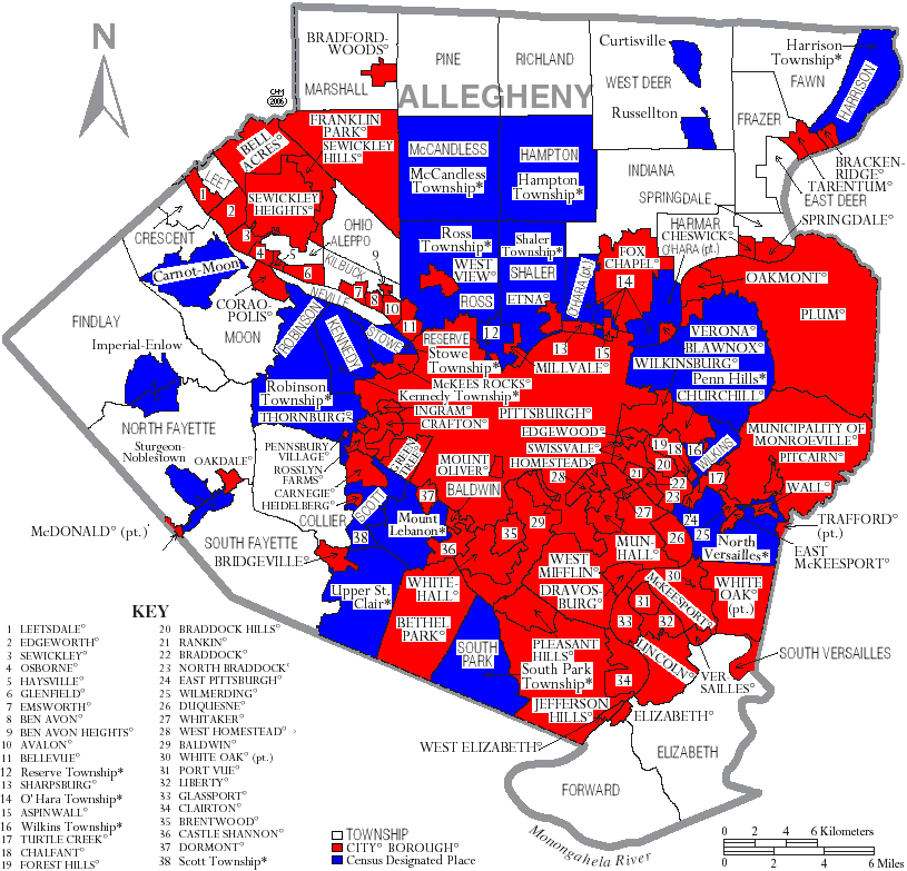
Under Pennsylvania law, there are four types of incorporated municipalities: cities, boroughs, townships, and (in a case) a town. The following municipalities are in Allegheny County:
Cities
- Clairton
- Duquesne
- McKeesport
- Pittsburgh (county seat)
Boroughs
- Aspinwall
- Avalon
- Baldwin
- Bell Acres
- Bellevue
- Ben Avon
- Ben Avon Heights
- Bethel Park
- Blawnox
- Brackenridge
- Braddock
- Braddock Hills
- Bradford Woods
- Brentwood
- Bridgeville
- Carnegie
- Castle Shannon
- Chalfant
- Cheswick
- Churchill
- Coraopolis
- Crafton
- Dormont
- Dravosburg
- East McKeesport
- East Pittsburgh
- Edgewood
- Edgeworth
- Elizabeth
- Emsworth
- Etna
- Forest Hills
- Fox Chapel
- Franklin Park
- Glassport
- Glenfield
- Glen Osborne
- Green Tree
- Haysville
- Heidelberg
- Homestead
- Ingram
- Jefferson Hills
- Leetsdale
- Liberty
- Lincoln
- McDonald (mostly in Washington County)
- McKees Rocks
- Millvale
- Monroeville
- Mount Oliver
- Munhall
- North Braddock
- Oakdale
- Oakmont
- Pennsbury Village
- Pitcairn
- Pleasant Hills
- Plum
- Port Vue
- Rankin
- Rosslyn Farms
- Sewickley
- Sewickley Heights
- Sewickley Hills
- Sharpsburg
- Springdale
- Swissvale
- Tarentum
- Thornburg
- Trafford (mostly in Westmoreland County)
- Turtle Creek
- Verona
- Versailles
- Wall
- West Elizabeth
- West Homestead
- West Mifflin
- West View
- Whitaker
- White Oak
- Whitehall
- Wilkinsburg
- Wilmerding
Townships
- Aleppo
- Baldwin
- Collier
- Crescent
- East Deer
- Elizabeth
- Fawn
- Findlay
- Forward
- Frazer
- Hampton
- Harmar
- Harrison
- Indiana
- Kennedy
- Kilbuck
- Leet
- Marshall
- McCandless
- Moon
- Mt. Lebanon
- Neville
- North Fayette
- North Versailles
- O'Hara
- Ohio
- Penn Hills
- Pine
- Reserve
- Richland
- Robinson
- Ross
- Scott
- Shaler
- South Fayette
- South Park
- South Versailles
- Springdale
- Stowe
- Upper Saint Clair
- West Deer
- Wilkins
Census-designated places
Census-designated places are geographical areas designated by the US Census Bureau for the purposes of compiling demographic data. They are not actual jurisdictions under Pennsylvania law. Other unincorporated communities, such as villages, may be listed here as well.
- Allison Park
- Bairdford
- Bakerstown
- Boston
- Carnot-Moon
- Clinton
- Curtisville
- Enlow
- Gibsonia
- Glenshaw
- Greenock
- Harwick
- Imperial
- Noblestown
- Rennerdale
- Russellton
- Sturgeon
Unincorporated communities
- Acmetonia
- Blackridge
- Blanchard
- Broughton
- Bruceton
- Buena Vista
- Creighton
- Cubbage Hill
- Cuddy
- Dorseyville
- Ewingsville
- Harmarville
- Indianola
- Ingomar
- Karns
- Keown Station
- Kirwan Heights
- Library
- McKnight
- Moon Run
- Mount Vernon
- Natrona
- Natrona Heights
- Nevillewood
- Presto
- Regent Square
- Rural Ridge
- Sheraden
- Warrendale
- Wexford
- Wildwood
Former places
Many political subdivisions of Allegheny County have come and gone through subdivision or annexation through the years. These include:
- Allegheny City – the area that is now the North Shore (or North Side) of the City of Pittsburgh, north of the Allegheny River.
- Allentown Borough – now the neighborhood of Allentown in Pittsburgh.
- Birmingham Borough – what is now Pittsburgh's South Side.
- Brushton Borough
- Carrick Borough – now the neighborhood of Carrick. Formed out of Baldwin Township in 1904, this borough existed until it was annexed by Pittsburgh in 1927. It was named for Carrick-on-Suir, Ireland. Some of the area's manhole covers still bear the Carrick Borough name.
- Chartier Township – existed at the time of the 1860 U.S. Federal Census.
- Collins Township – in what is now the northeast part of the City of Pittsburgh, east of Lawrenceville and north of Penn Avenue.
- Knoxville Borough
- Lawrenceville Borough
- McClure Township – McClure was formed in 1858 from the section of Ross Township adjacent to Allegheny City. In 1867 McClure, along with sections of Reserve Township, was incorporated into Allegheny City. The McClure section of this annexation became Wards 9 (Woods Run Area) and 11 (present-day Brighton Heights) in the City of Pittsburgh.
- Mifflin Township- comprised the modern day communities of Whitaker, West Mifflin, West Homestead, West Elizabeth, Pleasant Hills, Munhall, Lincoln Place, Jefferson Hills, Homestead, Hays, Duquesne, Dravosburg, Clairton and part of Baldwin.
- Patton Township – was in the east-central part of the county, north of North Versailles Township, east of Wilkins and Penn Townships, and south of Plum Township. In the U.S. census for 1860–1880. In 1951 it became incorporated as the borough of Monroeville.
- Northern Liberties Borough – in what is now the Strip District of Pittsburgh. The borough was annexed to Pittsburgh in 1837 as the first addition to the city's original territory.
- Peebles Township – included most of what is now the eastern part of the city of Pittsburgh from the Monongahela River in the south (today's Hazelwood) to the Allegheny River in the north. It was subdivided into Collins and Liberty townships, all of which were incorporated into Pittsburgh in 1868.
- Pitt Township
- St. Clair Township – stretched from the Monongahela River south to the Washington County line. It divided into Lower St. Clair, which eventually became part of the City of Pittsburgh, Dormont, Mount Lebanon, and Upper St. Clair.
- Snowden – now known as South Park Township.
- Sterrett Township
- Temperanceville – what is now Pittsburgh's West End.
- Union Borough – the area surrounding Temperanceville.
- West Liberty Borough – now the neighborhoods of Brookline and Beechview in Pittsburgh.
Population ranking
The population ranking of the following table is based on the 2010 census of Allegheny County.
† county seat
| Rank | City/Town/etc. | Population (2010 Census) | Municipal type | Incorporated |
|---|---|---|---|---|
| 1 | † Pittsburgh | 305,704 | City | 1794 (borough) 1816 (city) |
| 2 | Penn Hills | 42,329 | Municipality | 1851 (Penn Twp.) 1958 (Penn Hills Twp.) 1976 (municipality) |
| 3 | Mt. Lebanon | 33,137 | Municipality | 1912 (township) 1975 (municipality) |
| 4 | Bethel Park | 32,313 | Municipality | 1949 (borough) 1978 (municipality) |
| 5 | Ross | 31,105 | Municipality | 1809 |
| 6 | Monroeville | 28,386 | Municipality | 1951 |
| 7 | Plum | 27,126 | Borough | 1788 (township) 1956 (borough) |
| 8 | Allison Park | 21,552 | CDP | |
| 9 | West Mifflin | 20,313 | Borough | 1942 |
| 10 | Baldwin | 19,767 | Borough | 1950 |
| 11 | McKeesport | 19,731 | City | 1842 (borough) 1891 (city) |
| 12 | Wilkinsburg | 15,930 | Borough | 1871 (Sterrett Twp.) 1887 (borough) |
| 13 | Whitehall | 13,944 | Borough | 1948 |
| 14 | Franklin Park | 13,470 | Borough | 1823 |
| 15 | South Park | 13,416 | Township | 1931 |
| 16 | Munhall | 11,406 | Borough | |
| 17 | Carnot-Moon | 11,372 | CDP | |
| 18 | Jefferson Hills | 10,619 | Borough | |
| 19 | North Versailles | 10,229 | Township | 1869 |
| 20 | Brentwood | 9,643 | Borough | 1916 |
| 21 | Swissvale | 8,983 | Borough | |
| 22 | Glenshaw | 8,981 | CDP | |
| 23 | Dormont | 8,593 | Borough | 1909 |
| 24 | Bellevue | 8,370 | Borough | 1867 |
| 25 | Castle Shannon | 8,316 | Borough | 1919 |
| 26 | Pleasant Hills | 8,268 | Borough | |
| 27 | Carnegie | 7,972 | Borough | 1894 |
| 28 | White Oak | 7,862 | Borough | |
| 29 | Clairton | 6,796 | City | 1903 (borough) 1922 (city) |
| 30 | West View | 6,771 | Borough | |
| 31 | Forest Hills | 6,518 | Borough | 1919 |
| 32 | Oakmont | 6,303 | Borough | 1889 |
| 33 | McKees Rocks | 6,104 | Borough | 1892 |
| 34 | Crafton | 5,951 | Borough | |
| 35 | Coraopolis | 5,677 | Borough | 1886 |
| 36 | Duquesne | 5,565 | City | 1891 (borough) 1918 (city) |
| 37 | Fox Chapel | 5,388 | Borough | |
| 38 | Turtle Creek | 5,349 | Borough | |
| 39 | Bridgeville | 5,148 | Borough | 1901 |
| 40 | North Braddock | 4,857 | Borough | |
| 41 | Avalon | 4,705 | Borough | 1874 |
| 42 | Tarentum | 4,530 | Borough | 1842 |
| 43 | Glassport | 4,483 | Borough | |
| 44 | Green Tree | 4,432 | Borough | 1885 |
| 45 | Sewickley | 3,827 | Borough | |
| 46 | Port Vue | 3,798 | Borough | |
| 47 | Millvale | 3,744 | Borough | |
| 48 | Pitcairn | 3,689 | Borough | |
| 49 | Etna | 3,451 | Borough | |
| 50 | Sharpsburg | 3,446 | Borough | |
| 51 | Springdale | 3,405 | Borough | |
| 52 | Mount Oliver | 3,403 | Borough | |
| 53 | Ingram | 3,330 | Borough | |
| 54 | Brackenridge | 3,260 | Borough | 1901 |
| 55 | Trafford (mostly in Westmoreland County) | 3,174 | Borough | 1904 |
| 56 | Homestead | 3,165 | Borough | |
| 57 | Edgewood | 3,118 | Borough | 1888 |
| 58 | Churchill | 3,011 | Borough | |
| 59 | Aspinwall | 2,801 | Borough | 1892 |
| 60 | Gibsonia | 2,733 | CDP | |
| 61 | Liberty | 2,551 | Borough | |
| 62 | Imperial | 2,541 | CDP | |
| 63 | Verona | 2,474 | Borough | 1871 |
| 64 | Emsworth | 2,449 | Borough | |
| 65 | Greenock | 2,195 | CDP | |
| 66 | Wilmerding | 2,190 | Borough | |
| 67 | Braddock | 2,159 | Borough | 1867 |
| 68 | McDonald (mostly in Washington County) | 2,149 | Borough | 1889 |
| 69 | East McKeesport | 2,126 | Borough | |
| 70 | Rankin | 2,122 | Borough | |
| 71 | West Homestead | 1,929 | Borough | |
| 72 | Braddock Hills | 1,880 | Borough | 1946 |
| 73 | East Pittsburgh | 1,822 | Borough | |
| 74 | Dravosburg | 1,792 | Borough | |
| 75 | Ben Avon | 1,781 | Borough | 1891 |
| 76 | Bakerstown | 1,761 | CDP | |
| 77 | Cheswick | 1,746 | Borough | |
| 78 | Sturgeon | 1,710 | CDP | |
| 79 | Edgeworth | 1,680 | Borough | |
| 80 | Versailles | 1,515 | Borough | |
| 81 | Elizabeth | 1,493 | Borough | |
| 82 | Oakdale | 1,459 | Borough | |
| 83 | Russellton | 1,440 | CDP | |
| 84 | Blawnox | 1,432 | Borough | 1925 |
| 85 | Bell Acres | 1,388 | Borough | 1960 |
| 86 | Whitaker | 1,271 | Borough | |
| 87 | Heidelberg | 1,244 | Borough | |
| 88 | Leetsdale | 1,218 | Borough | |
| 89 | Bradford Woods | 1,171 | Borough | 1915 |
| 90 | Rennerdale | 1,150 | CDP | |
| 91 | Lincoln | 1,072 | Borough | |
| 92 | Curtisville | 1,064 | CDP | |
| 93 | Enlow | 1,013 | CDP | |
| 94 | Harwick | 899 | CDP | |
| 95 | Sewickley Heights | 810 | Borough | |
| 96 | Chalfant | 800 | Borough | |
| 97 | Bairdford | 698 | CDP | |
| 98 | Pennsbury Village | 661 | Borough | |
| 99 | Sewickley Hills | 639 | Borough | |
| 100 | Wall | 580 | Borough | |
| 101 | Noblestown | 575 | CDP | |
| 102 | Glen Osborne | 547 | Borough | |
| 103 | Boston | 545 | CDP | |
| 104 | West Elizabeth | 518 | Borough | |
| 105 | Thornburg | 455 | Borough | |
| 106 | Clinton | 434 | CDP | |
| 107 | Rosslyn Farms | 427 | Borough | |
| 108 | Ben Avon Heights | 371 | Borough | 1913 |
| 109 | Glenfield | 205 | Borough | |
| 110 | Haysville | 70 | Borough |
Notes
References
References
- "Allegheny County, Pennsylvania".
- "PHMC Historical Markers Search". Commonwealth of Pennsylvania.
- "Find a County". National Association of Counties.
- Stewart, George R.. (1967). "Names on the Land: A Historical Account of Place-Naming in the United States". [[Houghton Mifflin]].
- Fiske, John (1902). [https://archive.org/details/newfranceandnew01fiskgoog/page/n334 ''New France and New England''], pp. 290–92. Houghton Mifflin Company.
- "History".
- (April 24, 1930). "Navigation on the Monongahela River". The Daily Republican (Monongahela, Pennsylvania).
- (August 22, 2012). "2010 Census Gazetteer Files". United States Census Bureau.
- "City of Pittsburgh - Allegheny County Quest".
- "Pennsylvania Municipalities Information". Pamunicipalitiesinfo.com.
- Cohan, Jeffrey. (June 20, 2004). "Can 39 towns be turned into one?". Pittsburgh Post-Gazette.
- "Government of Allegheny County, Pennsylvania".
- "Government | Allegheny County".
- "Government | Elected Officials | Allegheny County".
- (January 2, 2024). "Innamorato sworn in as Allegheny County executive". WTAE.
- "Allegheny County Municipality Map".
- "County government overview for Allegheny County, including county executive, county council, row offices, and the role of the Home Rule Charter - League of Women Voters of Greater Pittsburgh".
- (March 22, 2022). "Municipal Authority • Allegheny Township, Westmoreland County, PA".
- (February 7, 2022). "Letter to the editor: Consolidation sorely needed in Allegheny County".
- (1929). "City-County Consolidation in Allegheny County, Pennsylvania". The American Political Science Review.
- "Allegheny County | 404 Error".
- https://www.alleghenycounty.us/Government/Row-Offices/County-Council/Council-Members
- https://triblive.com/local/amy-weise-clements-becomes-acting-allegheny-county-controller/
- Leip, David. "Dave Leip's Atlas of U.S. Presidential Elections".
- (May 19, 2025). "Voter registration statistics by county".
- "Pennsylvania Elections - Summary Results".
- (November 6, 2018). "2018 General Election Official Returns". Pennsylvania Department of State.
- "Members of the House". PA House of Representatives.
- (November 5, 2024). "2024 Senate Election (Official Returns)".
- (2010). "County Membership Report Allegheny County (Pennsylvania)".
- (December 8, 2017). "Social Capital Variables Spreadsheet for 2014".
- "U.S. Decennial Census". United States Census Bureau.
- "Historical Census Browser". University of Virginia Library.
- (March 27, 1995). "Population of Counties by Decennial Census: 1900 to 1990". United States Census Bureau.
- (April 2, 2001). "Census 2000 PHC-T-4. Ranking Tables for Counties: 1990 and 2000". United States Census Bureau.
- "State & County QuickFacts". United States Census Bureau.
- "County Population Totals and Components of Change: 2020-2023".
- (2021). "2020 Decennial Census Demographic Profile (DP1)".
- (2021). "2020 Decennial Census Redistricting Data (Public Law 94-171)".
- (2023). "2020 Decennial Census Demographic and Housing Characteristics (DHC)".
- "P004: Hispanic or Latino, and Not Hispanic or Latino by Race – 2000: DEC Summary File 1 – Allegheny County, Pennsylvania". [[United States Census Bureau]].
- "P2 Hispanic or Latino, and Not Hispanic or Latino by Race – 2010: DEC Redistricting Data (PL 94-171) - Allegheny County, Pennsylvania".
- "P2 Hispanic or Latino, and Not Hispanic or Latino by Race – 2020: DEC Redistricting Data (PL 94-171) - Allegheny County, Pennsylvania".
- "U.S. Census website". [[United States Census Bureau]].
- (July 3, 2012). "Automatic defense cuts would affect some contractors in Pittsburgh region". Pittsburgh Post-Gazette.
- Geography Division. (January 14, 2021). "2020 census - school district reference map: Allegheny County, PA". [[U.S. Census Bureau]].
- Panizzi, Tawnya. (April 8, 2021). "Allegheny Land Trust finalizes purchase of Girty's Woods in Reserve, shielding 155-acre forest from development".
- Phox, Jason. (February 16, 2023). "Allegheny Land Trust acquires more than 120 acres as protected green space".
- Barron, Joanne. (November 2012). "New director has big plans for Allegheny Land Trust". Pittsburgh Trib Live.
- Waltz, Amanda. (October 19, 2020). "Allegheny Land Trust awarded grant to transform former country club into public green space".
- (November 26, 2019). "$500,000 grant announced to help Allegheny Land Trust purchase former Churchill Valley Country Club".
- "Donation to add acreage to North Park in Hampton".
- Esposito, Laura. (April 3, 2025). "Study: County Parks a Boon to Area". [[Pittsburgh Post-Gazette]].
- Schmitz, Jon. (July 23, 2012). "Kirwan Heights loses Interstate 79 designation". [[Pittsburgh Post-Gazette]].
- "Profile: Cuddy, Pennsylvania". Mapquest.
- "Profile: Sheraden, Pennsylvania". U.S. Geological Survey.
- [https://www.ancestry.com/interactive/7667/4282818_00072?pid=3065602 1860 United States Federal Census - Chartier Township], accessed April 2018 via ancestry.com paid subscription site.
- "Mifflin Township Historical Society Attraction Details". ExplorePAhistory.com.
- Center for New Media and Promotions(C2PO). "2010 Census". United States Census Bureau.
This article was imported from Wikipedia and is available under the Creative Commons Attribution-ShareAlike 4.0 License. Content has been adapted to SurfDoc format. Original contributors can be found on the article history page.
Ask Mako anything about Allegheny County, Pennsylvania — get instant answers, deeper analysis, and related topics.
Research with MakoFree with your Surf account
Create a free account to save articles, ask Mako questions, and organize your research.
Sign up freeThis content may have been generated or modified by AI. CloudSurf Software LLC is not responsible for the accuracy, completeness, or reliability of AI-generated content. Always verify important information from primary sources.
Report