From Surf Wiki (app.surf) — the open knowledge base
Alaska North Slope
Northern region of Alaska, United States
Northern region of Alaska, United States
The Alaska North Slope is the region of the U.S. state of Alaska located on the northern slope of the Brooks Range along the coast of two marginal seas of the Arctic Ocean, the Chukchi Sea being on the western side of Point Barrow, and the Beaufort Sea on the eastern. With the exception of the highway connecting Fairbanks to Prudhoe Bay, the region is disconnected from the rest of the Alaskan road system and relies mostly on waterways and small airports for transportation due to the Brooks Range secluding the region from the rest of the state.
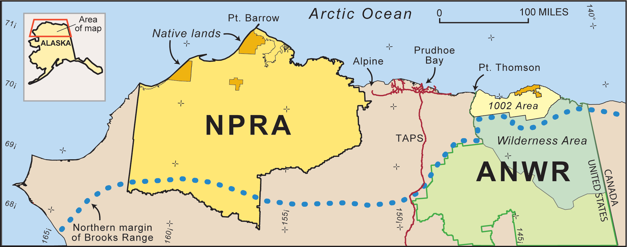
The entire Arctic coastal plain of Alaska with its Arctic coastal tundra has tremendous ecological importance with the densest concentration of birds in the Arctic, along with housing substantial amounts of large mammals such as whales, walrus, seals, caribou, and moose. The region includes the Arctic National Wildlife Refuge (ANWR) as well as the National Petroleum Reserve–Alaska (NPRA).
Topography

Within the North Slope, only a surface "active layer" of the tundra thaws each season; most of the soil is permanently frozen year-round. On top of this permafrost, water flows out to sea via shallow, braided streams or settles into pools and ponds. Along the bottom of the Landsat 7 image on the right, the rugged terrain of the Brooks Range mountains is snow-covered in places (blue areas) and exposed (pink areas) in others.
Much of the region is located politically in North Slope Borough, and geographically in the Alaska North Slope basin.
On August 12, 2018, a 6.4 magnitude earthquake hit the region, the most powerful recorded for the Alaskan North Slope.
Ecology
The region includes the Arctic National Wildlife Refuge. The entire coastal plain of Alaska has tremendous ecological importance, with the densest concentration of birds in the Arctic.
Petroleum resources


Under the North Slope is an ancient seabed, which now contains large amounts of petroleum. Within the North Slope, there is a geological feature called the Barrow Arch — a belt of the kind of rock known to be able to serve as a trap for oil. It runs from the city of Utqiaġvik to a point just west of the Arctic National Wildlife Refuge.
Ira Harkey quotes Noel Wien as stating that in the 1920s, "To keep warm and to cook with, the Eskimo was burning hunks of dark stuff he just picked up on the ground all around his tent. This was oil from seepage under the tundra. The Eskimos had always known about the oil, long before there was any drilling for it."
The North Slope region includes the National Petroleum Reserve–Alaska (NPRA), which was established by President Warren G. Harding in 1923 as an oil supply for the US Navy, though the presence of oil in the region had been known by American whalers for some time. It constituted the bulk of Alaska's known petroleum until the Prudhoe Bay Oil Field was discovered (outside the NPRA) in 1968, followed by the Kuparuk River oil field in 1969. The petroleum extracted from the region is transferred south by means of the Trans-Alaska Pipeline System to Valdez on the Pacific Ocean.
In 2005 the USGS estimated that the Arctic Alaska Petroleum Province, encompassing all the lands and adjacent Continental Shelf areas north of the Brooks Range-Herald arch (see map) held more than 50 billion bbl of oil and natural-gas liquids and 227 trillion cubic feet of gas.
The source rock for the Prudhoe Bay Oil Field and neighboring reserves is also a potential source for unconventional tight oil and shale gas – possibly containing "up to 2 billion barrels of technically recoverable oil and up to 80 trillion cubic feet of natural gas, according to a 2012 U.S. Geological Survey report."
Alaska North Slope (ANS) is a more expensive waterborne crude oil. Since 1987, Alaska North Slope (ANS) crude production has been in decline.
As of 2020, the U.S. Geological Survey estimated 3.6 billion barrels of oil and 8.9 trillion cubic feet of natural gas in Mississippian through Paleogene strata in the central North Slope of Alaska, which are undiscovered and technically recoverable.
References
References
- Alaska Department of Commerce, Community, and Economic Development, Northern Opportunity Alaska's Economic Development Strategy, 2016, at 84 (Alaska 2016). Accessed June 1, 2023. https://www.commerce.alaska.gov/web/portals/0/pub/CEDS/2017-2022-Statewide-CEDS.pdf.
- "M 6.4 - 89km SW of Kaktovik, Alaska". U.S. Geological Survey.
- (2019-09-10). "Alaska’s petroleum reserve is open for drilling. Will the birds survive?".
- Houseknecht, David W.. "Studies by the U.S. Geological Survey in Alaska, 2005".
- (1991). "Pioneer Bush Pilot". Bantam Books.
- Canby, Peter. (November 17, 2005). "The Specter Haunting Alaska". New York Review of Books.
- Margaret Kriz Hobson. (April 3, 2013). "SHALE OIL: Geologist's Alaska gamble could turn into America's next big shale play". [[EnergyWire]], E & E Publishing.
- (5 June 2013). "North American production boom pushes crude blending". Oil & Gas Journal.
- Fielden, Sandy. (February 1, 2013). "After the Oil Rush – ANS Decline and the West Coast Crude Market". RBN Energy.
- Houseknecht, David W.. (2020). "Assessment of undiscovered oil and gas resources in the Central North Slope of Alaska, 2020".
This article was imported from Wikipedia and is available under the Creative Commons Attribution-ShareAlike 4.0 License. Content has been adapted to SurfDoc format. Original contributors can be found on the article history page.
Ask Mako anything about Alaska North Slope — get instant answers, deeper analysis, and related topics.
Research with MakoFree with your Surf account
Create a free account to save articles, ask Mako questions, and organize your research.
Sign up freeThis content may have been generated or modified by AI. CloudSurf Software LLC is not responsible for the accuracy, completeness, or reliability of AI-generated content. Always verify important information from primary sources.
Report