From Surf Wiki (app.surf) — the open knowledge base
Adforton
Village in Herefordshire, England
..PNG)
Village in Herefordshire, England
| Field | Value |
|---|---|
| country | England |
| coordinates | |
| official_name | Adforton |
| static_image_name | St Andrews Church..png |
| static_image_caption | St Andrews Church |
| population_ref | 2011 census |
| civil_parish | Adforton |
| lieutenancy_england | Herefordshire |
| unitary_england | Herefordshire |
| region | West Midlands |
| post_town | Craven Arms |
| postcode_district | SY7 |
| postcode_area | SY |
| dial_code | 01568/01547 |
| os_grid_reference | SO40417114 |
| constituency_westminster | North Herefordshire |
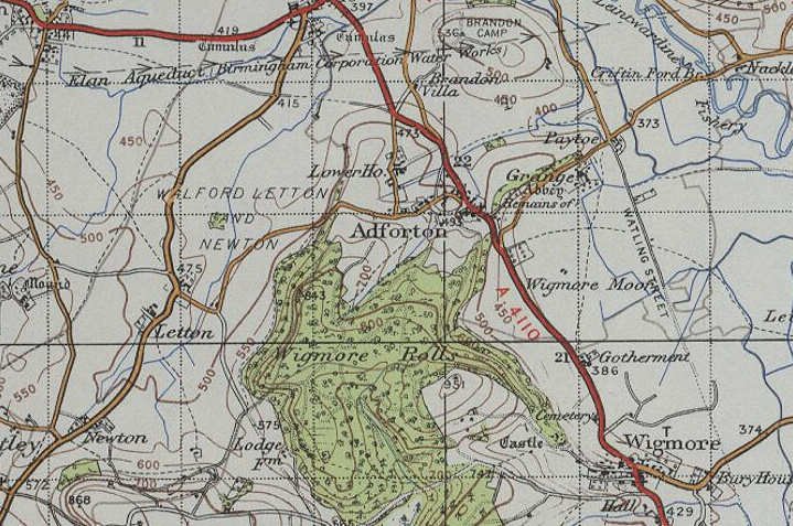
Adforton is a small village and a civil parish in north Herefordshire, England. It is on the A4110 main road approximately 22 mi north of Hereford and of Wigmore, and is close to the Wales border.
History
The name Adforton means 'settlement of Ad's fort'.
John Marius Wilson's Imperial Gazetteer of England and Wales describes Adforton as "a township with Stanway, Paytoe, and Grange, in the parish of Leintwardine, in Hereford 2 miles north west of Wigmore with a population of 250 people and 57 houses within the area."
Demography


Between 1881 and 2001 the population fluctuated, but reduced from 204 to 118. Census data shows a peak population of 215 in 1901. Since 2001, with its lowest point of 118 residents, the population rose, and by 2011 was 128.
The census data for 1881 shows that agricultural work was the dominant occupation among males, with 32 men working on farms and with animals; other occupation areas for men included the professions, furniture design and lodging. Data for females shows that most occupations (29) were unspecified and another six were unknown.
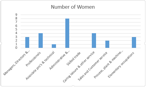
According to the 2011 census, occupations in skilled trades was the most widespread for men, while six men were variously employed as managers, directors, professionals and senior officials; occupations with lowest counts were in sales and customer service and administrative and secretarial occupations. Eight women were employed in administrative and secretarial services, with the lowest count was for professions.

Church
St Andrew's Church was designed and built in 1875 by the architect John Pollard Seddon. Until St Andrew's was built there was only a 1863-built Primitive Methodist chapel. The church doubles as a community hall.
North of the village are the remains of Wigmore Abbey and fragments of its monastic grange. Established in 1179, in the Middle Ages the abbey was the largest, and among the most prosperous, in Herefordshire. The grange comprises a range of buildings which have now been converted into a house.
References
References
- (1870). "Gazetteer of England and Wales". A. Fullerton & Co..
- "Adforton population data 1881–1961".
- "1881 occupational data for Adforton.".
- "Occupation data for Adforton- Females, 2011 census.".
- "Occupation data for Adforton: Males, 2011 census.".
- {{National Heritage List for England
- "Adforton History".
- "Find us – Adforton St Andrew – A Church Near You".
- {{NHLE
- {{NHLE
This article was imported from Wikipedia and is available under the Creative Commons Attribution-ShareAlike 4.0 License. Content has been adapted to SurfDoc format. Original contributors can be found on the article history page.
Ask Mako anything about Adforton — get instant answers, deeper analysis, and related topics.
Research with MakoFree with your Surf account
Create a free account to save articles, ask Mako questions, and organize your research.
Sign up freeThis content may have been generated or modified by AI. CloudSurf Software LLC is not responsible for the accuracy, completeness, or reliability of AI-generated content. Always verify important information from primary sources.
Report