From Surf Wiki (app.surf) — the open knowledge base
Abyssal plain
Flat area on the deep ocean floor

Flat area on the deep ocean floor

An abyssal plain is an underwater plain on the deep ocean floor, usually found at depths between 3000 and. Lying generally between the foot of a continental rise and a mid-ocean ridge, abyssal plains cover more than 50% of the Earth's surface.{{Cite journal |access-date=18 June 2010 |archive-date=20 July 2011 |archive-url=https://web.archive.org/web/20110720075942/http://cmbc.ucsd.edu/Students/Current_Students/SIO277/Smith%20et%20al.%20TREE%202008.pdf |url-status=dead |access-date = 18 June 2010 |url-status = dead |archive-url = https://web.archive.org/web/20101224060317/http://sp.lyellcollection.org/cgi/issue_pdf/frontmatter_pdf/31/1.pdf |archive-date = 24 December 2010
The creation of the abyssal plain is the result of the spreading of the seafloor (plate tectonics) and the melting of the lower oceanic crust. Magma rises from above the asthenosphere (a layer of the upper mantle), and as this basaltic material reaches the surface at mid-ocean ridges, it forms new oceanic crust, which is constantly pulled sideways by spreading of the seafloor. Abyssal plains result from the blanketing of an originally uneven surface of oceanic crust by fine-grained sediments, mainly clay and silt. Much of this sediment is deposited by turbidity currents that have been channelled from the continental margins along submarine canyons into deeper water. The rest is composed chiefly of pelagic sediments. Metallic nodules are common in some areas of the plains, with varying concentrations of metals, including manganese, iron, nickel, cobalt, and copper. There are also amounts of carbon, nitrogen, phosphorus and silicon, due to material that comes down and decomposes.
Owing in part to their vast size, abyssal plains are believed to be major reservoirs of biodiversity. They also exert significant influence upon ocean carbon cycling, dissolution of calcium carbonate, and atmospheric CO2 concentrations over time scales of a hundred to a thousand years. The structure of abyssal ecosystems is strongly influenced by the rate of flux of food to the seafloor and the composition of the material that settles. Factors such as climate change, fishing practices, and ocean fertilization have a substantial effect on patterns of primary production in the euphotic zone. Animals absorb dissolved oxygen from the oxygen-poor waters. Much dissolved oxygen in abyssal plains came from polar regions that had melted long ago. Due to scarcity of oxygen, abyssal plains are inhospitable for organisms that would flourish in the oxygen-enriched waters above. Deep sea coral reefs are mainly found in depths of 3,000 meters and deeper in the abyssal and hadal zones.
Abyssal plains were not recognized as distinct physiographic features of the sea floor until the late 1940s and, until recently, none had been studied on a systematic basis. They are poorly preserved in the sedimentary record, because they tend to be consumed by the subduction process. Due to darkness and a water pressure that can reach about 750 times atmospheric pressure (76 megapascal), abyssal plains are not well explored.
Oceanic zones
Main article: Oceanic zone

The ocean can be conceptualized as zones, depending on depth, and presence or absence of sunlight. Nearly all life forms in the ocean depend on the photosynthetic activities of phytoplankton and other marine plants to convert carbon dioxide into organic carbon, which is the basic building block of organic matter. Photosynthesis in turn requires energy from sunlight to drive the chemical reactions that produce organic carbon.{{Cite journal
The stratum of the water column nearest the surface of the ocean (sea level) is referred to as the photic zone. The photic zone can be subdivided into two different vertical regions. The uppermost portion of the photic zone, where there is adequate light to support photosynthesis by phytoplankton and plants, is referred to as the euphotic zone (also referred to as the epipelagic zone, or surface zone). The lower portion of the photic zone, where the light intensity is insufficient for photosynthesis, is called the dysphotic zone (dysphotic means "poorly lit" in Greek).{{cite encyclopedia |access-date=18 June 2010}} The dysphotic zone is also referred to as the mesopelagic zone, or the twilight zone.{{Cite web |access-date=18 June 2010}} Its lowermost boundary is at a thermocline of 12 C, which, in the tropics generally lies between 200 and 1,000 metres.{{Cite journal
The euphotic zone is somewhat arbitrarily defined as extending from the surface to the depth where the light intensity is approximately 0.1–1% of surface sunlight irradiance, depending on season, latitude and degree of water turbidity. In the clearest ocean water, the euphotic zone may extend to a depth of about 150 metres, or rarely, up to 200 metres. Dissolved substances and solid particles absorb and scatter light, and in coastal regions the high concentration of these substances causes light to be attenuated rapidly with depth. In such areas the euphotic zone may be only a few tens of metres deep or less. The dysphotic zone, where light intensity is considerably less than 1% of surface irradiance, extends from the base of the euphotic zone to about 1,000 metres. Extending from the bottom of the photic zone down to the seabed is the aphotic zone, a region of perpetual darkness.
Since the average depth of the ocean is about 4,300 metres,{{Cite web |author-link1=National Oceanic and Atmospheric Administration|date=2 December 2008 |access-date=19 June 2010| archive-url= https://web.archive.org/web/20100623180747/http://oceanservice.noaa.gov/facts/oceandepth.html| archive-date= 23 June 2010 | url-status= live}} the photic zone represents only a tiny fraction of the ocean's total volume. However, due to its capacity for photosynthesis, the photic zone has the greatest biodiversity and biomass of all oceanic zones. Nearly all primary production in the ocean occurs here. Life forms which inhabit the aphotic zone are often capable of movement upwards through the water column into the photic zone for feeding. Otherwise, they must rely on material sinking from above, or find another source of energy and nutrition, such as occurs in chemosynthetic archaea found near hydrothermal vents and cold seeps.
The aphotic zone can be subdivided into three different vertical regions, based on depth and temperature. First is the bathyal zone, extending from a depth of 1,000 metres down to 3,000 metres, with water temperature decreasing from 12 °C to 4 °C as depth increases.{{cite news |author-link=Rebecca Morelle |access-date=18 June 2010| archive-url= https://web.archive.org/web/20100730022055/http://news.bbc.co.uk/2/hi/science/nature/7655358.stm| archive-date= 30 July 2010 | url-status= live}} Next is the abyssal zone, extending from a depth of 3,000 metres down to 6,000 metres. The final zone includes the deep oceanic trenches, and is known as the hadal zone. This, the deepest oceanic zone, extends from a depth of 6,000 metres down to approximately 11,034 meters, at the very bottom of the Mariana Trench, the deepest point on planet Earth. Abyssal plains are typically in the abyssal zone, at depths from 3,000 to 6,000 metres.
The table below illustrates the classification of oceanic zones:
| Zone | Subzone (common name) | Depth of zone | Water temperature | Comments |
|---|---|---|---|---|
| photic | euphotic (epipelagic zone) | 0–200 metres | highly variable | |
| disphotic (mesopelagic zone, or twilight zone) | 200–1,000 metres | 4 °C – highly variable | ||
| aphotic | bathyal | 1,000–3,000 metres | 4 - | |
| abyssal | 3,000–6,000 metres | 0 - | water temperature may reach as high as 464 °C near hydrothermal vents{{Cite journal | author=Haase, K. M. |
| hadal | below 6,000 metres{{Cite journal | author1=Alan J. Jamieson | author2=Toyonobu Fujii | author3=Daniel J. Mayor |
Formation
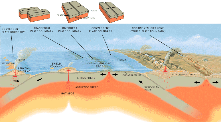

Oceanic crust, which forms the bedrock of abyssal plains, is continuously being created at mid-ocean ridges (a type of divergent boundary) by a process known as decompression melting. Plume-related decompression melting of solid mantle is responsible for creating ocean islands like the Hawaiian islands, as well as the ocean crust at mid-ocean ridges. This phenomenon is also the most common explanation for flood basalts and oceanic plateaus (two types of large igneous provinces). Decompression melting occurs when the upper mantle is partially melted into magma as it moves upwards under mid-ocean ridges.{{Cite journal
The lithosphere, which rides atop the asthenosphere, is divided into a number of tectonic plates that are continuously being created and consumed at their opposite plate boundaries. Oceanic crust and tectonic plates are formed and move apart at mid-ocean ridges. Abyssal hills are formed by stretching of the oceanic lithosphere.{{Cite journal The subduction process consumes older oceanic lithosphere, so oceanic crust is seldom more than 200 million years old.{{Cite web |access-date=24 June 2010}} The overall process of repeated cycles of creation and destruction of oceanic crust is known as the Supercontinent cycle, first proposed by Canadian geophysicist and geologist John Tuzo Wilson.
New oceanic crust, closest to the mid-oceanic ridges, is mostly basalt at shallow levels and has a rugged topography. The roughness of this topography is a function of the rate at which the mid-ocean ridge is spreading (the spreading rate).{{Cite journal |access-date=23 June 2010
The flat appearance of mature abyssal plains results from the blanketing of this originally uneven surface of oceanic crust by fine-grained sediments, mainly clay and silt. Much of this sediment is deposited from turbidity currents that have been channeled from the continental margins along submarine canyons down into deeper water. The remainder of the sediment comprises chiefly dust (clay particles) blown out to sea from land, and the remains of small marine plants and animals which sink from the upper layer of the ocean, known as pelagic sediments. The total sediment deposition rate in remote areas is estimated at two to three centimeters per thousand years.{{Cite journal |doi-access=free |chapter-url=http://www.deepseadrilling.org/12/volume/dsdp12_11.pdf |access-date=24 June 2010|display-editors=etal}} Sediment-covered abyssal plains are less common in the Pacific Ocean than in other major ocean basins because sediments from turbidity currents are trapped in oceanic trenches that border the Pacific Ocean.{{Cite journal
Abyssal plains are typically covered by deep sea, but during parts of the Messinian salinity crisis much of the Mediterranean Sea's abyssal plain was exposed to air as an empty deep hot dry salt-floored sink.{{cite journal |access-date=1 October 2010 |display-authors=etal}}
Discovery

The landmark scientific expedition (December 1872 – May 1876) of the British Royal Navy survey ship HMS Challenger yielded a tremendous amount of bathymetric data, much of which has been confirmed by subsequent researchers. Bathymetric data obtained during the course of the Challenger expedition enabled scientists to draw maps,{{Cite book |access-date=26 June 2010}} which provided a rough outline of certain major submarine terrain features, such as the edge of the continental shelves and the Mid-Atlantic Ridge. This discontinuous set of data points was obtained by the simple technique of taking soundings by lowering long lines from the ship to the seabed.{{Cite book |access-date = 26 June 2010 |archive-url = https://web.archive.org/web/20110724205544/http://www.19thcenturyscience.org/HMSC/HMSC-Reports/1891-DeepSeaDeposits/htm/doc.html |archive-date = 24 July 2011 |url-status = dead
The Challenger expedition was followed by the 1879–1881 expedition of the Jeannette, led by United States Navy Lieutenant George Washington DeLong. The team sailed across the Chukchi Sea and recorded meteorological and astronomical data in addition to taking soundings of the seabed. The ship became trapped in the ice pack near Wrangel Island in September 1879, and was ultimately crushed and sunk in June 1881.{{Cite book |orig-year=First published in 1968 |chapter-url=http://www.history.navy.mil/danfs/j2/jeannette.htm |access-date=26 June 2010 |author-link=Naval History & Heritage Command |archive-url=https://web.archive.org/web/20100708095936/http://www.history.navy.mil/danfs/j2/jeannette.htm |archive-date=8 July 2010 |url-status=dead
The Jeannette expedition was followed by the 1893–1896 Arctic expedition of Norwegian explorer Fridtjof Nansen aboard the Fram, which proved that the Arctic Ocean was a deep oceanic basin, uninterrupted by any significant land masses north of the Eurasian continent.{{Cite web |access-date=26 June 2010 |archive-url=https://web.archive.org/web/20090416163515/http://academic.emporia.edu/aberjame/histgeol/nansen/nansen.htm |archive-date=16 April 2009 |url-status=dead |access-date=26 June 2010}}
Beginning in 1916, Canadian physicist Robert William Boyle and other scientists of the Anti-Submarine Detection Investigation Committee (ASDIC) undertook research which ultimately led to the development of sonar technology. Acoustic sounding equipment was developed which could be operated much more rapidly than the sounding lines, thus enabling the German Meteor expedition aboard the German research vessel Meteor (1925–27) to take frequent soundings on east-west Atlantic transects. Maps produced from these techniques show the major Atlantic basins, but the depth precision of these early instruments was not sufficient to reveal the flat featureless abyssal plains.{{Cite journal |access-date=26 June 2010}}
As technology improved, measurement of depth, latitude and longitude became more precise and it became possible to collect more or less continuous sets of data points. This allowed researchers to draw accurate and detailed maps of large areas of the ocean floor. Use of a continuously recording fathometer enabled Tolstoy & Ewing in the summer of 1947 to identify and describe the first abyssal plain. This plain, south of Newfoundland, is now known as the Sohm Abyssal Plain.{{Cite journal
The Challenger Deep is the deepest surveyed point of all of Earth's oceans; it is at the south end of the Mariana Trench near the Mariana Islands group. The depression is named after HMS Challenger, whose researchers made the first recordings of its depth on 23 March 1875 at station 225. The reported depth was 4,475 fathoms (8184 meters) based on two separate soundings. On 1 June 2009, sonar mapping of the Challenger Deep by the Simrad EM120 multibeam sonar bathymetry system aboard the R/V Kilo Moana indicated a maximum depth of 10971 meters (6.82 miles). The sonar system uses phase and amplitude bottom detection, with an accuracy of better than 0.2% of water depth (this is an error of about 22 meters at this depth).{{Cite web |access-date=26 June 2010 |url-status=dead |archive-url=https://archive.today/20120524194643/http://www.soest.hawaii.edu/UMC/Reports/Archives/KMreportJuneJuly2009.html |archive-date=24 May 2012 |access-date=26 June 2010 |url-status=dead |archive-url=https://web.archive.org/web/20100613143513/http://www.soest.hawaii.edu/UMC/KM/scienceequipment.htm |archive-date=13 June 2010
Terrain features
Hydrothermal vents

Main article: Hydrothermal vent
A rare but important terrain feature found in the bathyal, abyssal and hadal zones is the hydrothermal vent. In contrast to the approximately 2 °C ambient water temperature at these depths, water emerges from these vents at temperatures ranging from 60 °C up to as high as 464 °C. Due to the high barometric pressure at these depths, water may exist in either its liquid form or as a supercritical fluid at such temperatures.
At a barometric pressure of 218 atmospheres, the critical point of water is 375 °C. At a depth of 3,000 meters, the barometric pressure of sea water is more than 300 atmospheres (as salt water is denser than fresh water). At this depth and pressure, seawater becomes supercritical at a temperature of 407 °C (see image). However the increase in salinity at this depth pushes the water closer to its critical point. Thus, water emerging from the hottest parts of some hydrothermal vents, black smokers and submarine volcanoes can be a supercritical fluid, possessing physical properties between those of a gas and those of a liquid.
Sister Peak (Comfortless Cove Hydrothermal Field, , elevation −2996 m), Shrimp Farm and Mephisto (Red Lion Hydrothermal Field, , elevation −3047 m), are three hydrothermal vents of the black smoker category, on the Mid-Atlantic Ridge near Ascension Island. They are presumed to have been active since an earthquake shook the region in 2002. These vents have been observed to vent phase-separated, vapor-type fluids. In 2008, sustained exit temperatures of up to 407 °C were recorded at one of these vents, with a peak recorded temperature of up to 464 °C. These thermodynamic conditions exceed the critical point of seawater, and are the highest temperatures recorded to date from the seafloor. This is the first reported evidence for direct magmatic-hydrothermal interaction on a slow-spreading mid-ocean ridge. The initial stages of a vent chimney begin with the deposition of the mineral anhydrite. Sulfides of copper, iron, and zinc then precipitate in the chimney gaps, making it less porous over the course of time. Vent growths on the order of 30 cm (1 ft) per day have been recorded. [11] An April 2007 exploration of the deep-sea vents off the coast of Fiji found those vents to be a significant source of dissolved iron (see iron cycle).
Hydrothermal vents in the deep ocean typically form along the mid-ocean ridges, such as the East Pacific Rise and the Mid-Atlantic Ridge. These are locations where two tectonic plates are diverging and new crust is being formed.
Cold seeps

Main article: Cold seep
Another unusual feature found in the abyssal and hadal zones is the cold seep, sometimes called a cold vent. This is an area of the seabed where seepage of hydrogen sulfide, methane and other hydrocarbon-rich fluid occurs, often in the form of a deep-sea brine pool. The first cold seeps were discovered in 1983, at a depth of 3200 meters in the Gulf of Mexico.{{Cite journal |access-date=19 June 2010}}
Biodiversity
Though the plains were once assumed to be vast, desert-like habitats, research over the past decade or so shows that they teem with a wide variety of microbial life.{{Cite journal |access-date = 26 June 2010 |archive-url = https://web.archive.org/web/20100527223751/http://explore.noaa.gov/abstract-and-bio-census-of-the-diversity-of-abyssal-marine-life-dr-craig-smith/ |archive-date = 27 May 2010 |url-status = dead
Abyssobrotula galatheae, a species of cusk eel in the family Ophidiidae, is among the deepest-living species of fish. In 1970, one specimen was trawled from a depth of 8370 meters in the Puerto Rico Trench.{{Cite book |access-date=26 June 2010| archive-url= https://web.archive.org/web/20100628211038/http://www.extremescience.com/zoom/index.php/life-in-the-deep-ocean/44-deepest-fish| archive-date= 28 June 2010 | url-status= live}} Other fish of the abyssal zone include the fishes of the family Ipnopidae, which includes the abyssal spiderfish (Bathypterois longipes), tripodfish (Bathypterois grallator), feeler fish (Bathypterois longifilis), and the black lizardfish (Bathysauropsis gracilis). Some members of this family have been recorded from depths of more than 6000 meters.{{Cite web |access-date=26 June 2010}}
CeDAMar scientists have demonstrated that some abyssal and hadal species have a cosmopolitan distribution. One example of this would be protozoan foraminiferans,{{Cite journal
Eleven of the 31 described species of Monoplacophora (a class of mollusks) live below 2000 meters. Of these 11 species, two live exclusively in the hadal zone.{{Cite book |chapter-url=http://www.mapress.com/zootaxa/2008/f/zt01866p222.pdf |access-date=26 June 2010}} The greatest number of monoplacophorans are from the eastern Pacific Ocean along the oceanic trenches. However, no abyssal monoplacophorans have yet been found in the Western Pacific and only one abyssal species has been identified in the Indian Ocean. Of the 922 known species of chitons (from the Polyplacophora class of mollusks), 22 species (2.4%) are reported to live below 2000 meters and two of them are restricted to the abyssal plain. Although genetic studies are lacking, at least six of these species are thought to be eurybathic (capable of living in a wide range of depths), having been reported as occurring from the sublittoral to abyssal depths. A large number of the polyplacophorans from great depths are herbivorous or xylophagous, which could explain the difference between the distribution of monoplacophorans and polyplacophorans in the world's oceans.
Peracarid crustaceans, including isopods, are known to form a significant part of the macrobenthic community that is responsible for scavenging on large food falls onto the sea floor.{{Cite journal |access-date=26 June 2010 |archive-url=https://web.archive.org/web/20090120094611/http://crustacea.net/crustace/www/asellota.htm |archive-date=20 January 2009 |url-status=dead
In 2005, the Japan Agency for Marine-Earth Science and Technology (JAMSTEC) remotely operated vehicle, KAIKO, collected sediment core from the Challenger Deep. 432 living specimens of soft-walled foraminifera were identified in the sediment samples.{{Cite journal |archive-url=https://web.archive.org/web/20050205041944/http://news.nationalgeographic.com/news/2005/02/0203_050203_deepest.html |url-status=dead |archive-date=5 February 2005 |access-date=26 June 2010}} Foraminifera are single-celled protists that construct shells. There are an estimated 4,000 species of living foraminifera. Out of the 432 organisms collected, the overwhelming majority of the sample consisted of simple, soft-shelled foraminifera, with others representing species of the complex, multi-chambered genera Leptohalysis and Reophax. Overall, 85% of the specimens consisted of soft-shelled allogromiids. This is unusual compared to samples of sediment-dwelling organisms from other deep-sea environments, where the percentage of organic-walled foraminifera ranges from 5% to 20% of the total. Small organisms with hard calciferous shells have trouble growing at extreme depths because the water at that depth is severely lacking in calcium carbonate.{{Cite journal
While similar lifeforms have been known to exist in shallower oceanic trenches (7,000 m) and on the abyssal plain, the lifeforms discovered in the Challenger Deep may represent independent taxa from those shallower ecosystems. This preponderance of soft-shelled organisms at the Challenger Deep may be a result of selection pressure. Millions of years ago, the Challenger Deep was shallower than it is now. Over the past six to nine million years, as the Challenger Deep grew to its present depth, many of the species present in the sediment of that ancient biosphere were unable to adapt to the increasing water pressure and changing environment. Those species that were able to adapt may have been the ancestors of the organisms currently endemic to the Challenger Deep.
Polychaetes occur throughout the Earth's oceans at all depths, from forms that live as plankton near the surface, to the deepest oceanic trenches. The robot ocean probe Nereus observed a 2–3 cm specimen (still unclassified) of polychaete at the bottom of the Challenger Deep on 31 May 2009.{{Cite web |access-date=26 June 2010}}{{Cite journal |access-date=26 June 2010 | archive-url= https://web.archive.org/web/20100601172511/http://www.whoi.edu/oceanus/viewArticle.do?id=57606| archive-date= 1 June 2010 | url-status= live}}{{Cite web |access-date=26 June 2010}} There are more than 10,000 described species of polychaetes; they can be found in nearly every marine environment. Some species live in the coldest ocean temperatures of the hadal zone, while others can be found in the extremely hot waters adjacent to hydrothermal vents.
Within the abyssal and hadal zones, the areas around submarine hydrothermal vents and cold seeps have by far the greatest biomass and biodiversity per unit area. Fueled by the chemicals dissolved in the vent fluids, these areas are often home to large and diverse communities of thermophilic, halophilic and other extremophilic prokaryotic microorganisms (such as those of the sulfide-oxidizing genus Beggiatoa), often arranged in large bacterial mats near cold seeps. In these locations, chemosynthetic archaea and bacteria typically form the base of the food chain. Although the process of chemosynthesis is entirely microbial, these chemosynthetic microorganisms often support vast ecosystems consisting of complex multicellular organisms through symbiosis.{{Cite book |author-link1=Minerals Management Service|title=Gulf of Mexico OCS Oil and Gas Lease Sales: 2007–2012. Western Planning Area Sales 204, 207, 210, 215, and 218. Central Planning Area Sales 205, 206, 208, 213, 216, and 222. Draft Environmental Impact Statement. Volume I |chapter-url=http://www.gomr.mms.gov/PDFs/2006/2006-062-Vol1.pdf |access-date=20 June 2010 |url-status=dead |archive-url=https://web.archive.org/web/20090326005638/http://www.gomr.mms.gov/PDFs/2006/2006-062-Vol1.pdf |archive-date=26 March 2009
Probably the most important ecological characteristic of abyssal ecosystems is energy limitation. Abyssal seafloor communities are considered to be food limited because benthic production depends on the input of detrital organic material produced in the euphotic zone, thousands of meters above. Most of the organic flux arrives as an attenuated rain of small particles (typically, only 0.5–2% of net primary production in the euphotic zone), which decreases inversely with water depth. The small particle flux can be augmented by the fall of larger carcasses and downslope transport of organic material near continental margins.
Exploitation of resources
In addition to their high biodiversity, abyssal plains are of great current and future commercial and strategic interest. For example, they may be used for the legal and illegal disposal of large structures such as ships and oil rigs, radioactive waste and other hazardous waste, such as munitions. They may also be attractive sites for deep-sea fishing, and extraction of oil and gas and other minerals. Future deep-sea waste disposal activities that could be significant by 2025 include emplacement of sewage and sludge, carbon sequestration, and disposal of dredge spoils.{{Cite journal
As fish stocks dwindle in the upper ocean, deep-sea fisheries are increasingly being targeted for exploitation. Because deep sea fish are long-lived and slow growing, these deep-sea fisheries are not thought to be sustainable in the long term given current management practices. Changes in primary production in the photic zone are expected to alter the standing stocks in the food-limited aphotic zone.
Hydrocarbon exploration in deep water occasionally results in significant environmental degradation resulting mainly from accumulation of contaminated drill cuttings, but also from oil spills. While the oil blowout involved in the Deepwater Horizon oil spill in the Gulf of Mexico originates from a wellhead only 1500 meters below the ocean surface,{{Cite news|last=Macdonald |first=Ian R. |url=https://www.nytimes.com/2010/05/22/opinion/22macdonald.html |title=The Measure of an Oil Disaster |access-date=18 June 2010| archive-url= https://web.archive.org/web/20100526182228/http://www.nytimes.com/2010/05/22/opinion/22macdonald.html| archive-date= 26 May 2010 | url-status= live}} it nevertheless illustrates the kind of environmental disaster that can result from mishaps related to offshore drilling for oil and gas.
Sediments of certain abyssal plains contain abundant mineral resources, notably polymetallic nodules. These potato-sized concretions of manganese, iron, nickel, cobalt, and copper, distributed on the seafloor at depths of greater than 4000 meters, The abyssal Clarion-Clipperton fracture zone (CCFZ) is an area within the Pacific nodule province that is currently under exploration for its mineral potential.{{Cite journal
Eight commercial contractors are currently licensed by the International Seabed Authority (an intergovernmental organization established to organize and control all mineral-related activities in the international seabed area beyond the limits of national jurisdiction) to explore nodule resources and to test mining techniques in eight claim areas, each covering 150,000 km2. When mining ultimately begins, each mining operation is projected to directly disrupt 300–800 km2 of seafloor per year and disturb the benthic fauna over an area 5–10 times that size due to redeposition of suspended sediments. Thus, over the 15-year projected duration of a single mining operation, nodule mining might severely damage abyssal seafloor communities over areas of 20,000 to 45,000 km2 (a zone at least the size of Massachusetts).
Limited knowledge of the taxonomy, biogeography and natural history of deep sea communities prevents accurate assessment of the risk of species extinctions from large-scale mining. Data acquired from the abyssal North Pacific and North Atlantic suggest that deep-sea ecosystems may be adversely affected by mining operations on decadal time scales. In 1978, a dredge aboard the Hughes Glomar Explorer, operated by the American mining consortium Ocean Minerals Company (OMCO), made a mining track at a depth of 5000 meters in the nodule fields of the CCFZ. In 2004, the French Research Institute for Exploitation of the Sea (IFREMER) conducted the Nodinaut expedition to this mining track (which is still visible on the seabed) to study the long-term effects of this physical disturbance on the sediment and its benthic fauna. Samples taken of the superficial sediment revealed that its physical and chemical properties had not shown any recovery since the disturbance made 26 years earlier. On the other hand, the biological activity measured in the track by instruments aboard the crewed submersible bathyscaphe Nautile did not differ from a nearby unperturbed site. This data suggests that the benthic fauna and nutrient fluxes at the water–sediment interface has fully recovered.{{Cite journal |access-date = 19 June 2010 |url-status = dead |archive-url = https://web.archive.org/web/20080724132014/http://aslo.org/lo/pdf/vol_51/issue_5/2033.pdf |archive-date = 24 July 2008
List of abyssal plains
Main article: List of submarine topographical features
References
Bibliography
- {{Cite journal
- {{Cite journal
- {{Cite journal
- {{Cite book |access-date=23 June 2010
- {{Cite book |editor-last = Laws |editor-first = Edward A. |chapter-url = http://www.ucar.edu/communications/gcip/m12anchovy/anchovy.pdf |access-date = 23 June 2010 |archive-url = https://web.archive.org/web/20110610174159/http://www.ucar.edu/communications/gcip/m12anchovy/anchovy.pdf |archive-date = 10 June 2011 |url-status = dead
- {{Cite journal
- {{Cite book
- {{Cite journal
- {{Cite journal
- {{Cite journal
- {{Cite journal
- {{Cite journal
- {{Cite book
- {{Cite book |editor-last=Martinez |editor-first=Pedro |editor2-last=Brix |editor2-first=Arbizu & Saskia |chapter-url=http://www.mapress.com/zootaxa/2008/f/zt01866p539.pdf |access-date=23 June 2010
- {{Cite journal
- {{Cite journal
- {{Cite journal
- {{Cite journal
- {{Cite journal
- {{Cite journal |access-date=5 December 2013
- {{Cite book |chapter-url=http://www.isa.org.jm/files/documents/EN/Pubs/TechStudy3.pdf |access-date=23 June 2010 |archive-date=23 July 2008 |archive-url=https://web.archive.org/web/20080723124448/http://www.isa.org.jm/files/documents/EN/Pubs/TechStudy3.pdf |url-status=dead
- {{Cite book
- {{Cite journal
- {{Cite journal
References
- {{harvnb. Smith. Paterson. Lambshead. Glover. Gooday. Rogers. Sibuet. Kitazato. Galéron. Menot. 2008
- {{harvnb. Csirke. 1997
- "Abyssal zone {{pipe}} Deep Sea Ecology, Geology & Exploration".
- Marjorie Wilson. (1993). "Igneous petrogenesis". Chapman & Hall.
- {{harvnb. Condie. 1997
- Kobes, Randy and Kunstatter, Gabor.[http://theory.uwinnipeg.ca/mod_tech/node195.html Mantle Convection] {{Webarchive. link. (14 January 2011 . Physics Department, University of Winnipeg. Retrieved 23 June 2010.)
- {{harvnb. Condie. 1997
- (19 December 2014). "New record for deepest fish". BBC News.
- (25 August 2017). "Ghostly fish in Mariana Trench in the Pacific is deepest ever recorded". CBC News.
- {{harvnb. Mursch. Brenke. Wägele. 2008
- (December 1988). "The ecology of xenophyophores (Protista) on eastern Pacific seamounts". Deep Sea Research Part A. Oceanographic Research Papers.
- Smith, C.R. and Demoupolos, A.W.J. (2003) Ecology of the Pacific ocean floor. In: Ecosystems of the World (Tyler, P.A., ed.), pp. 179–218, Elsevier
- Smith. Paterson. Lambshead. Glover. Gooday. Rogers. Sibuet. Kitazato. Galéron. Menot. 2008
This article was imported from Wikipedia and is available under the Creative Commons Attribution-ShareAlike 4.0 License. Content has been adapted to SurfDoc format. Original contributors can be found on the article history page.
Ask Mako anything about Abyssal plain — get instant answers, deeper analysis, and related topics.
Research with MakoFree with your Surf account
Create a free account to save articles, ask Mako questions, and organize your research.
Sign up freeThis content may have been generated or modified by AI. CloudSurf Software LLC is not responsible for the accuracy, completeness, or reliability of AI-generated content. Always verify important information from primary sources.
Report