From Surf Wiki (app.surf) — the open knowledge base
1938 Banda Sea earthquake
None
None
| Field | Value | |
|---|---|---|
| title | 1938 Banda Sea earthquake | |
| map2 | {{Location map | Indonesia |
| relief | yes | |
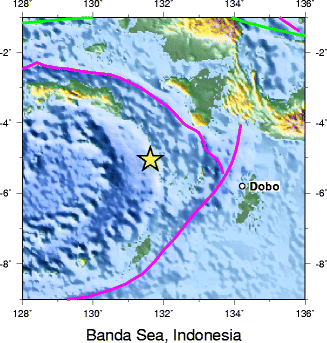
| lat | -5.05 | |
| long | 131.62 | |
| mark | Bullseye1.png | |
| marksize | 40 | |
| position | top | |
| width | 250 | |
| float | right | |
| caption | }} | |
| timestamp | 1938-02-01 19:04:23 | |
| isc-event | 902352 | |
| anss-url | official19380201190422_30 | |
| local-date | ||
| local-time | 04:04 | |
| magnitude | 8.5-8.6 | |
| intensity | ||
| depth | 60 km | |
| location | ||
| type | Oblique-slip | |
| tsunami | Yes, 1.5 m | |
| aftershocks | Yes | |
| casualties | None |
|isc-event = 902352 |anss-url = official19380201190422_30 |local-date = |local-time = 04:04
The 1938 Banda Sea earthquake occurred on February 2 at 04:04 local time with an estimated magnitude of 8.5-8.6 on the moment magnitude scale. Shaking was intense with an assigned Rossi–Forel intensity of VII (Very strong tremor) and intensity of VI (Strong) on the Modified Mercalli intensity scale. This oblique-slip event generated a destructive tsunami of up to 1.5 metres in the Banda Sea region, but there were no deaths.
Tectonic setting
The Banda Sea is located within a very complex tectonic regime that accommodates the convergence between the Australian plate and the Sunda plate. The Molucca Sea plate, Bird's Head plate, Timor plate, and Banda Sea plate all help accommodate the elaborate plate boundary system in the region. This collection of microplates leads to large amounts of seismicity in the area, including the 1852 Banda Sea earthquake which was potentially a 8.8 event, as well as the 1629 Banda Sea earthquake which was also estimated at up to 8.8.
Earthquake
At around 04:00 local time, a large earthquake started to shake the Banda islands. The earthquake was assigned a moment magnitude () of 8.5–8.6 and caused a destructive tsunami of 1.5 m at the Kai islands. The tsunami expected for an earthquake of this size is much greater, such as of those in 1629 and 1852, however this earthquake occurred at a depth of 60 km which impeded much of the ocean floor displacement which leads to a tsunami. Due to its depth, the earthquake was felt strongly in far away Darwin and as far as Merauke and Daly Waters. In Darwin, concrete floors cracked and windows were damaged. This earthquake is of significant scientific interest as it remains a mystery as to precisely which fault produced this earthquake. Some studies consider this earthquake the largest intraslab earthquake on record.
Tsunami
Despite being a large thrust faulting event, the tsunami was rather small. This is assumed to be caused by the 60 kilometer depth. At the Kai islands, runups of 1.5 m were recorded. Beachfront damage was reported across the Tayandu Islands and the entire Banda region.
References
Sources
References
- ISC. (27 June 2022). "ISC-GEM Global Instrumental Earthquake Catalogue (1900–2009)". [[International Seismological Centre]].
- National Geophysical Data Center / World Data Service (NGDC/WDS). (1972). "Significant Earthquake Database". [[National Geophysical Data Center]], [[National Oceanic and Atmospheric Administration.
This article was imported from Wikipedia and is available under the Creative Commons Attribution-ShareAlike 4.0 License. Content has been adapted to SurfDoc format. Original contributors can be found on the article history page.
Ask Mako anything about 1938 Banda Sea earthquake — get instant answers, deeper analysis, and related topics.
Research with MakoFree with your Surf account
Create a free account to save articles, ask Mako questions, and organize your research.
Sign up freeThis content may have been generated or modified by AI. CloudSurf Software LLC is not responsible for the accuracy, completeness, or reliability of AI-generated content. Always verify important information from primary sources.
Report