From Surf Wiki (app.surf) — the open knowledge base
Zólyom County
County of the Kingdom of Hungary
County of the Kingdom of Hungary
| Field | Value |
|---|---|
| native_name | |
| conventional_long_name | Zólyom County |
| common_name | Zólyom |
| subdivision | County |
| nation | the Kingdom of Hungary |
| year_start | 14th century |
| event_end | Treaty of Trianon |
| year_end | 1920 |
| date_end | 4 June |
| image_coat | Zvolen coatofarms.jpg |
| image_map | Zólyom vármegye Magyarországon.svg |
| capital | Besztercebánya |
| coordinates | |
| stat_area1 | 2634 |
| stat_pop1 | 133653 |
| stat_year1 | 1910 |
| today | Slovakia |
| footnotes | Banská Bystrica is the current name of the capital. |
Zólyom county (; ; ; ) was an administrative county (comitatus) of the Kingdom of Hungary. Its territory is now in central Slovakia.
Geography

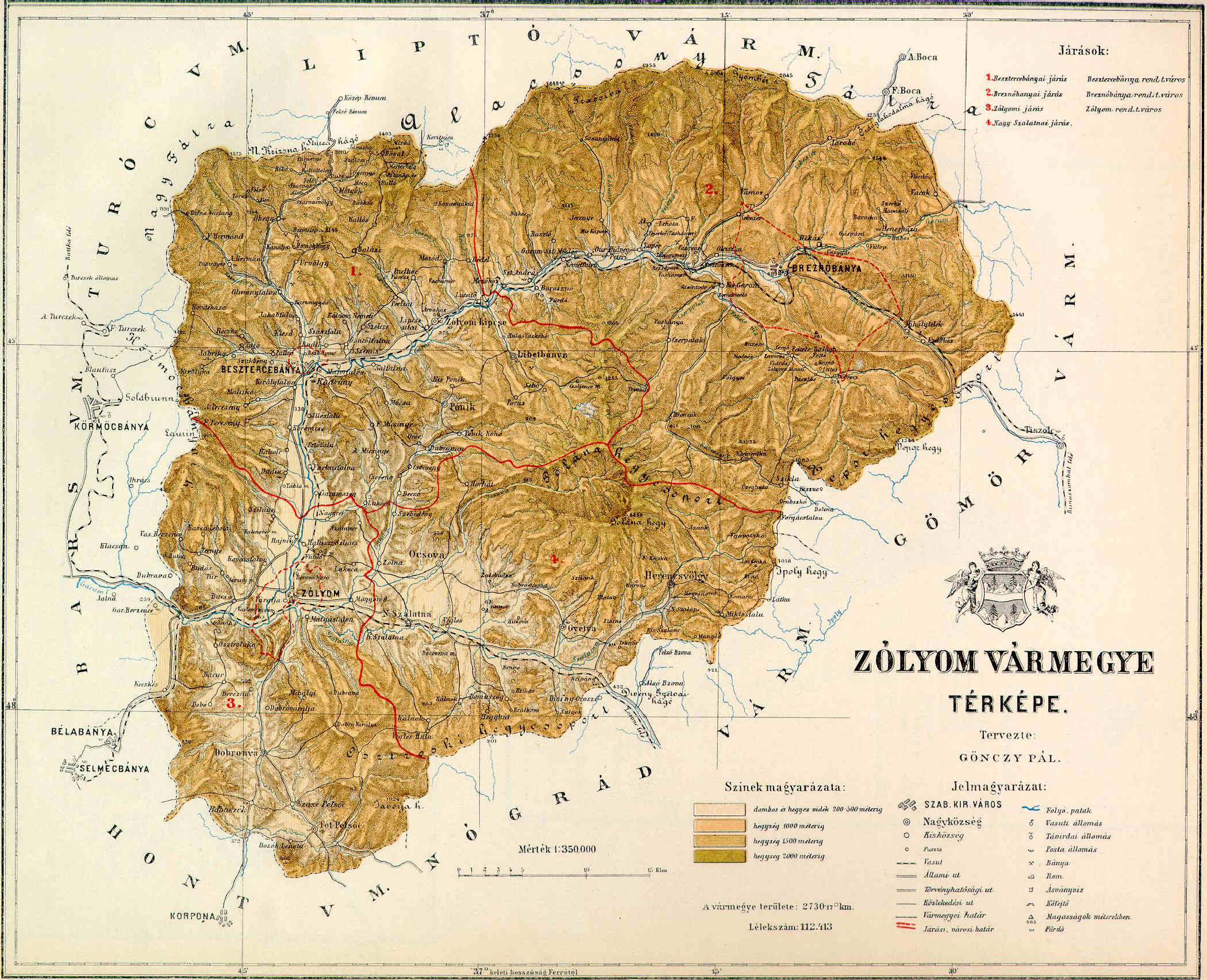
Zólyom county shared borders with the counties of Bars, Turóc, Liptó, Gömör-Kishont, Nógrád and Hont. The county's territory was situated along the central Garam river, approximately between (excluding) Korpona and (including) Breznóbánya. Its area was 2634 km2 around 1910. The county was characterised by extensive mining activities.
Capitals
The capital of the county was the castle of Pusztavár near Zólyom, then from the late 15th century the Zvolen Castle () and from the 1760s the town of Besztercebánya.
History
Zólyom county arose as a Hungarian comitatus in the 14th century, when most parts of the territory were conquered by the Kingdom of Hungary, from a huge royal property (the Vetusolium dominium). Initially, it comprised with a territory of the latter separated Árva, Turóc and Liptó counties.
In the aftermath of World War I, Zólyom county became part of newly formed Czechoslovakia, as recognized by the concerned states in 1920 by the Treaty of Trianon. The Zvolen county (Zvolenská župa) continued to exist until 1927, but it had completely different powers etc. and somewhat different borders. During the existence of the newly created Slovak State (1939–1945), Hron county (Pohronská župa) was created in 1940, whose territory roughly corresponded to that of the Zvolen county. The capital was Banská Bystrica.
Together with the Slovak parts of Hont and Gömör, it became part of the Banská Bystrica Region (Banskobystrický kraj) created in 1948. In 1993, Czechoslovakia was split and the Zvolen county became part of Slovakia.
Demographics

| Census | Total | Slovak | Hungarian | German | Other or unknown | 1880 | 1890 | 1900 | 1910 |
|---|---|---|---|---|---|---|---|---|---|
| 102,500 | 92,621 (93.50%) | 2,664 (2.69%) | 3,007 (3.04%) | 769 (0.78%) | |||||
| 112,413 | 103,648 (92.20%) | 4,549 (4.05%) | 3,268 (2.91%) | 948 (0.84%) | |||||
| 124,420 | 111,050 (89.25%) | 9,078 (7.30%) | 2,945 (2.37%) | 1,347 (1.08%) | |||||
| 133,653 | 113,294 (84.77%) | 16,509 (12.35%) | 2,124 (1.59%) | 1,726 (1.29%) |
| Census | Total | Roman Catholic | Lutheran | Jewish | Other or unknown | 1880 | 1890 | 1900 | 1910 |
|---|---|---|---|---|---|---|---|---|---|
| 102,500 | 64,086 (62.52%) | 36,275 (35.39%) | 1,942 (1.89%) | 197 (0.19%) | |||||
| 112,413 | 71,637 (63.73%) | 38,067 (33.86%) | 2,422 (2.15%) | 287 (0.26%) | |||||
| 124,420 | 80,194 (64.45%) | 40,837 (32.82%) | 2,862 (2.30%) | 527 (0.42%) | |||||
| 133,653 | 87,036 (65.12%) | 42,405 (31.73%) | 3,080 (2.30%) | 1,132 (0.85%) |
Subdivisions

In the early 20th century, the subdivisions of Zólyom county were:
| Districts | District | Capital | Urban districts (rendezett tanácsú város) |
|---|---|---|---|
| Besztercebánya | Besztercebánya (now Banská Bystrica) | ||
| Breznóbánya | Breznóbánya (now Brezno) | ||
| Nagyszalatna | Nagyszalatna (now Zvolenská Slatina) | ||
| Zólyom | Zólyom (now Zvolen) | ||
| Besztercebánya (now Banská Bystrica) | |||
| Breznóbánya (now Brezno) | |||
| Zólyom (now Zvolen) |
Notes
References
References
- "Az 1881. év elején végrehajtott népszámlálás főbb eredményei megyék és községek szerint rendezve, II. kötet (1882)". library.hungaricana.hu.
- "A Magyar Korona országainak helységnévtára (1892)". library.hungaricana.hu.
- "A MAGYAR KORONA ORSZÁGAINAK 1900". library.hungaricana.hu.
- "KlimoTheca :: Könyvtár". Kt.lib.pte.hu.
This article was imported from Wikipedia and is available under the Creative Commons Attribution-ShareAlike 4.0 License. Content has been adapted to SurfDoc format. Original contributors can be found on the article history page.
Ask Mako anything about Zólyom County — get instant answers, deeper analysis, and related topics.
Research with MakoFree with your Surf account
Create a free account to save articles, ask Mako questions, and organize your research.
Sign up freeThis content may have been generated or modified by AI. CloudSurf Software LLC is not responsible for the accuracy, completeness, or reliability of AI-generated content. Always verify important information from primary sources.
Report