From Surf Wiki (app.surf) — the open knowledge base
Waipiʻo Valley
Valley on The Big Island, Hawaii
Valley on The Big Island, Hawaii
| Field | Value |
|---|---|
| name | Waipiʻo Valley |
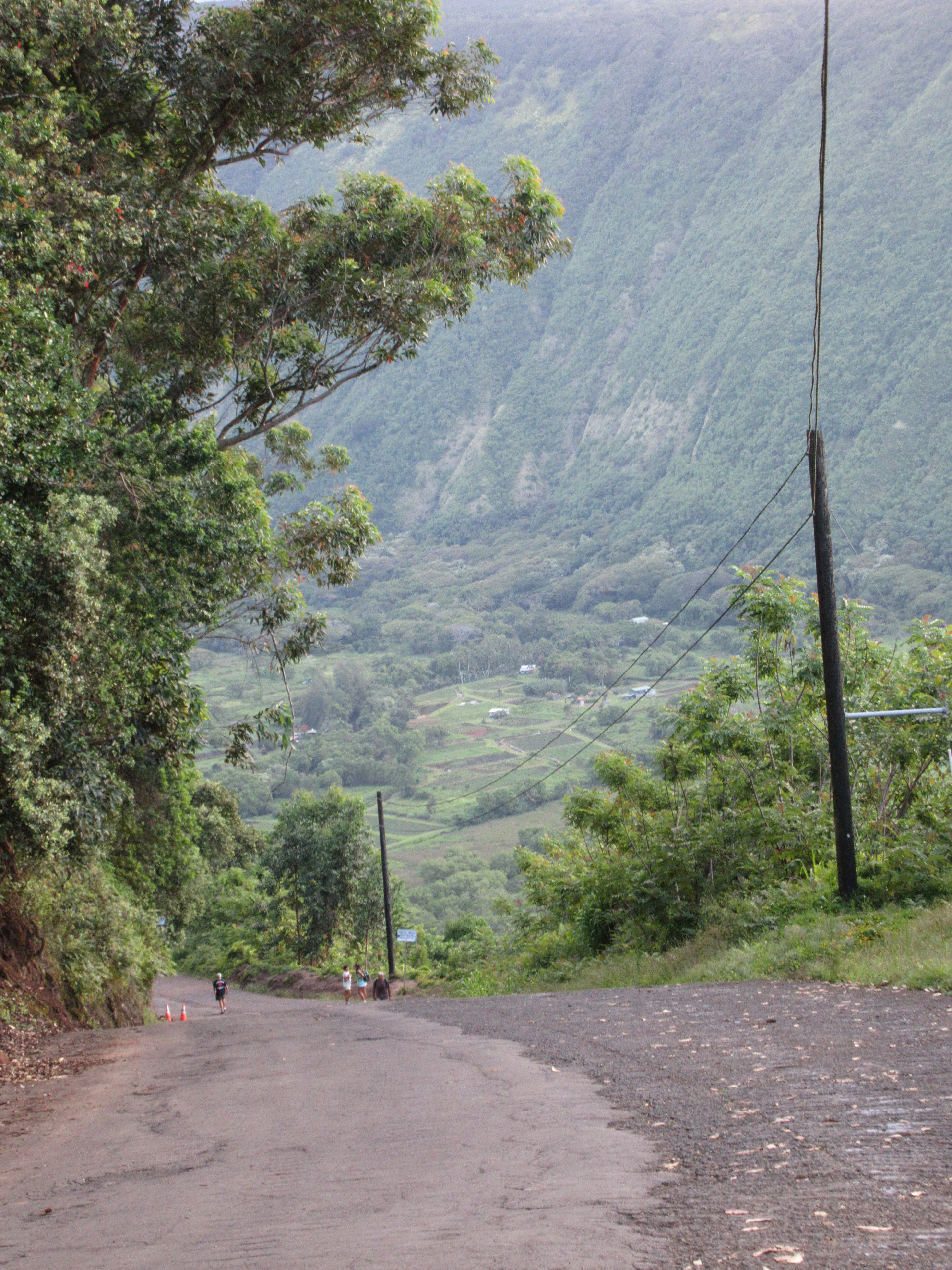
| photo | Waipio Lookout View.jpg |
| photo_size | 235 |
| photo_caption | View from the Waipiʻo Valley lookout. |
| direction | Southwest-Northeast |
| coordinates | |
| map | Hawaii |
| map_size | 235 |
| map_caption | Location on Hawaiʻi Island in Hawaii. |
| label | Waipiʻo Valley |
| label_position | top |
Waipio Valley is a valley located in the Hāmākua District of the Hawaiʻi Island of Hawaii. Wai pio means "curved water" in the Hawaiian language.
Description
The valley floor at sea level is almost 2000 ft below the surrounding terrain. The valley was formed by stream erosion in the weak basalt lava from the Kohala volcano.
The shore line in the valley is a black sand beach, popular with surfers. A few taro farms are located in the valley. Several large waterfalls fall into the valley to feed the river which flows from the foot of the largest falls at the back of the valley out to the ocean.
History and folklore
The valley was the capital and permanent residence of many early Hawaiian aliʻi (chiefs/kings) up until the time of King Umi. This was a place celebrated for its nioi tree (Eugenia reinwardtiana) known as the Nioi wela o Pakaalana ("The burning Nioi of Pakaalana"). It was the location of the ancient grass palace of the ancient "kings" of Hawaiʻi with the nioi stands. The first chief who had a court in this valley was called Kahaimoelea.
At its peak, the valley likely supported 10,000 people on 800 acre of taro. In the 18th century, Kahekili II (king of Maui) raided Waipio and burned the four sacred trees to the ground.
The valley has a role in local Hawaiian folklore as a place where the gateway to Lua-o-Milu (the Underworld) was hidden from view by sand.
The 2006 Kiholo Bay earthquake, caused a cliff at the entrance of the Waipio Valley to collapse and slide into the ocean as well as rock falls on the access road leading to the valley.
Access
A steep road leads down into the valley from a lookout point located on the top of the southern wall of the valley. The road rises 800 ft in 0.6 mi at a 25% average grade, with significantly steeper grades in sections. Some portions of the road can reach up to a 45% grade, which would make Waipio Valley Road the steepest in the world, compared to Baldwin Street's 35%. This is a paved public road but it is open only to 4 wheel drive vehicles. It is the steepest road of its length in the United States. The access to the valley floor via the road is allowed for Big Island residents, county-permitted tour company operators and those seeking to practice their Native Hawaiian traditional or customary rights.
A foot trail called Waimanu or Muliwai Trail leads down a steep path to the Waimanu Valley, which is only accessible by the trail or by boat. The trail is accessible to hikers, who need a Waimanu camping permit from the state unless they do the trek as a strenuous day hike. At the upper end of the valley, Waimanu Gap at 2089 ft elevation leads to the south end of Waimanu Valley.
In popular culture
The valley was the site of the final scene in the 1995 sci-fi film Waterworld, at which the main characters found dry land.
Image gallery
Image:WaipioValley.jpg|View of the back of Waipio Valley. Image:Waipio Valley uphill.JPG|View of the back of Waipio Valley. Image:Waipio waterfall.jpg|Hiʻilawe Waterfall at the back of Waipio Valley. Image:2006 Hawaii earthquake.JPG|Waipio Valley cliff falling in during the 2006 Kiholo Bay earthquake.
References
References
- [http://ulukau.org/cgi-bin/hpn?e=q-0mahele--00-0-0--010---4----dtt--0-0l--1en-Zz-1---20-about-waipi%27o--00031-00010escapewin-00&a=d&c=mahele&cl=search&d=HASH595340c6c5afff98ac906f lookup of Waipi{{okina}}o] on Hawaiian place names web site
- "Four Stages showing the development of Waipi{{okina}}o and Waimanu Valley". [[Bishop Museum]].
- Hitt, Christine. (April 21, 2019). "Learning Hawaii's history may be key to avoiding cultural insensitivity". [[Los Angeles Times]].
- "History of the Waipi{{okina}}o Valley".
- (August 1995). "From Ancient Times to Today, Water Has Defined Waipi`o Valley". Environment Hawaii.
- Thrum, Thomas. (1907). "Hawaiian Folk Tales". [[A. C. McClurg]].
- Dr. Edmund W. Medley. (2006-12-15). "GEOLOGICAL ENGINEERING RECONNAISSANCE OF DAMAGE RESULTING FROM THE OCTOBER 15, 2006 EARTHQUAKES, ISLAND OF HAWAII, HAWAII, USA". Department of Civil and Environmental Engineering [[University of California at Berkeley]].
- "The 10 Steepest Streets In America". BuzzFeed, Inc..
- (October 20, 2014). "Is This Hawaiian Street the World's Steepest Road?". [[Condé Nast]].
- "Waipio Valley Road in HI is the steepest road in the USA". dangerousroads.org.
- "4 Steep U.S. Streets That Will Make Your Palms Sweat". Inboxlab, Inc..
- Summerson, J: "The Complete Guide to Climbing (by Bike)", page 165. Extreme Press, 2007
- (2023-07-14). "The dispute over Waipi{{okina}}o Valley raises questions of belonging in Hawaiʻi". Hawai{{okina}}i Public Radio.
- (2017-07-01). "Waipi{{okina}}o Valley Beach Hiking Trail {{!}} Hawaii Big Island Hikes". Go Hike It.
- Lloyd J. Soehren. (2004). "lookup of Waimanu Gap". Ulukau, the Hawaiian Electronic Library.
- [https://www.imdb.com/title/tt0114898/locations Locations. Waterworld (1995) on IMDB]
- (October 1, 2024). "Waipi‘o Valley: How to visit and what to see".
This article was imported from Wikipedia and is available under the Creative Commons Attribution-ShareAlike 4.0 License. Content has been adapted to SurfDoc format. Original contributors can be found on the article history page.
Ask Mako anything about Waipiʻo Valley — get instant answers, deeper analysis, and related topics.
Research with MakoFree with your Surf account
Create a free account to save articles, ask Mako questions, and organize your research.
Sign up freeThis content may have been generated or modified by AI. CloudSurf Software LLC is not responsible for the accuracy, completeness, or reliability of AI-generated content. Always verify important information from primary sources.
Report