From Surf Wiki (app.surf) — the open knowledge base
Šar Mountains
Mountain range in Southeast Europe

Mountain range in Southeast Europe
| Field | Value |
|---|---|
| name | Šar Mountains |
| other_name | Sharr Mountains |
| photo | Small Turk and Titov Vrv.jpg |
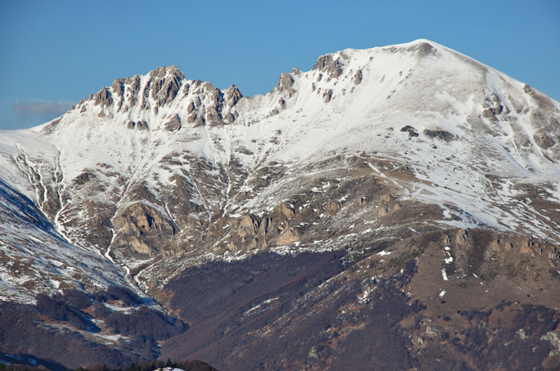
| photo_caption | Titov Vrv (back) and Small Turk (front), the tallest peaks of Šar Mountains |
| highest | Titov Vrv |
| highest_location | North Macedonia |
| elevation_m | 2748 |
| native_name | |
| map_image | Macedonia relief Sar location map.jpg |
| location | Kukës and Dibër Counties – Albania |
| country | |
| range_coordinates |
Ferizaj and Prizren Districts – Kosovo
Polog Valley – North Macedonia
The Šar Mountains (; Шар-планина; colloquially also Šara, ) or Sharr Mountains (, ) is a mountain range in Southeast Europe, extending into several countries from southern Kosovo, to northwestern North Macedonia, to northeastern Albania. The sections in Kosovo (Sharr Mountains National Park) and North Macedonia (Šar Planina National Park) are national parks. Rugged and barren, the mountains are among the highest in the Balkans, with 30 peaks higher than 2500 m.
Etymology
In antiquity, the mountains were known as Scardus, Scodrus, or Scordus (το Σκάρδον ὂρος in Polybius and Ptolemy). It is considered of Indo-European origin (cf. 'steep'),
The theory according to which the modern Sharr/Šar represents an evolution of the ancient name Scardus through Albanian sound changes is untenable on the basis of current historical-linguistic research. Sharr/Šar rather can be traced to meaning 'saw', denoting the jagged peaks and 'saw-toothed ridge'. In the early 16th century, it was recorded that the mountain was called "Catena Mundi" (Latin for "the chains of the world").
Sometimes the range is called "Carska Planina" (, "Tsar's Mountain"), as a reference to the capitals (Prizren and Skopje), courts (Nerodimlje, Pauni, Svrčin, etc.) and monasteries (monastery of the Holy Archangels) of the Serbian Empire located in the region. In the medieval period, Serbs called the mountain "Mlečni" (), because of the major milk production on the mountain and the vast herds of cattle, goats and sheep. In the golden bull issued by Emperor Dušan on 20 September 1349, he says: "I also bequest all of mine estates and areas around the Mlečni Mountain ("Milk Mountain"), the Durlev estates and all the metochions and all the wealth and treasure of that region". The bull is kept in the Dubrovnik Archive.
Borders
The mountain borders extend from the city of Prizren, following the two rivers of the Prizren Bistrica and the Lepenac. In the east, it passes by the town of Kaçanik through the Kaçanik Gorge and into North Macedonia via the Polog Valley. The border passes near the Vardar spring called Vrutok and enters near the Mavrovo Valley. There the Radika river separates the mountain massif from the higher Mount Korab. After that, the border is mounting, reaching the point of junction of three state borders: Kosovo, North Macedonia and Albania. The border now follows the road to the small, mountainous, town of Restelicë, the rivers of Globocica, Plava and the White Drin and finally reaches the city of Prizren.
Geographical characteristics


The Šar Mountains have a total area of 1,600 km2. 56,25% of that area is in North Macedonia, 43.12% in Kosovo, and 0,63% in Albania. There are three plains: Sirinić, Vraca and Rudoka. The system is about 80 km long and 10 - wide.
The mountain massif was formed in the Tertiary Period. The peaks are covered with ice and snow.
It includes several high peaks:
- Titov Vrv (2747 m)
- Mal Turčin (2707 m)
- Bakardan (2704 m)
- Borislavec (2675 m)
- Velika Rudoka (2660 m) – the highest mountain of Kosovo, and also the highest mountain of Serbia according to the view held by the government of Serbia.
- Peskovi – east summit (2651 m)
- Peskovi – west summit (2641 m)
- Mala Rudoka (2629 m)
- Džini Beg (2610 m)
- Ezerski Vrv (2604 m)
- Karabunar (2600 m)
- Trpeznica (2590 m)
- Maja e zezë (2585 m)
- Golema Vraca (2582 m)
- Guzhbaba (2582 m)
- Isa Aga (2555 m)
- Black Peak (2536 m)
- Kobilica (2528 m)
- Piribeg (2524 m)
- Ljuboten (2498 m)
- Maja Livadh (2497 m)
- Maja e Begut (2493 m)
- Zallina (2493 m)
- Mala Vraca (2483 m)
- Guri i Çarë (2466 m)
- Kleç (2414 m)
- Kara Nikolla (2409 m)
- Maja Koritnik (2393 m)
- Tumba Peak (2346 m)
- Bardhalevë (2334 m)
- Kulla Peak (2314 m)
- Oshlak (2212 m)
- Gemitash (2183 m)
- Kallabak (2174 m)
- Kamenkullë (2117 m)
- Ksulje e Priftit Peak (2092 m) – tripoint
- Pashallora (2092 m)
There are 30 peaks higher than 2,500 m and 70 above the 2,000 m.
The Šar Mountains extend to Mount Korab (2764 m) in the southwest, and pass into northeastern Albania with very small part (0.63% of the entire length).
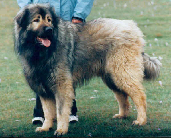
Vegetation on the mountains includes crops up to around 1000 m, forests up to 1700 m, and above that lie high pastures which encompass around 550 km2. The Šar Mountains are the largest compact area covered with pastures on the European continent. The dog breed Šarplaninac comes from this area.
The snowy peaks of the Šar Mountains are depicted on the coat of arms of the city of Skopje, which in turn is incorporated in the city's flag.
History
The remains of the Shiroka complex are located near Mushtishtë. The complex originates from the period between the 10th and the 7th century BC, but also has medieval remnants. In Roman period, the mountain was a tripoint between the provinces of Dalmatia, Moesia and Macedonia. The route of an ancient road crossed the Scardus from 169 BC. The road was later named Velji ("Great") or Prizren road. Lisinski road was built. Remnants of the fort on the Kradište hill, near Prizren, dates from the 2nd to the 6th century and testifies the change of civilizations in this region: it started in the pre-Roman period, then became a Roman town and later a Byzantine one. Locality of Ravna Gora, predating the 6th century, where Slavs later cremated their dead, is situated in the area. Medieval military complex of Petrič Fortress, which consists of two fortresses, Little Petrič and Great Petrič, is also preserved. Remains of the Višegrad Fort, older part of the Prizren Fortress, are located in the gorge of the Bistrica river. When King Milutin donated lands to the Our Lady of Ljeviš church, he also donated the Višegrad Fort to serve as an Prizren's defence outpost. Emperor Dušan later expanded the fort to the river and built his endowment, the Monastery of the Holy Archangels.
There are 45 Serbian Orthodox monasteries on the slopes of the mountain, dating from the 12th to the 16th century. Additional 32 monasteries were damaged or demolished during the NATO bombing of Serbia in 1999 and in the later years. Church of the Dormition of the Mother of God in the village of Gotovuša in Sirinićka Župa was built in 16th century. It was destroyed later and rebuilt in the second half of the 19th century. During the works in churchyard in the 2010s a floor mosaic was discovered from the much older church from the Byzantine period.
Šar Mountains in Kosovo
.jpg)
The Šar Mountains are located in the south and south-east of Kosovo, where 43.12% of the range is located. Many alpine and glacial mountain lakes are found on the Kosovar part of the Šar Mountains, especially south of the town of Dragash, the area of Shutman and the region north of Vraca. The Brezovica ski resort, with an elevation of 900 m to 2524 m above sea level, is located north-east of the mountains.
The mountain range in Kosovo is divided into three main zones: The zone of Ljuboten and Brezovica, the central zone of Prizren and the zone of Opoja and Gora.

The mountains border the Kosovo Plain to the north-east and the Metohia Valley in the northwest. Kosovo consists of the most eastern tip and the most northern part of the mountain ridge. The Ljuboten peak and the mountain of Skopska Crna Gora create the Kaçanik Gorge in Kosovo. The Šar Mountains are split from the Nerodimka Mountain by the Sirinić Valley. The Šar National Park is located in Kosovo. Villages and towns that are found near the mountain are:
- Prizren, largest city located at the foot of the mountains.
- Kaçanik
- Dragash
- Brezovica
- Štrpce
Lakes in the Kosovo part of the Šar Mountains are:
- Jazhincë Lake
- Small Jazhincë Lake
- Shutman Lake
- Lower Defsko Lake
- Livadh Lake
- Black Vir Lake
- Donji Vir Lake
- Blateško Lake
- Upper Defsko Lake
- Dinivodno Lake
In total, there are 70 glacial lakes on the Šar Mountains.
Sharr Mountains National Park in Kosovo
Main article: Sharr Mountains National Park
History
Sharr Mountains National Park is a national park of Kosovo and covers an area of 534.69 km2 on the northern slopes of the Šar Mountains as well as the mountains of Oshlak and Jezercë. The National Park "Šar-Planina Mt." was proclaimed in 1986 within the temporary boundaries of 390.00 km2, and opened in 1995. The final boundaries of the Park were expanded in 2012 to cover an area of 534.69 km2.
Geography
The park occupies the northwest sections of the mountain's main massif, including the highest peak, Bistra, an spreads over the sections of Prevalla, Oshlak, Ostrovica and Kodža Balkan. The park encompasses several different types of topographic relief: glacial (cirques, moraines and glacial lakes), periglacial (snow cirques, sliding blocks, "tundra mosaic" type of micro-shapes in the deposits of silt), karstic and fluvial. There are numerous rivers, springs, creeks, bogs and lakes.
Plant life
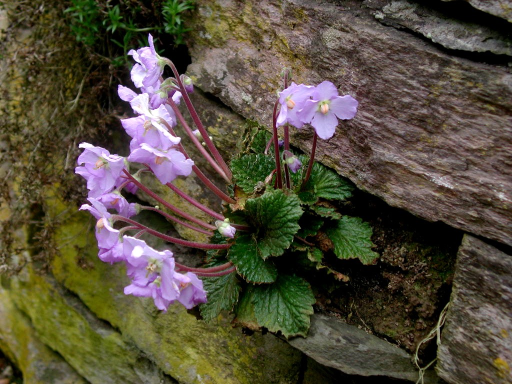
In total, there are 1,800 plant species. The mountain is inhabited by 175 strictly protected plant species, 247 Balkan endemites and 18 plants which can be found only on Šar Mountains. The park includes the endemic relict Macedonian Pine and white-bark pine, as well as the mugo pine and Alpine rose. Other perennial plants include King Alexander's yarrow (Achillea alexandri-regis), Nikolić's silene (Heliosperma nikolicii), Bornmuellera dieckii, Šar carnation (Dianthus scardicus Wettst.), Doerfler's cinquefoils and Macedonian meadow saffron (Colhicum macedonicum). One of the relic species is Natalie's ramonda. It went extinct from the most of Europe during the last ice age and today grows as an endemic species in several gorges in Serbia, North Macedonia and Greece. It has been chosen as the Serbian symbol for the Armistice Day.
Animal life
Rusenica locality on the mountain has been in the first level of protection, as the strict reserve of nature, since 1955. It is one of the rare habitats of Balkan lynx, the largest European cat. It is estimated that on the entire Balkans there are no more than 100 specimens. European pond turtle and Hermann's tortoise, only two European species of freshwater turtles, live on the mountain. There are 147 butterfly species (excluding moths), 45 amphibians and reptilians and 37 mammalian species. Other animals include bear, chamois, wolf, roe deer, wild boar and other species including many bird species. The national park contains 720 chamois while the Opoja and Gora region contains 600 chamois. The National Park is administered by the Ministry of Environment and Spatial Planning (MESP).
References
Bibliography
Alpinism
Biology
References
- Dimitrije Bukvić. (31 July 2017). "Trezor Evrope". [[Politika]].
- Selçuk Biricik, Ali. (2012). "The 2nd International Balkan Conference (IBAC 2012): 'The Balkans at a Crossroads: Evaluating Past, Reading Present, Imagining Future' on 11-14 October 2012 in Tirana; organized by Istanbul University in collaboration with the University of Tirana and Epoka University". [[İstanbul University]].
- (2021-06-30). "СОБРАНИЕТО ГО УСВОИ ЗАКОНОТ СО КОЈ ШАР ПЛАНИНА СТАНУВА НАЦИОНАЛЕН ПАРК".
- Sir William Smith. (1872). "Dictionary of Greek and Roman Geography: Isabadius-Zymethus. 1857". John Murray.
- Borel, Francesco Rubat. (2005). "Lingue e scritture delle Alpi occidentali prima della romanizzazione. Stato della questione e nuove ricerche". Société Valdôtaine de Préhistoire et d’Archéologie.
- (2016). "Die albanische Autochthoniehypothese aus der Sicht der Sprachwissenschaft".
- Lafe, Genc. (2022). "Albanologu i arvanitëve "Atje kam u shpirtin tim..."". [[Academy of Sciences of Albania]].
- Veselinović, Andrija. (2001). "Srpske dinastije".
- (6 June 2018). "Да ли знате? - Како се некад звала Шар-планина". Politika.
- Rista Nikolić. (1912). "Glacijacija Šar Planine i Koraba".
- Živko Stefanovski. "Šar Planina". Napredok.
- "National Park Šar-Mountain". brezovica-ski.com.
- Official portal of the city of Skopje: [http://www.skopje.gov.mk/EN/DesktopDefault.aspx?tabindex=0&tabid=34 City symbols]. – Retrieved on 13 May 2009.
- Zeqir, Veselaj. (1 January 2013). "Extension of national park "Sharri" boundaries and its significance for nature conservation in Kosovo". Natura Montenegrina.
- (5 October 2015). "Zakon o nacionalnim parkovima (National parks law)".
- Aleksandra Mijalković. (18 June 2017). "O očuvanju naše prirodne baštine: najbolja zaštita u naconalnim parkovima". [[Politika]]-Magazin.
- [http://www.ks-gov.net/mmph/shqip/depart/parkn_pz.htm Ministry of Environment and Spatial Planning](''in Albanian'')
This article was imported from Wikipedia and is available under the Creative Commons Attribution-ShareAlike 4.0 License. Content has been adapted to SurfDoc format. Original contributors can be found on the article history page.
Ask Mako anything about Šar Mountains — get instant answers, deeper analysis, and related topics.
Research with MakoFree with your Surf account
Create a free account to save articles, ask Mako questions, and organize your research.
Sign up freeThis content may have been generated or modified by AI. CloudSurf Software LLC is not responsible for the accuracy, completeness, or reliability of AI-generated content. Always verify important information from primary sources.
Report