From Surf Wiki (app.surf) — the open knowledge base
San Bartolomé de Tirajana
| Field | Value |
|---|---|
| name | San Bartolomé de Tirajana |
| translit_lang1_type | Spanish |
| translit_lang1_info | San Bartolomé de Tirajana |
| settlement_type | Municipality |
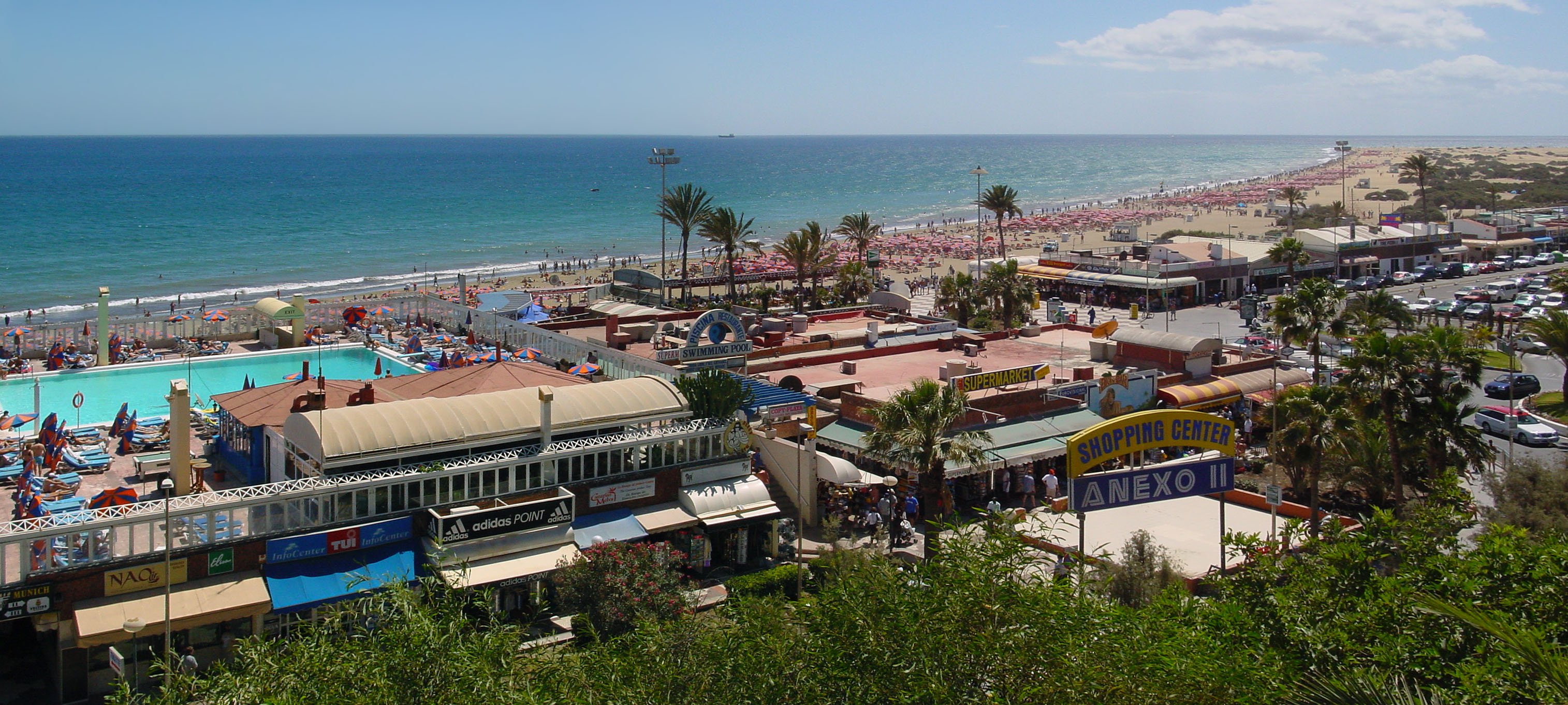
| image_skyline | San bartolomé de Tirajana 04.JPG |
| image_caption | San Bartolomé de Tirajana |
| image_flag | Bandera_de_Tunte.png |
| image_shield | Escudo de San Bartolomé de Tirajana (Las Palmas).svg |
| image_map | Gran Canaria municipio San Bartolomé de Tirajana.svg |
| map_caption | Municipal location in Gran Canaria |
| pushpin_map | Spain Province of Las Palmas#Canary Islands#Spain with Canary Islands |
| pushpin_map_caption | Location in the province of Las Palmas |
| coordinates | |
| subdivision_type | Country |
| subdivision_name | Spain |
| subdivision_type1 | Autonomous Community |
| subdivision_name1 | Canary Islands |
| subdivision_type2 | Province |
| subdivision_name2 | Las Palmas |
| subdivision_type3 | Island |
| subdivision_name3 | Gran Canaria |
| leader_party | Agrupación de Vecinos de San Bartolomé de Tirajana |
| leader_title | Mayor |
| leader_name | Marco Aurelio Pérez Sánchez |
| area_footnotes | |
| area_total_km2 | 333.13 |
| elevation_footnotes | (AMSL) |
| population_as_of | |
| population_footnotes | |
| population_total | |
| population_density_km2 | auto |
| timezone1 | CET |
| utc_offset1 | +0 |
| timezone1_DST | CEST (GMT +1) |
| utc_offset1_DST | +1 |
| postal_code_type | Postal code |
| postal_code | 35290 |
| area_code | 928 & 828 |
| website | www.maspalomas.com |
San Bartolomé de Tirajana is a village and a Spanish municipality in the south-western part of the island of Gran Canaria in the Las Palmas province in the Canary Islands. With an area of 333.13 km²,
The municipality contains the large beach resorts of Maspalomas, including Playa del Inglés and San Agustín, and the Pilancones natural park. The municipal capital, the village of San Bartolomé de Tirajana is situated in the mountains, 17 km from the coast and 27 km south-west of Las Palmas, at about 900 m elevation. Most of the population lives along the Atlantic coastline. The GC-1 motorway passes through the southern part of the municipality, and connects it with Las Palmas de Gran Canaria and the Gran Canaria Airport.
Location
Located in the south of the island, 54.5 kilometers from the island's capital, the municipality has a triangular shape with a vertex in the interior and a wide base that covers a good part of the southern coast of Gran Canaria.
With an area of 333.13 km², it is the largest municipality on the island, covering more than a fifth of the island's surface area.
The municipal capital, the rural nucleus of Tunte, is located at 850 meters above sea level, reaching the maximum municipal level at 1,957.3 meters above sea level at the elevation known as Morro de la Agujereada.
Orography
The centre of the coast of the municipality is characterised by its long and wide golden sand beaches, as well as the dune field of Maspalomas and its brackish water pool. The northern end of the coast is, on the contrary, rocky, and the southern end is cliff.
Above the coast there is a wide, fully developed coastal plain, which gradually rises up and, furrowed by deep ravines, heads towards the mountains in the centre of the island.
Evolution of urban land, according to the Cadastre (2010 data): urban land in 2006: 1586 hectares; urban land in 2007: 1612 hectares; urban land in 2008: 1635 hectares; urban land in 2009: 1649 hectares; urban land in 2010: 1657 hectares, representing 5.2% of the total land of the municipality.
Climate
The weather conditions are given by the leeward position of the island and, therefore, to the protection of the humid winds of the northeast. This results in low and concentrated rainfall in the winter months and pleasant temperatures almost all year round.
The average annual temperature is 15,8 °C, with January being the coldest month at 12,1 °C and August the hottest at 20,5 °C. As for rainfall, the average is 307 mm per year.
This justifies the fact that the high tourist season extends from September-October to April, the time of year when the mild temperatures make the island a destination for European tourism.
Nature
Protected areas
The municipality has a large part of its surface area included in the Canary Islands Network of Natural Protected Areas. The Riscos de Tirajana Natural Monument, the Pilancones Natural Park, the Fataga Protected Landscape, the Maspalomas Dunes Special Nature Reserve and the Juncalillo del Sur Site of Scientific Interest are all within its boundaries. In addition, it shares with the neighbouring municipalities the Nublo Rural Park and the Los Marteles Special Nature Reserve.
All these areas are also included in the Natura 2000 Network as Special Areas of Conservation - SACs, to which the Amurga and Taurus massifs are added, as well as the coastal strip from the tip of Tarajalillo to that of Maspalomas due to the existence of underwater tallow meadows known as sebadales. The surface of the protected landscape of Fataga, Pilancones and the rural park of El Nublo are also Special Protection Areas for Birds -SPA-.
The municipality also has the public utility mountains of San Bartolome, La Plata and Maspalomas, as well as Montaña del Rey.
Economy
Tourism is the single crop of the coastal area, while as we go up, we see cooler weather, more fertile land and more agricultural activity.
Rustic land (29,615 hectares), divided into 9,369 cadastral plots: pasture and uncultivated land 85.90%; slow-growing timber species 9.5%; irrigated land 2.3%; fruit trees 1.1%; dry farming 1%. (Source: Cadastre, 2009)
Tourism, the main economic activity in the municipality, is currently in a phase of adaptation. Different studies and organized plans that attend to the current demand and elaborated with the participation of different institutions such as the ULPGC, City Hall, Cabildo and the Government of the Canary Islands, are being put into practice in order to highlight the identity of the municipality and its innumerable values.
They also attend to the modernization of the accommodation plant that, being a pioneer municipality at a tourist level, shows in its urban structure the passage of time, trying to preserve the artistic or heritage value and replacing what has become obsolete.
These plans include new buildings such as a multi-adventure theme park and a high performance sports centre linked to the world of motor sports in Punta de Tarajalillo. Also in Punta de Tarajalillo, the creation of the Wake Park Feliz theme park, dedicated mainly to the offer of water sports.
Historical population
| 1991 | 24451 | 1996 | 35443 | 2001 | 34515 | 2002 | 43403 | 2003 | 45559 | 2004 | 44115 | 2013 | 56698
Settlements
A
- Agualatente
- Aldea Blanca
- Arteara
- Ayacata
- Ayagaures B
- Bahia Feliz
- Berriel C
- Calderin
- Campo Internacional
- El Canalizo
- Casas Blancas
- Los Caserones de Fataga
- Castillo del Romeral
- Los Cercados
- Cercados de Araña
- Cercados de Espino
- Chira
- Ciudad de Lima
- La Culata F
- Fataga
- Las Filipinas
- La Florida H
- Hoya Gercia
- Hoya Grande
- Hoya de Tunte
- Los Hortigones
- Huesa Bermeja
- La Humbria J
- Juan Grande L
- Lomito de Taidía
- Lomo de la Palma M
- Maspalomas
- El Matorral
- Media Fanega
- Los Meloneras
- La Mimbre
- La Montaña
- Montaña La Data
- Montaña de Rosiana
- Monteleon
- El Moral P
- El Pajar
- Los Palmitos
- Pasito Blanco
- Pedrazo
- Perera
- La Plata
- Playa del Aguila
- Playa del Inglés R
- Risco Blanco
- Risco la Candelilla
- Los Rodeos S
- El Salobre
- San Agustín
- San Fernando
- Santa Águeda
- El Sequero
- Los Sitios
- Sonnenland T
- El Tablero
- Taidía
- Tarajalillo
- Las Tederas
- Trejo
- Tunte (San Bartolomé de Tirajana)
Education
The British School of Gran Canaria maintains its South Campus in this municipality.
Climate
It is located on the leeward portion of the island. Humid winds cover the northeast in the summer months. Precipitation is lower than the northern part of the island and temperatures are slightly higher than in the north all year round.
Sister cities
- Alajuela, Costa Rica
- Elche, Spain
- Segovia, Spain
References
References
- [http://www.gobiernodecanarias.org/istac/jaxi-istac/menu.do?uripub=urn:uuid:fbc0bdc8-cacb-43b8-a5cb-a93f745dcff6 Instituto Canario de Estadística], area
- link. (2014-04-24 , population)
- "ISTAC: Estadísticas de la Comunidad Autónoma de Canarias".
- "IDECanarias visor 4.5.1".
- "Clima San Bartolomé de Tirajana: Temperatura, Climograma y Tabla climática para San Bartolomé de Tirajana - Climate-Data.org".
- (2018-09-04). "Gran Canaria".
- "Los espacios protegidos Natura 2000 en España".
- "IDECanarias visor 4.5.1".
- "[http://bs-gc.com/en/contact Contact]." [[The British School of Gran Canaria]]. Retrieved on April 8, 2015. "South Campus Address C\ Mar de Azor, 3 El Hornillo 35100 San Bartolomé de Tirajana Las Palmas"
This article was imported from Wikipedia and is available under the Creative Commons Attribution-ShareAlike 4.0 License. Content has been adapted to SurfDoc format. Original contributors can be found on the article history page.
Ask Mako anything about San Bartolomé de Tirajana — get instant answers, deeper analysis, and related topics.
Research with MakoFree with your Surf account
Create a free account to save articles, ask Mako questions, and organize your research.
Sign up freeThis content may have been generated or modified by AI. CloudSurf Software LLC is not responsible for the accuracy, completeness, or reliability of AI-generated content. Always verify important information from primary sources.
Report