From Surf Wiki (app.surf) — the open knowledge base
Rennesøy
Former municipality in Rogaland, Norway
Former municipality in Rogaland, Norway
| Field | Value | |||
|---|---|---|---|---|
| name | Rennesøy | |||
| former | yes | |||
| former_name | Rennesø herred | |||
| image_skyline | Askjesundet bru.jpg | |||
| image_caption | View of the Askjesund Bridge in Rennesøy | |||
| idnumber | 1142 | |||
| county | Rogaland | |||
| district | Ryfylke | |||
| capital | Vikevåg | |||
| established | 1 Jan 1838 | |||
| preceded | none | |||
| disestablished | 1 Jan 2020 | |||
| succeeded | Stavanger Municipality | |||
| demonym | Rennesøybu | |||
| language | Neutral | |||
| coatofarms | Rennesøy komm.svg | |||
| webpage | www.rennesoy.kommune.no | |||
| mayor | Dagny Sunnanå Hausken | |||
| mayor_party | Sp | |||
| mayor_as_of | 2011 | |||
| area_rank | 404 | |||
| area_total_km2 | 65.51 | |||
| area_land_km2 | 64.90 | |||
| area_water_km2 | 0.61 | |||
| area_water_percent | 0.9 | |||
| population_as_of | 2017 | |||
| population_rank | 207 | |||
| population_total | 4,892 | |||
| population_density_km2 | 75.4 | |||
| population_increase | 38.7 | |||
| coordinates | ||||
| utm_zone | 32V | utm_northing = 6555899 | utm_easting = 0312855 | geo_cat = adm2nd |
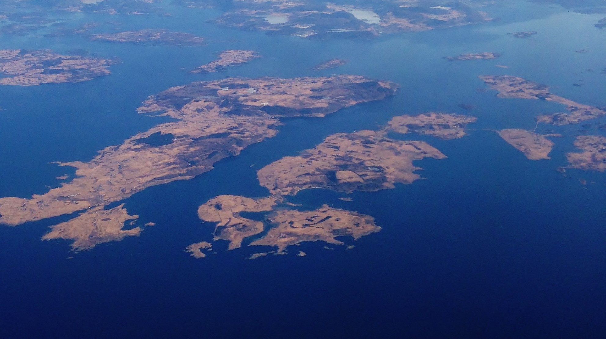
Rennesøy is a former municipality in Rogaland county, Norway. It was merged into Stavanger municipality on 1 January 2020. It was located in the traditional district of Ryfylke. The administrative centre of the municipality is the village of Vikevåg. Other villages in Rennesøy included Askje and Sørbø. The municipality encompassed a number of islands on the south side of the Boknafjorden, north of the city of Stavanger.
At the time of its dissolution, the 66 km2 municipality was the 404th largest by area out of the 422 municipalities in Norway. Rennesøy was the 207th most populous municipality in Norway with a population of 4,892. The municipality's population density is 75.4 PD/km2 and its population has increased by 38.7% over the last decade.
General information

The parish of Rennesø was established as a municipality on 1 January 1838 (see formannskapsdistrikt law). On 1 July 1884, the municipality was split in two with the islands of Mosterøy, Klosterøy, Fjøløy, Kvitsøy, and the western part of Åmøy forming the new municipality of Mosterøy, and the islands of Rennesøy and Brimse remained as Rennesøy municipality. This split left Rennesøy with 1,092 residents, less than half of its previous population. The island of Kvitsøy later became an independent municipality of its own.
On 1 July 1918, the Hanasand area of the neighboring municipality of Finnøy (population: 72) that was located on the island of Rennesøy was transferred to Rennesøy municipality.
During the 1960s, there were many municipal mergers across Norway due to the work of the Schei Committee. On 1 January 1965, the municipality of Mosterøy was merged back into Rennesøy. Prior to the merger, Rennesøy had 1,370 residents.
On 1 January 2020, the municipalities of Finnøy, Rennesøy, and Stavanger were merge into one, large municipality called Stavanger.
Name
The municipality (originally the parish) is named after the main island of the municipality, Rennesøy (). The meaning of the first element is unknown. One possibility is that it comes from the word which means "snout", likely referring to the shape of the mountain Hodnafjellet on the southeast part of the island. The last element is which means "island". Historically, the name of the municipality was spelled Rennesø. On 3 November 1917, a royal resolution changed the spelling of the name of the municipality to Rennesøy. The letter y was added to the end of the word to "Norwegianize" the name (ø is the Danish word for "island" and øy is the Norwegian word).
Coat of arms
The coat of arms was granted on 20 February 1981. The official blazon is "Azure, two crosiers addorsed argent" (). This means the arms have a blue field (background) and the charge is a set of two crosiers standing vertically and mirroring each other. The charge has a tincture of argent which means it is commonly colored white, but if it is made out of metal, then silver is used. The blue represents the ocean, an important feature for this island municipality. The crosiers represent the importance of Norway's oldest and best preserved monasteries, Utstein Abbey, located in the municipality. It was originally an Augustinian monastery, its abbot having a crozier as its symbol. Since Basel, Switzerland already had a crozier on its coat of arms, Rennesøy chose a design with two of them so that it would be different. The arms were designed by Svein Magnus Håvarstein. The municipal flag has the same design as the coat of arms.
Churches
The Church of Norway had two parishes (sokn) within the municipality of Rennesøy. It was part of the Tungenes prosti (deanery) in the Diocese of Stavanger.
| Parish (sokn) | Church name | Location of the church | Year built |
|---|---|---|---|
| Mosterøy | Askje Church | Askje, Mosterøy island | 1846 |
| Utstein Church | Klosterøy island | 1280 | |
| Vestre Åmøy Chapel | Åmøy island (western side) | 1953 | |
| Rennesøy | Hausken Church | Vikevåg, Rennesøy island | 1857 |
| Sørbø Church | Sørbø, Rennesøy island | 1130 |
Geography
The island municipality sat on the south side of the large Boknafjorden. It consists of about 80 islands, most of which are uninhabited. The main islands are Rennesøy, Mosterøy, Klosterøy, Fjøløy, Sokn, Bru, Brimse, and the western part of Åmøy (the eastern part is part of Stavanger municipality). All of the main islands are connected together and to the mainland by a series of bridges and tunnels (except for Brimse which has a ferry connection). The Fjøløy Lighthouse is located in the northwestern part of the municipality, lighting a main shipping channel to Stavanger.
Population
|1865|2453 |1875|2477 |1891|1086 |1900|1110 |1910|1003 |1920|1116 |1930|1260 |1946|1485 |1951|1483 |1960|1438 |1970|2079 |1980|2299 |1990|2561 |2000|3111 |2010|4035 |2019|4847
Government
While it existed, this municipality was responsible for primary education (through 10th grade), outpatient health services, senior citizen services, unemployment, social services, zoning, economic development, and municipal roads. During its existence, this municipality was governed by a municipal council of directly elected representatives. The mayor was indirectly elected by a vote of the municipal council. The municipality was under the jurisdiction of the Stavanger District Court and the Gulating Court of Appeal.
Municipal council
The municipal council (Kommunestyre) of Rennesøy was made up of 21 representatives that were elected to four year terms. The party breakdown of the final municipal council was as follows: |}} |}} |}} |}} |}} |}} |}} |}} |}} |}} |}} |}} |}} |}} |}} |}} |}} |}} |}} |}}
Mayors
The mayors () of Rennesøy (incomplete list):
- 1892-1913: Jacob Kristensen Austbø
- 1999-2007: Jostein Eiane (KrF)
- 2007-2011: Ommund Vareberg (H)
- 2011-2019: Dagny Sunnanå Hausken (Sp)

Transportation
Since 1992, Rennesøy municipality has been connected to the mainland by a series of bridges and undersea tunnels. The Byfjord Tunnel connects the mainland to the island of Sokn, and it is part of the European route E39 highway. The island of Sokn is connected to the three islands of Åmøy, Bru, and Mosterøy by bridges. Mosterøy is connected to Fjøløy and Klosterøy by short bridges and to Rennesøy by the undersea Mastrafjord Tunnel. Rennesøy island is also connected to the island of Vestre Bokn (across the Boknafjorden) by ferry. Furthermore, the island of Rennesøy is connected to the two islands of Finnøy and Talgje in the neighboring municipality of Finnøy to the northeast by the Finnøy Tunnel.
References
References
- Statistisk sentralbyrå. (2017). "Table: 06913: Population 1 January and population changes during the calendar year (M)".
- Jukvam, Dag. (1999). "Historisk oversikt over endringer i kommune- og fylkesinndelingen". [[Statistics Norway.
- "Om nye Stavanger".
- Rygh, Oluf. (1915). "Norske gaardnavne: Stavanger amt". W. C. Fabritius & sønners bogtrikkeri.
- (1917). "Norsk Lovtidende. 2den Afdeling. 1917. Samling af Love, Resolutioner m.m". Grøndahl og Søns Boktrykkeri.
- "Civic heraldry of Norway - Norske Kommunevåpen". Heraldry of the World.
- "Rennesøy, Rogaland (Norway)".
- (1981-04-11). "Godkjenning av våpen og flagg". Norges kommunal- og arbeidsdepartementet.
- Statistisk sentralbyrå. "Table: 06913: Population 1 January and population changes during the calendar year (M)".
- Statistisk sentralbyrå. "Folketelling 1960".
- Universitetet i Tromsø – Norges arktiske universitet. "Censuses in the Norwegian Historical Data Archive (NHDC)".
- (2022-09-20). "kommunestyre". [[Kunnskapsforlaget]].
- "Table: 04813: Members of the local councils, by party/electoral list at the Municipal Council election (M)". Statistics Norway.
- "Tall for Norge: Kommunestyrevalg 2011 - Rogaland". Valg Direktoratet.
- (1996). "Kommunestyrevalget 1995". Statistisk sentralbyrå.
- (1993). "Kommunestyrevalget 1991". Statistisk sentralbyrå.
- (1988). "Kommunestyrevalget 1987". Statistisk sentralbyrå.
- (1984). "Kommunestyrevalget 1983". Statistisk sentralbyrå.
- (1979). "Kommunestyrevalget 1979". Statistisk sentralbyrå.
- (1977). "Kommunevalgene 1975". Statistisk sentralbyrå.
- (1973). "Kommunevalgene 1972". Statistisk sentralbyrå.
- (1967). "Kommunevalgene 1967". Statistisk sentralbyrå.
- (1964). "Kommunevalgene 1963". Statistisk sentralbyrå.
- (1960). "Kommunevalgene og Ordførervalgene 1959". Statistisk sentralbyrå.
- (1957). "Kommunevalgene og Ordførervalgene 1955". Statistisk sentralbyrå.
- (1952). "Kommunevalgene og Ordførervalgene 1951". Statistisk sentralbyrå.
- (1948). "Kommunevalgene og Ordførervalgene 1947". Statistisk sentralbyrå.
- (1947). "Kommunevalgene og Ordførervalgene 1945". Statistisk sentralbyrå.
- (1938). "Kommunevalgene og Ordførervalgene 1937". Statistisk sentralbyrå.
- Store norske leksikon. "Rennesøy – kommune".
This article was imported from Wikipedia and is available under the Creative Commons Attribution-ShareAlike 4.0 License. Content has been adapted to SurfDoc format. Original contributors can be found on the article history page.
Ask Mako anything about Rennesøy — get instant answers, deeper analysis, and related topics.
Research with MakoFree with your Surf account
Create a free account to save articles, ask Mako questions, and organize your research.
Sign up freeThis content may have been generated or modified by AI. CloudSurf Software LLC is not responsible for the accuracy, completeness, or reliability of AI-generated content. Always verify important information from primary sources.
Report