From Surf Wiki (app.surf) — the open knowledge base
Öræfajökull
Volcano in south-eastern Iceland
Volcano in south-eastern Iceland
| Field | Value | ||||||||
|---|---|---|---|---|---|---|---|---|---|
| name | Öræfajökull | ||||||||
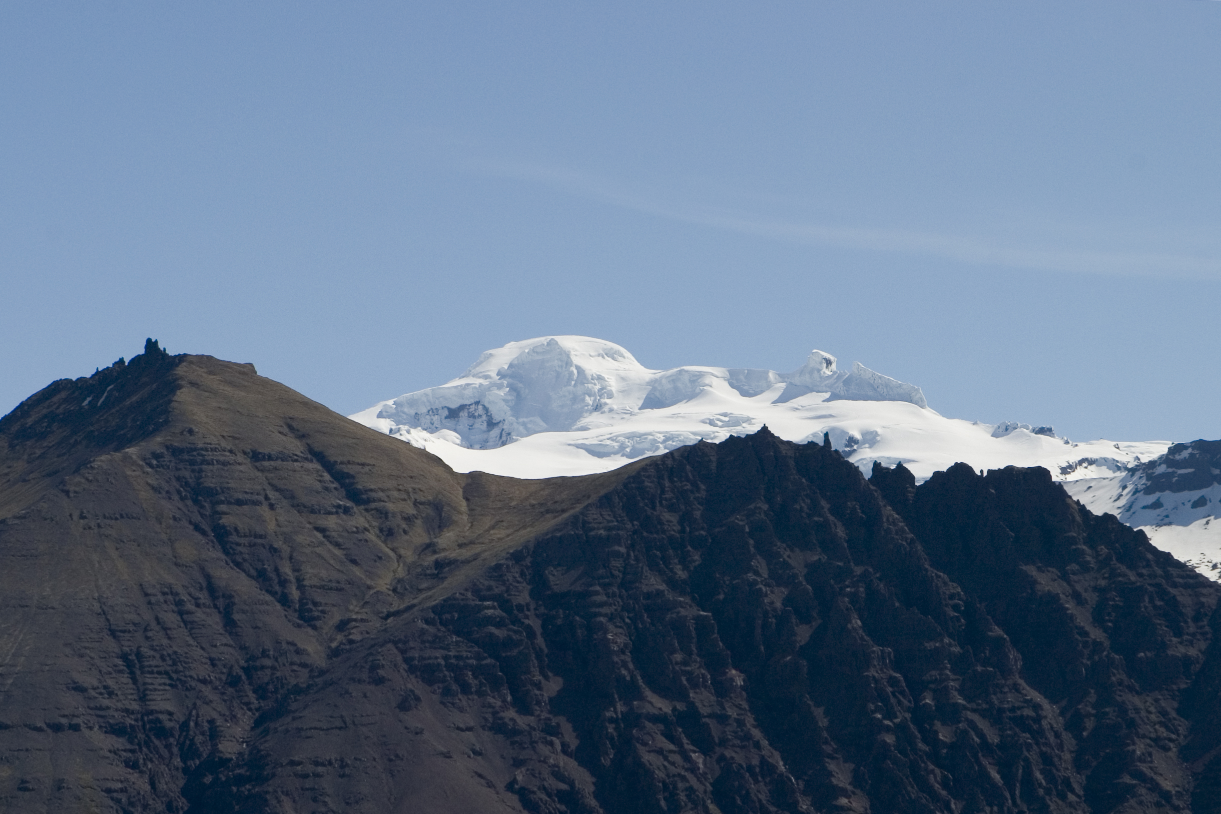
| photo | Öræfajökull - Mapillary (520905752282052).jpg | ||||||||
| elevation | 2109.6 m at Hvannadalshnúkur | ||||||||
| elevation_ref | |||||||||
| prominence | 2109.6 m at Hvannadalshnúkur | ||||||||
| location | Iceland | ||||||||
| coordinates | |||||||||
| type | Stratovolcano | ||||||||
| age | Pleistocene | ||||||||
| last_eruption | 3 August 1727 to May 1728 | ||||||||
| volume | 300 km3 | ||||||||
| volume_ref | |||||||||
| area | 400 km2 | ||||||||
| area_ref | |||||||||
| mapframe-zoom | 8 | ||||||||
| embedded | {{maplink | frame=yes | frame-align=center | frame-width=260 | frame-height=220 | frame-long=-16.59 | frame-lat=63.98 | zoom=9 | raw=,{"type": "FeatureCollection", "features": [{ |
| text | Topographic features of Öræfajökull. The approximate outline of the central volcano is outlined in red with caldera features in red shading. White/blue shading show glacier features relevant to [jökulhlaup risk. The peak Hvannadalshnúkur has a marker. More detail or zoom out to show other volcanoes in the Öræfi volcanic belt (brown shading) is available on clicking the image to enable mouse-over. |
| mapframe-zoom = 8 "type": "Feature" ,"properties": { "marker-symbol": "mountain", "marker-size": "small", "title": "Hvannadalshnúkur" }, "geometry": { "type": "Point", "coordinates": [-16.676903,64.013970] } } ]} ]
Öræfajökull (; 'Öræfi glacier' or 'wasteland glacier') is an ice-covered volcano in south-east Iceland. The largest active volcano and the highest peak in Iceland at 2110 m, it lies within the Vatnajökull National Park and is covered by part of the glacier.
The original Norse settlers named the volcano Knappafellsjǫkull (Old Norse: ; Modern Icelandic: Hnappafellsjökull ; 'knobs mountain glacier'). The current name, Öræfajökull, was eventually adopted after the 1362 eruption.
Description
Öræfajökull is located at the southern extremity of the Vatnajökull glacier and overlooking the Ring Road between Höfn and Vík. It is the largest active volcano in the country, and on the summit crater's north-western rim is Hvannadalshnúkur, the highest peak in Iceland at 2110 m.
Geographically, Öræfajökull as the glacier, is considered part of Vatnajökull, and the area covered by glacier is within the boundary of Vatnajökull National Park. There are a number of outlet glaciers in the ice cap within the area of the central volcano which clockwise from north are: Breiðamerkurjökull, Fjallsjökull, Hrútárjökull, Bræðrajökull, Kviarjökull, Hólárjökull, Stórhöfðajökull, Gljúfursárjökull, Rótarfjallsjökull (which has a western branch called Kotárjökull), Grænafjallsjökull, Falljökull, Virkisjökull, Svinafellsjökull and Skaftafellsjökull. While most of the outlet glaciers have reasonably clear catchments, not all do. Some of the icecap feeds directly into river catchments without a named glacier and this happens between the Hrútárjökull and Bræðrajökull, and the Virkisá river drains a number of glaciers between Rótarfjallsjökull and Svinafellsjökull (see map on this page).
The summit caldera of this stratovolcano is 3 x and the volcano is 20 km in diameter. It is the most southern of the volcanoes in the Öræfi volcanic belt (Öræfajökull volcanic belt), which is possibly an embryonic rift parallel and to the east of the Eastern volcanic zone. The presently active summit caldera may have a subcaldera within it. Eruptions in this area are most likely to result in jökulhlaups that will produce floods at the outlets of the Kviarjökull and Virkisá catchments as these overlap the present caldera. There is possibly an old caldera to the north of the current caldera and flank eruptions could produce jökulhlaup from other outlet glaciers. The topographical map on this page can be enlarged to show this detail.
Activity
Öræfajökull has erupted twice in historical times, in 1362 and 1728. These were explosive silicic eruptions with bulk tephra volumes of 0.1 – and jökulhlaups occurred. The deposits closer to the central volcano are rhyolytic but the more distal lava flows which can extend for 20 km from the caldera are alkali olivine basalt and both have been erupted in the Holocene.
1362 eruption
In 1362, Knappafellsjökull erupted explosively, ejecting 10 cubic kilometres of tephra, similar in scale to the 1991 eruption of Mount Pinatubo. The eruption sequence lasted for several months, being from a medium-potassium alkali rhyolite and has been assigned a VEI of 6 although dense-rock equivalent volume may be less than previous estimates at 1.2 km3. More than 40 years passed before people again settled the area, which became known as Öræfi. The name literally means 'an area without harbour,' but it took on a meaning of 'wasteland' in Icelandic, as the 1362 eruption had drastically altered the environment around the mountain. The volcano likewise took on the new name Öræfajökull.
1728 eruption
An eruption in August 1727–1728 was smaller than 1362, though floods are known to have caused three fatalities when the meltwater swept their farm away.

2017 activity
Increased earthquake activity in the form of small tremors ranging from a depth of 1.5–10 km beneath the summit crater, began in August 2017 according to the Icelandic Meteorological Office.
The Aviation Colour Code of the United States was raised to yellow on 17 November 2017, after the appearance of an ice cauldron inside the main crater and increased geothermal activity under the glacier.
2018 activity
The seismic and geothermal activity which began in August 2017 continued into 2018, but at reduced levels. On 4 May 2018, the Icelandic Meteorological Office lowered the Aviation Colour Code to green.
Landslide
In 2013 due to paraglacial slope failure, a large landslide affecting an area of 1.7 km2 occurred, that deposited debris on the volcano's Svínafellsjökull outlet glacier.
References
References
- [http://www.summitpost.org/hvannadalshnukur/152942 "Hvannadalshnukur"]. Summitpost.com. Retrieved 9 August 2013
- "Öræfajökull: Eruptive History".
- "History of Öræfajökull {{!".
- "National Land Survey of Iceland-Mapviewer (Kortasja-Landmælingar Íslands)".
- (2012). "Removing the ice cap of Öræfajökull central volcano, SE-Iceland: mapping and interpretation of bedrock topography, ice volumes, subglacial troughs and implications for hazards assessments". Jökull.
- (2019). "Catalogue of Icelandic Volcanoes:Öræfajökull".
- (2018). "Assessing impact to infrastructures due to tephra fallout from Öræfajökull volcano (Iceland) by using a scenario-based approach and a numerical model". Frontiers in Earth Science.
- "About Öræfajökull {{!}} Vatnajokull National Park".
- The wealthy district of Litlahérað was destroyed by [[jökulhlaup. flood]]s, [[pyroclastic flow]]s and [[volcanic ash
- Ravilious, Kate. (3 December 2017). "Terrawatch: the reawakening of Öræfajökull". The Guardian.
- "A new ice-cauldron in Öræfajökull volcano | News".
- "Öræfajökull: Activity Archives".
- (2022). "Paraglacial exposure and collapse of glacial sediment: The 2013 landslide onto Svínafellsjökull, southeast Iceland". Earth Surface Processes and Landforms.
This article was imported from Wikipedia and is available under the Creative Commons Attribution-ShareAlike 4.0 License. Content has been adapted to SurfDoc format. Original contributors can be found on the article history page.
Ask Mako anything about Öræfajökull — get instant answers, deeper analysis, and related topics.
Research with MakoFree with your Surf account
Create a free account to save articles, ask Mako questions, and organize your research.
Sign up freeThis content may have been generated or modified by AI. CloudSurf Software LLC is not responsible for the accuracy, completeness, or reliability of AI-generated content. Always verify important information from primary sources.
Report