From Surf Wiki (app.surf) — the open knowledge base
Kuril–Kamchatka Trench
Oceanic trench in the northwest Pacific

Oceanic trench in the northwest Pacific
The Kuril–Kamchatka Trench or Kuril Trench (, Kurilo-Kamchatskii Zhyolob) is an oceanic trench in the northwest Pacific Ocean. It lies off the southeast coast of Kamchatka and parallels the Kuril Island chain to meet the Japan Trench east of Hokkaido. It extends from a triple junction with the Ulakhan Fault and the Aleutian Trench near the Commander Islands, Russia, in the northeast, to the intersection with the Japan Trench in the southwest.
The trench formed as a result of the subduction zone, which formed in the late Cretaceous, that created the Kuril island arc as well as the Kamchatka volcanic arc. The Pacific plate is being subducted beneath the Okhotsk plate along the trench, resulting in intense volcanism.
The maximum depth of the trench is reported in peer-reviewed academic papers as 9,600 meters.
History
The trench was first discovered during an oceanographic and hydrographic survey by the USS Tuscarora. The ship had detected a depth of 4655 fathoms.
Tectonics
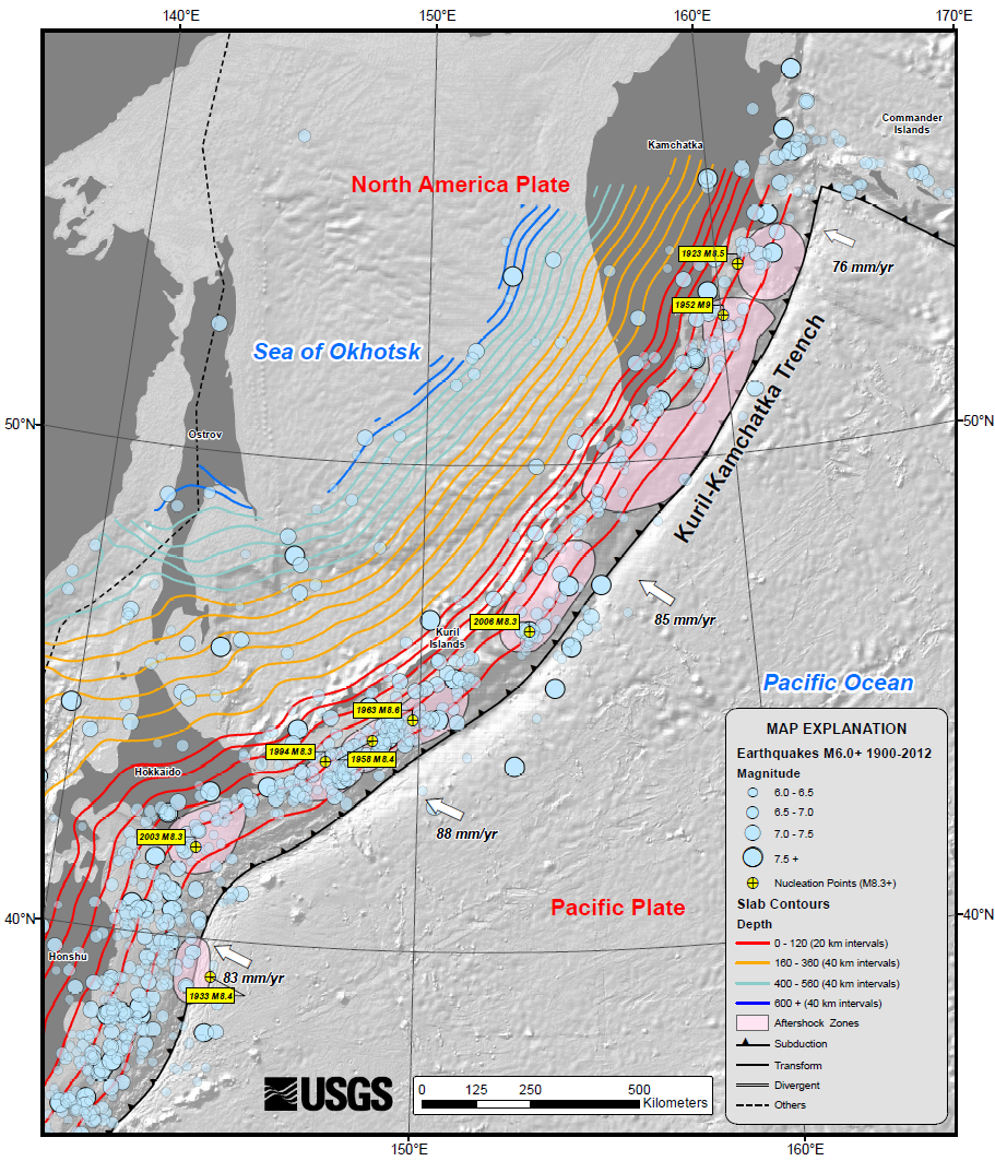
At the Kuril–Kamchatka Trench, the Pacific plate is subducting beneath the Okhotsk plate, a minor tectonic plate formerly considered to be part of the North American plate. The convergence rate ranges from ≈75 mm/yr in the north to ≈83 mm/yr at the southern end. Obliquity of convergence increases to the south, where the transpressional stress is partitioned into trench-normal thrust earthquakes and trench-parallel strike-slip earthquakes. This partitioning results in westward translation of the Kurile forearc relative to the North American plate.
Associated seismicity
Major earthquakes associated with the subduction zone:
| Date | Location | Magnitude |
|---|---|---|
| 3 February 1923 | Kamchatka, Russia | |
| 13 April 1923 | Kamchatka, Russia | |
| 2 March 1933 | Sanriku-oki, Japan | |
| 4 November 1952 | Kamchatka, Russia | |
| 6 November 1958 | Kuril Islands, Russia | |
| 13 October 1963 | Kuril Islands, Russia | |
| 4 October 1994 | Kuril Islands, Russia | |
| 25 September 2003 | Hokkaido, Japan | |
| 15 November 2006 | Kuril Islands, Russia | |
| 24 May 2013 | Sea of Okhotsk | |
| 18 July 2017 | Kamchatka, Russia | |
| 25 March 2020 | Kamchatka, Russia | |
| 29 July 2025 | Kamchatka, Russia |
References
References
- Kamenev, Gennady M.. (10 February 2022). "Macrofauna and Nematode Abundance in the Abyssal and Hadal Zones of Interconnected Deep-Sea Ecosystems in the Kuril Basin (Sea of Okhotsk) and the Kuril-Kamchatka Trench (Pacific Ocean)".
- (2020). "Will the "top five" deepest trenches lose one of their members?". Elsevier BV.
- ThebergeAuthor, Albert E.. (2009-03-24). "Thirty Years of Discovering the Mariana Trench".
- Rhea, S., et al., 2010, [https://pubs.usgs.gov/of/2010/1083/c/ Seismicity of the Earth 1900–2007, Kuril-Kamchatka arc and vicinity], U.S. Geological Survey Open-File Report 2010-1083-C, 1 map sheet, scale 1:5,000,000 accessed 25 October 2022
- (2013-05-25). "M8.3 – Sea of Okhotsk". United States Geological Survey.
This article was imported from Wikipedia and is available under the Creative Commons Attribution-ShareAlike 4.0 License. Content has been adapted to SurfDoc format. Original contributors can be found on the article history page.
Ask Mako anything about Kuril–Kamchatka Trench — get instant answers, deeper analysis, and related topics.
Research with MakoFree with your Surf account
Create a free account to save articles, ask Mako questions, and organize your research.
Sign up freeThis content may have been generated or modified by AI. CloudSurf Software LLC is not responsible for the accuracy, completeness, or reliability of AI-generated content. Always verify important information from primary sources.
Report