From Surf Wiki (app.surf) — the open knowledge base
India–Bangladesh enclaves
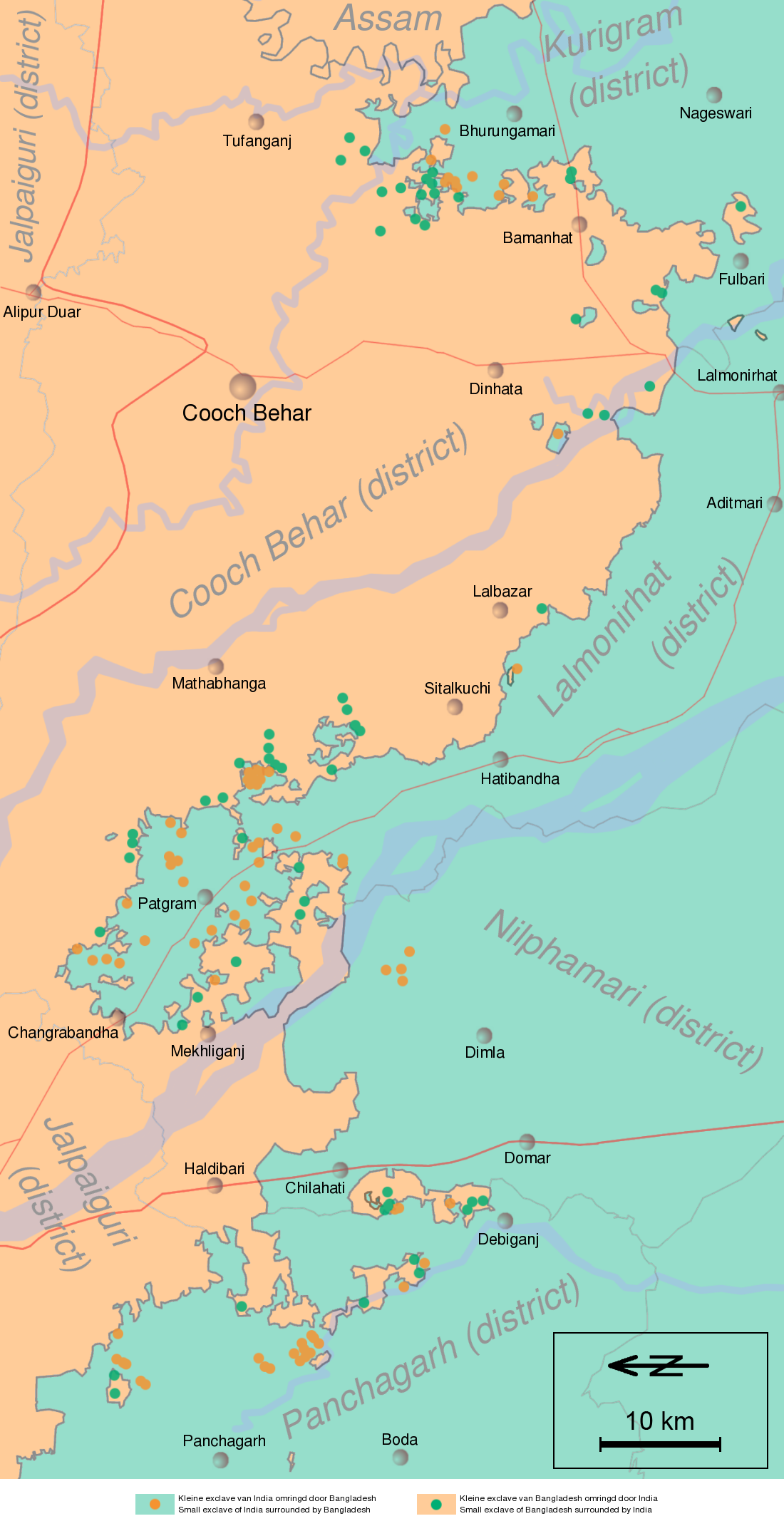
Enclaves along the Bangladesh–India border
Enclaves along the Bangladesh–India border
The India–Bangladesh enclaves, also known as the Chiṭmahals ( chiṭmôhôl) and sometimes called Pasha enclaves, were the enclaves along the Bangladesh–India border, in Bangladesh and the Indian states of West Bengal, Tripura, Assam and Meghalaya. The main body of Bangladesh contained 102 Indian enclaves, which in turn contained 21 Bangladeshi counter-enclaves, one of which contained Dahala Khagrabari, an Indian counter-counter-enclave, the world's only third-order enclave when it existed. The Indian mainland contained 71 Bangladeshi enclaves, which in turn contained 3 Indian counter-enclaves. A joint census in 2010 found 51,549 people who were residing in these enclaves: 37,334 in Indian enclaves within Bangladesh and 14,215 in Bangladeshi enclaves within India.
The Prime Ministers of India and Bangladesh signed the Land Boundary Agreement in 1974 to exchange enclaves and simplify their international border. A revised version of the agreement was adopted by the two countries on 7 May 2015, when the Parliament of India passed the 100th Amendment to the Constitution of India. Under this agreement, which was ratified on 6 June 2015, India received 51 Bangladeshi enclaves (covering 7,110 acres) in the Indian mainland, while Bangladesh received 111 Indian enclaves (covering 17,160 acres) in the Bangladeshi mainland. The enclave residents were allowed to either continue residing at their present location or move to the country of their choice. The exchange of enclaves was to be implemented in phases between 31 July 2015 and 30 June 2016. The enclaves were exchanged at midnight on 31 July 2015 and the transfer of enclave residents was completed on 30 November 2015. After the Land Boundary Agreement, India lost around 40 km2 to Bangladesh.
Since the exchange of territory took place, the only remaining enclave is Dahagram–Angarpota, an exclave of Bangladesh.
History
According to a popular legend, the enclaves were used as stakes in card or chess games centuries ago between two regional kings, the Raja of Koch Bihar and the Maharaja of Rangpur. As far as historical records are concerned, the little territories were apparently the result of a confused outcome of a 1713 treaty between the Kingdom of Koch Bihar and the Mughal Empire. Possibly, the Kingdom and the Mughals ended a war without determining a boundary for what territories had been gained or lost.
After the partition of India in 1947, Rangpur was joined to East Pakistan. Cooch Behar State, with its exclaves and holes, was a native state, whose Raja had the option of joining either India or Pakistan. Cooch Behar district was merged in 1949 with India. The desire to "de-enclave" most of the enclaves was manifested in a 1958 agreement between Jawaharlal Nehru and Feroz Khan Noon, the respective Prime Ministers, for an exchange between India and Pakistan without considering loss or gain of territory. But the matter then worked into a Supreme Court case in India, and the Supreme Court ruled that a constitutional amendment was required to transfer the land, so the ninth amendment was introduced to facilitate the implementation of the agreement. The amendment could not be passed because of objections to the transfer of the southern Berubari enclave. Because of India's deteriorated relations with Pakistan, the issue remained unsolved. Negotiations restarted after East Pakistan became independent as Bangladesh in 1971 following the Bangladesh Liberation War.
Agreement

The Land Boundary Agreement was signed on 16 May 1974 between Indira Gandhi and Sheikh Mujibur Rahman which provided for the exchange of enclaves and the surrender of adverse possessions. Under the agreement, India retained the Berubari Union No. 12 enclave while Bangladesh retained the Dahagram-Angorpota exclaves with India providing access to it by giving a 178 × corridor, called the Tin Bigha Corridor. Bangladesh quickly ratified the agreement in 1974 but India failed to do so. The issue of the undemarcated land boundary of approximately 6.1 km in three sectors — Daikhata-56 in West Bengal, Muhuri River-Belonia in Tripura and Lathitila-Dumabari in Assam — also remained unsolved. The Tin Bigha Corridor was leased to Bangladesh in 1992 amid local opposition.
The list of enclaves was prepared in 1997 by the two countries. Two Joint Boundary Working Groups were formed to work out the details of enclaves in 2001. A joint census was carried out in May 2007. In September 2011, India signed the Additional Protocol for the 1974 Land Boundary Agreement with Bangladesh. Both nations announced an intention to swap 162 enclaves, giving residents a choice of nationality.
Under the agreement, India received 51 of the 71 Bangladeshi enclaves (from 51 to 54 of the 74 chhits) that were inside India proper (7,110.2 acres), while Bangladesh received 95 to 101 of the 103 Indian enclaves (111 out of 119 chhits) that were inside Bangladesh proper (17,160.63 acres). The people living in these enclaves without a nationality were allowed to choose their nationality.
The Constitution (119th Amendment) Bill, 2013 was introduced in the Rajya Sabha, the upper house of the Parliament of India, on 18 December 2013. Nationalist groups in Assam strongly opposed the bill, which would cause India to lose 40 km2 (10,000 acres) of land, but Indian Prime Minister Narendra Modi supported it because it would make the border with Bangladesh easier to manage. The parliament panel, Standing Committee on External Affairs, approved the bill in November 2014. The Rajya Sabha approved the constitutional amendment on 6 May 2015, and the Lok Sabha approved it the following day. President of India Pranab Mukherjee gave his assent to the Act on 28 May 2015.
On 6 June 2015, Modi ratified the agreement during his visit to the Bangladesh capital Dhaka. In the presence of Modi and Bangladeshi Prime Minister Sheikh Hasina, the foreign secretaries of the two countries signed the instruments of the land exchange. The exchange of enclaves and land parcels in adverse possession, and the boundary demarcation, was implemented in phases between 31 July 2015 and 30 June 2016. The enclaves were to be exchanged at midnight on 31 July 2015 and the boundary demarcation was to be completed by 30 June 2016 by Survey Departments of the respective countries. The transfer of enclave residents was expected to be completed by 30 November 2015.
Indian and Bangladeshi officials conducted a field survey of enclave residents between 6 July 2015 and 16 July 2015. Seventy-five teams, made up of one Indian and one Bangladeshi member each, were tasked with conducting the enumeration. Twenty-five teams surveyed the Bangladeshi enclaves which would be transferred to India, while 50 worked on the Indian enclaves that would be transferred to Bangladesh. As the enclave residents were allowed to choose citizenship of either nation, by 13 July 2015, 100 families residing in the Indian enclaves applied for Indian citizenship, while none of the residents of the Bangladeshi enclaves chose to go to Bangladesh. New citizenship, if chosen, took effect from 1 August 2015. Nearly 14,000 people living in the former Bangladeshi enclaves became Indian citizens, while about 36,000 people living in the former Indian enclaves became Bangladeshi citizens. Some 1,000 people in the former Indian enclaves chose Indian citizenship and were to be relocated to India by December 2015.
Notable enclaves
Bangladesh
Dahagram–Angarpota: The largest Bangladeshi composite enclave (combining the first- and third-largest Bangladeshi chhits by area), administered as part of Patgram Upazila in Lalmonirhat Zila, lies within the Indian province of West Bengal. It is separated from the contiguous area of Bangladesh at its closest point by 178 m. The enclave has an area of 25.95 km2 with a resident population of 20,000 people. The enclave lacks basic facilities. The lone health complex remains virtually useless because of lack of power supply, as India refused to allow Bangladesh to run power lines to the enclave. After the exchange of enclaves in July 2015, Bangladesh retained it as an exclave.
The Tin Bigha Corridor, a strip of Indian territory 85 m wide running from the Dahagram–Angarpota composite enclave to the Bangladeshi mainland at their nearest approach, was leased by India in perpetuity to Bangladesh for access to the enclave. It is available for use by the residents of Dahagram–Angarpota.
India
Dasiar Chhara, the fourth largest Indian chhit by area, was the largest stand-alone Indian enclave (i.e., not a composite of adjoining chhits). It lay 3 km from the main part of India and had an area of 6.65 km2.
Dahala Khagrabari, enclave #51, was the world's only third-order enclave, being a piece of India within Bangladesh, within India, within Bangladesh. It was the site of a jute field, owned by a Bangladeshi farmer living in the Bangladeshi second-order enclave surrounding Dahala Khagrabari. As part of the 2015 border agreement, India ceded it to Bangladesh.
List of former enclaves and exclaves
Schematic overview:
| 1 counter-counter enclave of India (0.007 km2) |
|---|
|} |} |}
| 7 counter-enclaves of India (0.17 km2) |
|---|
|} |} |}
Some individual enclaves were composed of several administrative units (chhits and/or mauzas). These administrative units must be differentiated from the enclave as a whole. "This is particularly important for the Cooch Behar enclaves, where the several administrative units which together form some of the larger enclaves are commonly, but wrongly, termed enclaves themselves, or where one component unit commonly lends its name to the whole enclave. ... [T]he official Indo–Bangladesh Boundary Commission figure of 111 Indian and 51 Bangladeshi exchangeable enclaves would appear to count only individual mauzas, even when these consisted of more than one enclave." There is not a one-to-one relationship between enclaves, chhits and mauzas.
All of the information shown in the following two tables has been assembled from Brendan R. Whyte.
Bangladesh
In order to distinguish chhits having the same names, serial numbers established by Banerjee (1966) are shown in parentheses, as (#). The Bangladesh series is separate from the India series.
With 4 exceptions (Chhat Tilai, Baikunthapur Teldhar (#3, #4, #5)), the first-order enclaves, including the 3 composite enclaves, lay entirely within the Cooch Behar District of West Bengal state, India. All 21 counter-enclaves lay within the Rangpur Division of Bangladesh. The Bangladeshi enclaves had an estimated population of 14,215 in 2015.
| Bangladeshi chhits within Indian territory | Area (km2) | Area (mi2) | Notes | |
|---|---|---|---|---|
| Dahagram-Angarpota | 18.684 | 18.684 km2 | Largest composite exclave of Bangladesh within India, comprises the contiguous Dahagram and Angarpota chhits. This exclave continues to exist in spite of the 2015 land swap. | |
| Dahagram❋ | 15.690 | 15.690 km2 | Largest chhit of Bangladesh, part of the Dahagram-Angarpota composite exclave within India. | |
| Nalgram | 7.705 | 7.705 km2 | Composite exclave of Bangladesh within India, comprises the contiguous Falnapur and Nalgram (#52) chhits. | |
| Nalgram (#52)❋ | 5.655 | 5.655 km2 | Part of the Nalgram composite exclave within India (area includes 2 other smaller chhits, each itself an exclave and true enclave, each also named Nalgram (#53, #54)). Surrounded the Indian counter-enclave, Nalgram Chhit (#111). | |
| Nalgram (#53) | see #52 | see #52 | First-order enclave within India, area combined with that shown for the larger Nalgram (#52). | |
| Nalgram (#54) | see #52 | see #52 | First-order enclave within India, area combined with that shown for the larger Nalgram (#52). | |
| Angarpota❋ | 2.994 | 2.994 km2 | Part of the Dahagram-Angarpota composite exclave within India. | |
| Dakshin Masaldanga | Composite exclave of Bangladesh within India, comprises the contiguous Kachua and Dakshin Masaldanga (#74) chhits. | |||
| Poaturkuthi | 2.387 | 2.387 km2 | First-order enclave within India. | |
| Batrigach (#59) | 2.337 | 2.337 km2 | First-order enclave within India (area includes the smaller Batrigach (#60), itself an exclave and true enclave). Surrounded the Indian counter-enclave, Madnakura Chhit in Bhoti Nath Batrigach. | |
| Batrigach (#60) | see #59 | see #59 | First-order enclave within India, area combined with that shown for the larger Batrigach (#59). | |
| Dakshin Masaldanga (#74)❋ | 2.312 | 2.312 km2 | Part of the Dakshin Masaldanga composite exclave (along with Kachua chhit) within India; area included 6 other smaller chhits, each also named Dakshin Masaldanga (#73, 75, 76, 77, 78 & 90), each itself an exclave and true enclave. | |
| Dakshin Masaldanga (#73) | see #74 | see #74 | First-order enclave within India, area combined with that shown for the larger Dakshin Masaldanga (#74). | |
| Dakshin Masaldanga (#75) | see #74 | see #74 | First-order enclave within India, area combined with that shown for the larger Dakshin Masaldanga (#74). | |
| Dakshin Masaldanga (#76) | see #74 | see #74 | First-order enclave within India, area combined with that shown for the larger Dakshin Masaldanga (#74). | |
| Dakshin Masaldanga (#77) | see #74 | see #74 | First-order enclave within India, area combined with that shown for the larger Dakshin Masaldanga (#74). | |
| Dakshin Masaldanga (#78) | see #74 | see #74 | First-order enclave within India, area combined with that shown for the larger Dakshin Masaldanga (#74). | |
| Dakshin Masaldanga (#90) | see #74 | see #74 | First-order enclave within India, area combined with that shown for the larger Dakshin Masaldanga (#74). | |
| Falnapur❋ | 2.050 | 2.050 km2 | Part of the Nalgram composite exclave within India. | |
| Sibprasad Mustafi (#67) | 1.510 | 1.510 km2 | First-order enclave within India (area includes the smaller Sibprasad Mustafi (#68), itself an exclave and true enclave). | |
| Sibprasad Mustafi (#68) | see #67 | see #67 | First-order enclave within India, area combined with that shown for the larger Sibprasad Mustafi (#67). | |
| Chhit Kuchlibari | 1.500 | 1.500 km2 | First-order enclave within India. | |
| Bala Pukhari | 1.342 | 1.342 km2 | First-order enclave within India. | |
| Karala (#63) | 1.092 | 1.092 km2 | First-order enclave within India (area includes 2 other smaller chhits, each itself an exclave and true enclave, each also named Karala (#64, #65)). | |
| Karala (#64) | see #63 | see #63 | First-order enclave within India, area combined with that shown for the larger Karala (#63). | |
| Karala (#65) | see #63 | see #63 | First-order enclave within India, area combined with that shown for the larger Karala (#63). | |
| Kismat Batrigach | 0.850 | 0.850 km2 | First-order enclave within India. | |
| Dhabalsati Mirgipur | 0.704 | 0.704 km2 | First-order enclave within India. | |
| Upan Chowki Bhajni, 111 | 0.685 | 0.685 km2 | Counter-exclave that was surrounded by and shared borders with two contiguous Indian chhits, Balapara Khagrabari (#42) and Kothajni (#43) (both within the composite exclave named "Balapara Khagrabari" in the Panchagarh District of Bangladesh). | |
| Purba Masaldanga (#87) | 0.623 | 0.623 km2 | First-order enclave within India (area includes the smaller Purba Masaldanga (#86), itself an exclave and true enclave). A map from the 1930s and a 1940 source imply that Purba Masaldanga (#86) and (#87) formed a single enclave. However, topographic mapping and other sources suggest two enclaves, as listed here, but if joined, they were connected across the narrowest gap separating them, along a beel (marshy former river course). | |
| Purba Masaldanga (#86) | see #87 | see #87 | First-order enclave within India, area combined with that shown for the larger Purba Masaldanga (#87). | |
| Paschim Bakalir Chhara | 0.615 | 0.615 km2 | First-order enclave within India. | |
| Madhya Masaldanga | 0.553 | 0.553 km2 | First-order enclave within India. Surrounded the Indian counter-enclave, Chhit Seoruguri. | |
| Mahishmari | 0.497 | 0.497 km2 | First-order enclave within India. | |
| Kachua❋ | 0.485 | 0.485 km2 | Part of the Dakshin Masaldanga composite exclave (along with Dakshin Masaldanga #74) within India. | |
| Upan Chowki Bhajni, 110 | 0.449 | 0.449 km2 | Counter-enclave surrounded by an Indian exclave, Dahala Khagrabari (#47), located within the Panchagarh District of Bangladesh. It surrounds the only counter-counter-enclave in the world, Dahala Khagrabari (#51). | |
| Chhit Panbari | 0.439 | 0.439 km2 | First-order enclave within India. | |
| Jote Nijjama | 0.354 | 0.354 km2 | First-order enclave within India; it may possibly have formed an international quadripoint (one point in common with four different areas) of Bangladesh and India: two parts of Patgram thana (main part and the Jote Nijjama enclave itself) in Lalmonirhat District and two parts of Mekhliganj thana in Mekhliganj subdivision, Cooch Behar District, India. | |
| Chhat Tilai | 0.330 | 0.330 km2 | First-order enclave within India, straddling the border of Cooch Behar District (West Bengal) and Dhubri District (Assam). | |
| Upan Chowki Bhajni, 22 | 0.292 | 0.292 km2 | Counter-enclave surrounded by an Indian exclave, Dahala Khagrabari (#47), located within the Panchagarh District of Bangladesh. | |
| Chhit Land of Jagatber No. 3 | 0.283 | 0.283 km2 | First-order enclave within India. | |
| Chhit Dhabalsati | 0.269 | 0.269 km2 | First-order enclave within India. | |
| Dhabalsati (#32) | 0.245 | 0.245 km2 | First-order enclave within India. | |
| Baikunthapur Teldhar (#4) | 0.210 | 0.210 km2 | First-order enclave within Jalpaiguri District, West Bengal, India (area includes 2 other smaller chhits, each itself an exclave and true enclave, each also named Baikunthapur Teldhar (#3, #5)). | |
| Baikunthapur Teldhar (#3) | see #4 | see #4 | First-order enclave within Jalpaiguri District, West Bengal, India (area combined with that shown for the larger Baikunthapur Teldhar (#4)). | |
| Baikunthapur Teldhar (#5) | see #4 | see #4 | First-order enclave within Jalpaiguri District, West Bengal, India (area combined with that shown for the larger Baikunthapur Teldhar (#4)). | |
| Chhit Nalgram (#55) | 0.200 | 0.200 km2 | First-order enclave within India (area includes Chhit Nalgram (#56), itself an exclave and true enclave). | |
| Chhit Nalgram (#56) | see #55 | see #55 | First-order enclave within India, area combined with that shown for Chhit Nalgram (#55). | |
| Uttar Bansjani | 0.191 | 0.191 km2 | First-order enclave within India. | |
| Chhit Bhandardaha | 0.162 | 0.162 km2 | First-order enclave within India. | |
| Upan Chowki Bhajni, 113 | 0.148 | 0.148 km2 | Counter-exclave surrounded by and sharing a border with two contiguous Indian exclaves, Balapara Khagrabari (#42) and Kothajni (#43) (both within the composite exclave named "Balapara Khagrabari" in the Panchagarh District of Bangladesh). | |
| Purba Chhit Masaldanga (#84) | 0.142 | 0.142 km2 | First-order enclave within India (area includes the smaller Purba Chhit Masaldanga (#83), itself an exclave and true enclave). | |
| Purba Chhit Masaldanga (#83) | see #84 | see #84 | First-order enclave within India, area combined with that shown for the larger Purba Chhit Masaldanga (#84). | |
| Bara Saradubi | 0.141 | 0.141 km2 | First-order enclave within India; formed an international quadripoint (one point in common with four different areas) of Bangladesh and India: two parts of Hatibandha thana (main part and the Bara Saradubi enclave itself) in Lalmonirhat District and two parts of Sitalkuchi thana in Mathabhanga subdivision, Cooch Behar District, India. | |
| Chandrakhan | 0.140 | 0.140 km2 | Counter-enclave surrounded by an Indian true enclave/exclave, Dasiar Chhara (#117), located within the Kurigram District of Bangladesh. | |
| Madhya Bakalir Chhara | 0.132 | 0.132 km2 | First-order enclave within India. | |
| Chhit Land of Jagatber No. 1 | 0.124 | 0.124 km2 | First-order enclave within India. | |
| Chhit Kokoabari | 0.1193 | 0.1193 km2 | First-order enclave within India. | |
| Paschim Masaldanga (#79) | 0.1193 | 0.1193 km2 | First-order enclave within India (area includes Paschim Masaldanga (#80), itself an exclave and true enclave). | |
| Paschim Masaldanga (#80) | see #79 | see #79 | First-order enclave within India, area combined with that shown for Paschim Masaldanga (#79). | |
| Uttar Masaldanga | 0.1104 | 0.1104 km2 | First-order enclave within India. | |
| Chhit Land of Jagatber No. 2 | 0.1096 | 0.1096 km2 | First-order enclave within India. | |
| Chhit Land of Dhabalguri No. 2 | 0.1086 | 0.1086 km2 | First-order enclave within India. | |
| Bansua Khamar Gitaldaha | 0.0993 | 0.0993 km2 | First-order enclave within India. | |
| Uttar Dhaldanga (#93) | 0.0966 | 0.0966 km2 | First-order enclave within India (area includes 2 other smaller chhits, each itself an exclave and true enclave, each also named Uttar Dhaldanga (#92, #94)). | |
| Uttar Dhaldanga (#92) | see #93 | see #93 | First-order enclave within India, area combined with that shown for the larger Uttar Dhaldanga (#93). | |
| Uttar Dhaldanga (#94) | see #93 | see #93 | First-order enclave within India, area combined with that shown for the larger Uttar Dhaldanga (#93). | |
| Chhit Dhabalguri | 0.0903 | 0.0903 km2 | First-order enclave within India. | |
| Durgapur | 0.0848 | 0.0848 km2 | First-order enclave within India. | |
| Nazirganj (#10) | 0.0799 † | 0.0799 km2 † | Counter-enclave surrounded by an Indian exclave, Bewladanga (#39), located within the Panchagarh District of Bangladesh. | |
| Teldhar (#1) | 0.0586 | 0.0586 km2 | Counter-enclave surrounded by an Indian true enclave/exclave, Garati (#1), located within the Panchagarh District of Bangladesh (area includes the smaller Teldhar (#2), itself an exclave and true enclave). | |
| Teldhar (#2) | see #1 | see #1 | Counter-enclave surrounded by an Indian true enclave/exclave, Garati (#1), located within the Panchagarh District of Bangladesh, area combined with that shown for the larger Teldhar (#1). | |
| Upan Chowki Bhajni, 112 | 0.0571 | 0.0571 km2 | Counter-enclave surrounded by an Indian exclave, Kothajni (#43), located within the Panchagarh District of Bangladesh. | |
| Chhit Land of Dhabalguri No. 1 | 0.0565 | 0.0565 km2 | First-order enclave within India. | |
| Dhabalguri | 0.0506 | 0.0506 km2 | First-order enclave within India. | |
| Purba Bakalir Chhara | 0.0495 | 0.0495 km2 | First-order enclave within India. | |
| Madhya Chhit Masaldanga | 0.0480 | 0.0480 km2 | First-order enclave within India. | |
| Jongra | 0.0334 | 0.0334 km2 | Counter-enclave surrounded by an Indian true enclave/exclave, Banskata (#93), located within the Lalmonirhat District of Bangladesh. | |
| Paschim Chhit Masaldanga | 0.0308 | 0.0308 km2 | First-order enclave within India. | |
| Debi Doba | 0.0302 | 0.0302 km2 | Counter-enclave surrounded by an Indian exclave, Dahala Khagrabari (#47), located within the Panchagarh District of Bangladesh. | |
| Nazirganj −29 | 0.0265 | 0.0265 km2 | Counter-enclave surrounded by an Indian true enclave/exclave, Nazirganj (#27), located within the Panchagarh District of Bangladesh. | |
| Debottar Saldanga | 0.0247 | 0.0247 km2 | Counter-enclave surrounded by an Indian exclave, Bewladanga (#39), located within the Panchagarh District of Bangladesh. | |
| Chhit Land of Dhabalguri No. 4 | 0.0184 | 0.0184 km2 | First-order enclave within India. | |
| Chhit Land of Dhabalguri No. 5 | 0.0167 | 0.0167 km2 | First-order enclave within India. | |
| Bamandal | 0.0089 | 0.0089 km2 | First-order enclave within India. | |
| Chhit Land of Kuchlibari | 0.0074 | 0.0074 km2 | First-order enclave within India. | |
| Upan Chowki Bhajni, 99 | 0.0071 | 0.0071 km2 | Counter-enclave surrounded by an Indian exclave, Kothajni (#43), located within the Panchagarh District of Bangladesh. | |
| Dhabalsati (#33) | 0.0065 | 0.0065 km2 | Counter-enclave surrounded by an Indian exclave, Bara Khangir (#66), located within the Lalmonirhat District of Bangladesh. | |
| Nazirganj (#8) | 0.0062 † | 0.0062 km2 † | Counter-enclave surrounded by an Indian exclave, Shalbari (#35), located within the Panchagarh District of Bangladesh. | |
| Upan Chowki Bhajni, 13 | 0.0054 | 0.0054 km2 | Counter-enclave surrounded by an Indian exclave, Kothajni (#43), located within the Panchagarh District of Bangladesh. | |
| Chhit Land of Dhabalguri No. 3 | 0.0054 | 0.0054 km2 | First-order enclave within India. | |
| Amjhol | 0.0051 | 0.0051 km2 | First-order enclave within India. | |
| Chhit Land of Panbari No. 2 | 0.0046 | 0.0046 km2 | First-order enclave within India. | |
| Nazirganj −30 | 0.0046 | 0.0046 km2 | Counter-enclave surrounded by an Indian true enclave/exclave, Nazirganj (#19), located within the Panchagarh District of Bangladesh. | |
| Srirampur | 0.0042 | 0.0042 km2 | First-order enclave within India. | |
| Upan Chowki Bhajni, 15 | 0.0041 | 0.0041 km2 | Counter-enclave surrounded by an Indian exclave, Dahala Khagrabari (#47), located within the Panchagarh District of Bangladesh. | |
| Nazirganj (#9) | 0.00291 † | 0.00291 km2 † | Counter-enclave surrounded by an Indian exclave, Shalbari (#35), located within the Panchagarh District of Bangladesh. | |
| Upan Chowki Bhajni, 24 | 0.00287 | 0.00287 km2 | Smallest known chhit of Bangladesh, a counter-enclave surrounded by an Indian exclave, Kothajni (#43), located within the Panchagarh District of Bangladesh. |
:❋ This chhit was part of a composite enclave and by itself was neither an enclave nor an exclave. :† Stated size may not be exact.
India
The 102 first-order enclaves (including the 6 composite enclaves) and the 1 counter-counter enclave lay within the Rangpur Division of Bangladesh. The 3 counter-enclaves lay within the Cooch Behar District of West Bengal state, India. In order to distinguish chhits having the same names, serial numbers established by Banerjee (1966) are shown in parentheses, as (#). The India series is separate from the Bangladesh series. There were 37,334 people living in the Indian enclaves in 2015.
| Indian chhits within Bangladeshi territory | Area (km2) | Area (mi2) | Notes | |
|---|---|---|---|---|
| Balapara Khagrabari | 25.952 | 25.952 km2 | Composite exclave of India, bordering the Panchagarh and Nilphamari Districts, Bangladesh, comprised the contiguous Dahala Khagrabari (#47), Kothajni (#43) and Balapara Khagrabari (#42) chhits (area includes 6 other smaller chhits, each itself an exclave and true enclave: 3 also named Dahala Khagrabari (#48, #49, #50) and 3 also named Kothajni (#44, #45, #46)). | |
| Shalbari | 14.091 | 14.091 km2 | Composite exclave of India within the Panchagarh District of Bangladesh, comprised the contiguous Shalbari (#35), Bewladanga (#39), Kajal Dighi, Daikhata Chhat, Nataoka (#37) and Nataoka (#38) chhits. | |
| Dahala Khagrabari (#47)❋ | 10.717 | 10.717 km2 | Largest chhit of India, part of Balapara Khagrabari composite exclave within the Panchagarh District of Bangladesh (area includes 3 other smaller chhits, each itself an exclave and true enclave, each also named Dahala Khagrabari (#48, #49, #50)). | |
| Dahala Khagrabari (#48) | see #47 | see #47 | First-order enclave within the Panchagarh District of Bangladesh, area combined with that shown for the larger Dahala Khagrabari (#47). | |
| Dahala Khagrabari (#49) | see #47 | see #47 | First-order enclave within the Panchagarh District of Bangladesh, area combined with that shown for the larger Dahala Khagrabari (#47). | |
| Dahala Khagrabari (#50) | see #47 | see #47 | First-order enclave within the Panchagarh District of Bangladesh, area combined with that shown for the larger Dahala Khagrabari (#47). | |
| Kothajni (#43)❋ | 8.143 | 8.143 km2 | Part of Balapara Khagrabari composite exclave, bordering the Panchagarh and Nilphamari Districts, Bangladesh (area includes 3 other smaller chhits, each itself an exclave and true enclave, each also named Kothajni (#44, #45, #46)). | |
| Kothajni (#44) | see #43 | see #43 | First-order enclave within the Panchagarh District of Bangladesh, area combined with that shown for the larger Kothajni (#43). | |
| Kothajni (#45) | see #43 | see #43 | First-order enclave within the Panchagarh District of Bangladesh, area combined with that shown for the larger Kothajni (#43). | |
| Kothajni (#46) | see #43 | see #43 | First-order exclave bordering the Panchagarh and Nilphamari Districts, Bangladesh, area combined with that shown for the larger Kothajni (#43). | |
| Balapara Khagrabari (#42)❋ | 7.092 | 7.092 km2 | Part of Balapara Khagrabari composite exclave, bordering the Panchagarh District and Nilphamari Districts, Bangladesh. | |
| Dasiar Chhara | 6.651 | 6.651 km2 | First-order enclave within the Kurigram District of Bangladesh. | |
| Shalbari (#35)❋ | 4.811 | 4.811 km2 | Part of Shalbari composite exclave within the Panchagarh District of Bangladesh. | |
| Garati (#1) | 3.920 | 3.920 km2 | First-order enclave within the Panchagarh District of Bangladesh. | |
| Bewladanga (#39)❋ | 3.479 | 3.479 km2 | Part of Shalbari composite exclave within the Panchagarh District of Bangladesh. | |
| Kajal Dighi❋ | 3.122 | 3.122 km2 | Part of Shalbari composite exclave within the Panchagarh District of Bangladesh. | |
| Daikhata Chhat❋ | 2.020 | 2.020 km2 | Part of Shalbari composite exclave within the Panchagarh District of Bangladesh. | |
| Najirgonja (#33) | 1.758 | 1.758 km2 | First-order enclave within the Panchagarh District of Bangladesh. | |
| Banskata (#93) | 1.675 | 1.675 km2 | First-order enclave within the Lalmonirhat District of Bangladesh. | |
| Kamat Changrabandha | 1.626 | 1.626 km2 | Composite exclave of India within the Lalmonirhat District of Bangladesh, comprised the contiguous Bhotbari (#74), Panisala (#77) and Kamat Changrabandha (#75, #76) chhits. | |
| Banskata (#97) | 1.275 | 1.275 km2 | First-order enclave within the Lalmonirhat District of Bangladesh. | |
| Lotamari (#83) | 1.147 | 1.147 km2 | First-order enclave within the Lalmonirhat District of Bangladesh. | |
| Kharkharia | 0.904 | 0.904 km2 | Composite exclave of India within the Lalmonirhat District of Bangladesh, comprised the contiguous Lotamari (#73), Kharkharia (#71) and Kharkharia (#72) chhits. | |
| Bans Pachai | 0.879 | 0.879 km2 | First-order exclave bordering the Lalmonirhat and Kurigram Districts, Bangladesh. | |
| Bhotbari (#74)❋ | 0.831 | 0.831 km2 | Part of Kamat Changrabandha composite exclave within the Lalmonirhat District of Bangladesh. | |
| Natatoka (#37)❋ | 0.657 | 0.657 km2 | Part of Shalbari composite exclave within the Panchagarh District of Bangladesh. | |
| Panisala (#77)❋ | 0.557 | 0.557 km2 | Part of Kamat Changrabandha composite exclave within the Lalmonirhat District of Bangladesh. | |
| Bara Khangir | 0.523 | 0.523 km2 | Composite exclave of India within the Lalmonirhat District of Bangladesh, comprised the contiguous Bara Khangir (#66) and Chhat Bagdokra chhits. | |
| Gotamuri Chhit (#112) | 0.512 | 0.512 km2 | First-order enclave within the Lalmonirhat District of Bangladesh. | |
| Putimari | 0.497 | 0.497 km2 | First-order enclave within the Panchagarh District of Bangladesh. | |
| Lotamari (#73)❋ | 0.449 | 0.449 km2 | Part of Kharkharia composite exclave within the Lalmonirhat District of Bangladesh. | |
| Lotamari (#84) | 0.400 | 0.400 km2 | First-order enclave within the Lalmonirhat District of Bangladesh. | |
| Bara Khangir (#66)❋ | 0.354 | 0.354 km2 | Part of Bara Khangir composite exclave within the Lalmonirhat District of Bangladesh. | |
| Bans Pachai Bhitarkuthi | 0.331 | 0.331 km2 | First-order enclave within the Lalmonirhat District of Bangladesh. | |
| Najirgonja | 0.309 | 0.309 km2 | Composite exclave of India within the Panchagarh District of Bangladesh, comprised the contiguous Najirgonja (#28, #29, #30, #31) chhits. | |
| Garati (#3) | 0.298 | 0.298 km2 | First-order enclave within the Panchagarh District of Bangladesh. | |
| Najirgonja (#27) | 0.297 | 0.297 km2 | First-order enclave within the Panchagarh District of Bangladesh. | |
| Panisala (#81) | 0.262 | 0.262 km2 | First-order enclave within the Lalmonirhat District of Bangladesh. | |
| Kharkharia (#71)❋ | 0.246 | 0.246 km2 | Part of Kharkharia composite exclave within the Lalmonirhat District of Bangladesh. | |
| Ratanpur | 0.238 | 0.238 km2 | First-order enclave within the Lalmonirhat District of Bangladesh. | |
| Najirgonja (#32) | 0.236 | 0.236 km2 | First-order enclave within the Panchagarh District of Bangladesh. | |
| Garati (#6) | 0.236 | 0.236 km2 | First-order enclave within the Panchagarh District of Bangladesh. | |
| Banskata (#96) | 0.234 | 0.234 km2 | First-order enclave within the Lalmonirhat District of Bangladesh. | |
| Chhat Bhothat | 0.227 | 0.227 km2 | First-order enclave within the Lalmonirhat District of Bangladesh. | |
| Balapukhari | 0.226 | 0.226 km2 | First-order enclave within the Lalmonirhat District of Bangladesh. | |
| Najirgonja (#19) | 0.219 | 0.219 km2 | First-order enclave within the Panchagarh District of Bangladesh. | |
| Najirgonja (#31)❋ | 0.216 | 0.216 km2 | Part of Najirgonja composite exclave within the Panchagarh District of Bangladesh. | |
| Kharkharia (#72)❋ | 0.209 | 0.209 km2 | Part of Kharkharia composite exclave within the Lalmonirhat District of Bangladesh. | |
| Panisala (#82) | 0.208 | 0.208 km2 | First-order enclave within the Lalmonirhat District of Bangladesh. | |
| Bara Khangir (#65) | 0.204 | 0.204 km2 | First-order enclave within the Lalmonirhat District of Bangladesh. | |
| Najirgonja (#25) | 0.198 | 0.198 km2 | First-order enclave within the Panchagarh District of Bangladesh. Najirgonja (#25) and (#26) are shown joined as one in pre-1947 maps, but as separate in 1991 Indian census maps. | |
| Dwarikamari (#86) | 0.185 | 0.185 km2 | First-order enclave within the Lalmonirhat District of Bangladesh. | |
| Seotikursa | 0.185 | 0.185 km2 | First-order enclave within the Kurigram District of Bangladesh. | |
| Uponchowki Kuhlibari (#62) | 0.178 | 0.178 km2 | First-order enclave within the Lalmonirhat District of Bangladesh. | |
| Kamat Changrabandha (#75)❋ | 0.173 | 0.173 km2 | Part of Kamat Changrabandha composite exclave within the Lalmonirhat District of Bangladesh. | |
| Chhat Bagdokra❋ | 0.169 | 0.169 km2 | Part of Bara Khangir composite exclave within the Lalmonirhat District of Bangladesh. | |
| Bara Gaochulka | 0.162 | 0.162 km2 | First-order enclave within the Kurigram District of Bangladesh. | |
| Dwarikamari (#85) | 0.160 | 0.160 km2 | First-order enclave within the Lalmonirhat District of Bangladesh. | |
| Bhotbari (#63) | 0.149 | 0.149 km2 | First-order enclave within the Lalmonirhat District of Bangladesh. | |
| Bara Khanki Kharija Gitaldaha (#54) | 0.149 | 0.149 km2 | First-order enclave within the Nilphamari District of Bangladesh. | |
| Dwarikamarikhasbash | 0.148 | 0.148 km2 | First-order enclave within the Lalmonirhat District of Bangladesh. | |
| Chhoto Guraljhara I | 0.145 | 0.145 km2 | First-order enclave within the Kurigram District of Bangladesh. | |
| Madnakura Chhit in Bhoti Nath Batrigach | 0.144 | 0.144 km2 | Counter-enclave surrounded by a Bangladeshi true enclave/exclave, Batrigach (#59), located within Cooch Behar District of West Bengal state, India. | |
| Nagarjikabari | 0.135 | 0.135 km2 | First-order enclave within the Nilphamari District of Bangladesh. | |
| Banskata (#100) | 0.134 | 0.134 km2 | First-order enclave within the Lalmonirhat District of Bangladesh. | |
| Shahebganj | 0.128 | 0.128 km2 | First-order enclave within the Kurigram District of Bangladesh. | |
| Banskata (#104) | 0.125 † | 0.125 km2 † | First-order enclave within the Lalmonirhat District of Bangladesh. | |
| Banskata (#94) | 0.1244 | 0.1244 km2 | First-order enclave within the Lalmonirhat District of Bangladesh. | |
| Barakhangir | 0.1236 | 0.1236 km2 | First-order enclave within the Nilphamari District of Bangladesh. | |
| Banskata (#99) | 0.1182 | 0.1182 km2 | First-order enclave within the Lalmonirhat District of Bangladesh. | |
| Bagdokra | 0.1032 | 0.1032 km2 | First-order enclave within the Lalmonirhat District of Bangladesh. | |
| Banskata (#109) | 0.0986 † | 0.0986 km2 † | First-order enclave within the Lalmonirhat District of Bangladesh. | |
| Banskata (#88) | 0.0904 | 0.0904 km2 | First-order enclave within the Lalmonirhat District of Bangladesh. | |
| Kalamati | 0.0858 | 0.0858 km2 | First-order enclave within the Kurigram District of Bangladesh. | |
| Banskata (#90) | 0.0853 | 0.0853 km2 | First-order enclave within the Lalmonirhat District of Bangladesh. | |
| Gotamuri Chhit (#113) | 0.0810 | 0.0810 km2 | First-order enclave within the Lalmonirhat District of Bangladesh. | |
| Panisala (#80) | 0.0729 | 0.0729 km2 | First-order enclave within the Lalmonirhat District of Bangladesh. | |
| Garati (#4) | 0.0728 | 0.0728 km2 | First-order enclave within the Panchagarh District of Bangladesh. Garati (#4) and (#5) are shown joined as one enclave in pre-1947 topographic maps, in which the smaller (#5) adjoins the northern boundary of the larger (#4). Later sources (1991 Indian census maps and Banerjee, 1966) depict them as separate. | |
| Najirgonja (#29)❋ | 0.0726 | 0.0726 km2 | Part of Najirgonja composite exclave within the Panchagarh District of Bangladesh. | |
| Chhoto Guraljhara II | 0.0722 | 0.0722 km2 | First-order enclave within the Kurigram District of Bangladesh. | |
| Banskata (#108) | 0.0686 † | 0.0686 km2 | First-order enclave within the Lalmonirhat District of Bangladesh. | |
| Kamat Changrabandha (#76)❋ | 0.0648 | 0.0648 km2 | Part of Kamat Changrabandha composite exclave within the Lalmonirhat District of Bangladesh. | |
| Dakurhat Dakinir Kuthi | 0.0577 | 0.0577 km2 | First-order enclave within the Kurigram District of Bangladesh. | |
| Najirgonja (#16) | 0.0575 | 0.0575 km2 | First-order enclave within the Panchagarh District of Bangladesh. | |
| Banskata (#101) | 0.0515 † | 0.0515 km2 † | First-order enclave within the Lalmonirhat District of Bangladesh. | |
| Dighaltari I | 0.0498 | 0.0498 km2 | First-order enclave within the Kurigram District of Bangladesh. | |
| Najirgonja (#26) | 0.0493 | 0.0493 km2 | title=Census of India District Census Handbooks, for Cooch Behar and Jalpaiguri, for 1991 census | publisher=West Bengal Government, India}} |
| Banskata (#95) | 0.0492 | 0.0492 km2 | First-order enclave within the Lalmonirhat District of Bangladesh. | |
| Banskata (#89) | 0.0484 | 0.0484 km2 | First-order enclave within the Lalmonirhat District of Bangladesh. | |
| Gaochulka I | 0.0361 | 0.0361 km2 | First-order enclave within the Kurigram District of Bangladesh. | |
| Dighaltari II | 0.0357 | 0.0357 km2 | First-order enclave within the Kurigram District of Bangladesh. | |
| Najirgonja (#17) | 0.0335 | 0.0335 km2 | First-order enclave within the Panchagarh District of Bangladesh. | |
| Chenakata | 0.0316 † | 0.0316 km2 † | First-order enclave within the Lalmonirhat District of Bangladesh. | |
| Bara Khanki Kharija Gitaldaha (#53) | 0.0312 | 0.0312 km2 | First-order enclave within the Nilphamari District of Bangladesh. | |
| Shingimari Part I | 0.0246 ± 0.0013 | 0.0246 +/- | First-order enclave within the Panchagarh District of Bangladesh. | |
| Kuchlibari (#57) | 0.0234 | 0.0234 km2 | First-order enclave within the Lalmonirhat District of Bangladesh. | |
| Jamaldaha Balapukhari | 0.0212 † | 0.212 km2 † | First-order enclave within the Lalmonirhat District of Bangladesh. | |
| Najirgonja (#24) | 0.0204 † | 0.0204 km2 † | First-order enclave within the Panchagarh District of Bangladesh. | |
| Nalgram Chhit | 0.0191 | 0.0191 km2 | Counter-enclave surrounded by a Bangladeshi exclave, Nalgram (#52), located within Cooch Behar District of West Bengal state, India. | |
| Bara Kuchlibari | 0.0176 † | 0.0176 km2 † | First-order enclave within the Lalmonirhat District of Bangladesh. | |
| Najirgonja (#28)❋ | 0.01574 | 0.01574 km2 | Part of Najirgonja composite exclave within the Panchagarh District of Bangladesh. | |
| Najirgonja (#20) | 0.01566 † | 0.01566 km2 † | First-order enclave within the Panchagarh District of Bangladesh. | |
| Bewladanga (#40) | 0.01097 | 0.01097 km2 | First-order enclave within the Panchagarh District of Bangladesh. | |
| Banskata (#103) | 0.01032 † | 0.01032 km2 † | First-order enclave within the Lalmonirhat District of Bangladesh. | |
| Chhit Seoruguri | 0.01016 | 0.01016 km2 | Smallest Indian counter-enclave, surrounded by a Bangladeshi true enclave/exclave, Madhya Masaldanga, located within Cooch Behar District of West Bengal state, India. | |
| Banskata (#102) | 0.00943 † | 0.00943 km2 † | First-order enclave within the Lalmonirhat District of Bangladesh. | |
| Kuchlibari (#58) | 0.00826 | 0.00826 km2 | First-order enclave within the Lalmonirhat District of Bangladesh. | |
| Garati (#2) | 0.00704 | 0.00704 km2 | First-order enclave within the Panchagarh District of Bangladesh. | |
| Dahala Khagrabari (#51) | 0.00688 | 0.00688 km2 | Dahala Khagrabari (#51) is the only counter-counter enclave in the world. It is surrounded by Upanchowki Bhajni 110, a Bangladeshi counter-enclave within the Indian composite exclave named Balapara Khagrabari, which is surrounded by the Panchagarh District of Bangladesh. Dahala Khagrabari (#51) is not part of the Balapara Khagrabari composite exclave, as it is not contiguous to it and borders only Bangladesh. | |
| Bhogramguri | 0.00583 † | 0.00583 km2 † | First-order enclave within the Lalmonirhat District of Bangladesh. | |
| Banskata (#106) | 0.00563 † | 0.00563 km2 † | First-order enclave within the Lalmonirhat District of Bangladesh. | |
| Banskata (#107) | 0.00554 † | 0.00554 km2 † | First-order enclave within the Lalmonirhat District of Bangladesh. | |
| Najirgonja Chhit (#30)❋ | 0.00433 | 0.00433 km2 | Part of Najirgonja composite exclave within the Panchagarh District of Bangladesh. | |
| Najirgonja (#22) | 0.00421 † | 0.00421 km2 † | First-order enclave within the Panchagarh District of Bangladesh. | |
| Najirgonja (#21) | 0.00413 † | 0.00413 km2 † | First-order enclave within the Panchagarh District of Bangladesh. | |
| Gaochulka II | 0.00364 | 0.00364 km2 | First-order enclave within the Kurigram District of Bangladesh. | |
| Fulker Dabri | 0.00356 † | 0.00356 km2 † | First-order enclave within the Lalmonirhat District of Bangladesh. | |
| Bewladanga Chhat (#41) | 0.00336 † | 0.00336 km2 † | First-order enclave within the Panchagarh District of Bangladesh. | |
| Garati (#5) | 0.00320 | 0.00320 km2 | First-order enclave within the Panchagarh District of Bangladesh. Garati (#4) and (#5) are shown joined as one enclave in pre-1947 topographic maps, in which the smaller (#5) adjoins the northern boundary of the larger (#4). Later sources (1991 Indian census maps and Banerjee, 1966) depict them as separate. | |
| Najirgonja (#23) | 0.00312 † | 0.00312 km2 † | First-order enclave within the Panchagarh District of Bangladesh. | |
| Banskata (#98) | 0.00312 | 0.00312 km2 | First-order enclave within the Lalmonirhat District of Bangladesh. | |
| Banskata (#105) | 0.00259 † | 0.00259 km2 † | First-order enclave within the Lalmonirhat District of Bangladesh. | |
| Najirgonja (#15) | 0.00210 | 0.00210 km2 † | First-order enclave within the Panchagarh District of Bangladesh. | |
| Dahala Khagrabari (#52) | 0.00178 | 0.00178 km2 | First-order enclave within the Panchagarh District of Bangladesh. | |
| Uponchowki Kuchlibari (#61) | 0.00129 † | 0.00129 km2 † | First-order enclave within the Lalmonirhat District of Bangladesh. | |
| Banskata (#110) | 0.00113 † | 0.00113 km2 † | First-order enclave within the Lalmonirhat District of Bangladesh. | |
| Panisala (#79) | 0.00109 † | 0.00109 km2 † | The smallest Indian true enclave; located within the Lalmonirhat District of Bangladesh. | |
| Natatoka (#38)❋ | 0.00105 | 0.00105 km2 | Smallest known chhit of India, part of Shalbari composite exclave; located within the Panchagarh District of Bangladesh; bordered Bangladesh and Shalbari (#35). |
:❋ This chhit was part of a composite enclave and by itself was neither an enclave nor an exclave. :† Stated size may not be exact.
References
References
- (February 2002). "Stateless in South Asia: The Making of the India-Bangladesh Enclaves". [[The Journal of Asian Studies]].
- (18 October 2018). "Routing Borders Between Territories, Discourses and Practices". [[Routledge]].
- (2002). "Waiting for the Esquimo: An Historical and Documentary Study of the Cooch Behar Enclaves of India and Bangladesh". School of Anthropology, Geography and Environmental Studies, [[University of Melbourne]].
- (5 August 2011). "Strong will from PM needed to resolve India-Bangladesh issues". [[Times Group]].
- (6 September 2011). "India and Bangladesh discuss 'pasha' enclaves: Recognition of landlocked areas won in card games to be raised during India PM's visit". Al Jazeera.
- Roy, Shubhajit. (2 December 2014). "Everything you need to know: Land swap in offing with Bangladesh to end disputes". The Indian Express.
- "The Constitution (119th Amendment) Bill, 2013" PRS India. Retrieved 10 May 2015.[http://www.prsindia.org/billtrack/the-constitution-119th-amendment-bill-2013-3049/]
- (30 May 2015). "Prez assents: Constitution (One Hundredth Amendment) Act, 2015".
- Nagchoudhury, Subrata. (7 June 2015). "I've got a nation. It comes at the end of my life, still it comes: resident of a Bangladeshi enclave". The Indian Express.
- Mukhopadhyay, Sougata. (7 September 2011). "India-Bangladesh sign pact on border demarcation". CNN-IBN.
- Taylor, Adam. (1 August 2015). "Say goodbye to the weirdest border dispute in the world". The Washington Post.
- Bagchi, Suvojit. (13 June 2015). "Land pact rollout in next 11 months". The Hindu.
- Daniyal, Shoaib. (8 May 2015). "India-Bangla land swap: was the world's strangest border created by a game of chess?". Scroll.in.
- Roy, Indrani. (5 June 2015). "Border deal will control infiltration from Bangladesh". Rediff.com.
- [[Evgeny Vinokurov]], [http://www.vinokurov.info/downloads/ch6enclavecasestudies.pdf "Theory of Enclaves" (2005) – ''Chapter 6: Enclave stories and case studies, page 117: Cooch Behar''] {{webarchive. link. (28 September 2007)
- (14 March 1960). "Berubari Union and Exchange of Enclaves". Supreme Court of India.
- Cons, Jason. (October 2007). "The Tin Bigha corridor 15 years on". The Daily Star.
- "India & Bangladesh Land Boundary Agreement". Ministry of External Affairs Government of India.
- (15 February 2011). "The land that maps forgot".
- (30 August 2011). "Bangladesh, India to swap 162 land parcels". Google News.
- (12 September 2011). "Hope for Indo-Bangladesh enclaves". NDTV.
- (11 March 2013). "Proposed enclave exchange with Bangladesh will be national loss: BJP". Yahoo News.
- (7 June 2015). "Thousands Celebrate Historic India-Bangladesh Border Pact". NDTV.
- Chakrabarty, Rakhi. (15 August 2013). "Mahanta canvassing support to stall exchange of enclaves bill in Parliament". The Times of India.
- (19 December 2013). "Bangladesh land swap bill tabled in Rajya Sabha". The Times of India.
- (29 May 2014). "AGP plea to Modi on land-swap deal". [[The Telegraph (Calcutta).
- (2 December 2014). "Why Narendra Modi made a U turn on Land Boundary Agreement?". dna.
- (19 December 2014). "Bring bill without delay to ratify Indo-Bangla Land Boundary Agreement: Panel to House". The Indian Express.
- (26 November 2014). "Par panel approves bill on Indo-Bangla agreement". Business Standard.
- (6 June 2015). "India, Bangladesh ratify historic land deal, Narendra Modi announces new $2 billion line of credit to Dhaka". The Times of India.
- (12 July 2015). "Land exchange deal: Will you go to Bangladesh? Not many Yes in enclaves". The Indian Express.
- "Modi in Bangladesh to conclude land swap agreement". Dawn.
- Bose, Pratim Ranjan. (31 July 2015). "Freedom at midnight on India-Bangladesh border". Business Line.
- (6 September 2011). "Tin Bigha corridor to remain open 24 hours". Bangla News 24.
- (6 September 2011). "Transit tumbles into Teesta abyss". bdnews24.com.
- Hartley, A. C.. (1940). "Final Report of the Rangpur Survey and Settlement Operations, 1931–1938". Bengal Govt.
- Banerjee, R.. (1966). "Census 1961, West Bengal, District Census Handbook, Cooch Behar". West Bengal Government, India.
- "Census of India District Census Handbooks, for Cooch Behar and Jalpaiguri, for 1991 census". West Bengal Government, India.
This article was imported from Wikipedia and is available under the Creative Commons Attribution-ShareAlike 4.0 License. Content has been adapted to SurfDoc format. Original contributors can be found on the article history page.
Ask Mako anything about India–Bangladesh enclaves — get instant answers, deeper analysis, and related topics.
Research with MakoFree with your Surf account
Create a free account to save articles, ask Mako questions, and organize your research.
Sign up freeThis content may have been generated or modified by AI. CloudSurf Software LLC is not responsible for the accuracy, completeness, or reliability of AI-generated content. Always verify important information from primary sources.
Report