From Surf Wiki (app.surf) — the open knowledge base
Curaçao
Dutch Caribbean island country

Dutch Caribbean island country
| Field | Value | ||||
|---|---|---|---|---|---|
| name | Curaçao | ||||
| native_name | pap | ||||
| official_name | Country of Curaçao | ||||
| nl | |||||
| pap | |||||
| image_flag | Flag of Curaçao.svg | ||||
| flag_size | 125 | ||||
| flag_link | Flag of Curaçao | ||||
| image_seal | Curaçao wapen.svg | ||||
| seal_size | 77 | ||||
| seal_type | Coat of arms | ||||
| seal_link | Coat of arms of Curaçao | ||||
| anthem | "Himno di Kòrsou" | ||||
| () [[File:Curacaoanthem.ogg]] | |||||
| song_type | Royal anthem | ||||
| song | "Wilhelmus" | ||||
| () [[File:United States Navy Band - Het Wilhelmus (tempo corrected).ogg]] | |||||
| image_map | Curacao in its region.svg | ||||
| map_alt | Location of Curaçao | ||||
| map_caption | Location of Curaçao (circled in red) | ||||
| mapsize | 290px | ||||
| established_date | Netherlands Antilles | ||||
| established_title2 | Country status | ||||
| established_date2 | 10 October 2010 | ||||
| official_languages | |||||
| demonym | |||||
| capital | Willemstad | ||||
| coordinates | |||||
| largest_city | capital | ||||
| ethnic_groups | 75.4% Curaçaoans | ||||
| 9% Dutch | |||||
| 3.6% Dominican | |||||
| 3% Colombian | |||||
| 1.2% Haitian | |||||
| 1.2% Surinamese | |||||
| 1.1% Venezuelan | |||||
| 1.1% Aruban | |||||
| 0.9% unspecified | |||||
| 6% other | |||||
| ethnic_groups_year | 2018 | ||||
| government_type | Parliamentary representative democracy within a constitutional monarchy | ||||
| leader_title1 | Monarch | ||||
| leader_name1 | Willem-Alexander | ||||
| leader_title2 | Governor | ||||
| leader_name2 | Mauritsz de kort | ||||
| leader_title3 | Speaker | ||||
| leader_name3 | Fergino "Gino" Brownbill | ||||
| leader_title4 | Prime Minister | ||||
| leader_name4 | Gilmar Pisas | ||||
| legislature | Parliament of Curaçao | ||||
| area_km2 | 444 | ||||
| area_rank | 181st | ||||
| elevation_max_m | 372 | ||||
| population_census | 155,826 | ||||
| population_census_year | 2023 | ||||
| population_estimate_rank | 177th | ||||
| population_density_km2 | 349.13 | ||||
| GDP_PPP | $5.5 billion | ||||
| GDP_PPP_year | 2021 | ||||
| GDP_PPP_rank | 184th | ||||
| GDP_PPP_per_capita | $35,484 | ||||
| GDP_PPP_per_capita_rank | 45th | ||||
| GDP_nominal | $3.5 billion | ||||
| GDP_nominal_year | 2021 | ||||
| GDP_nominal_rank | 149th | ||||
| GDP_nominal_per_capita | $22,581 | ||||
| GDP_nominal_per_capita_rank | 40th | ||||
| Gini | |||||
| Gini_change | |||||
| HDI | 0.811 | ||||
| HDI_year | 2012 | ||||
| HDI_change | |||||
| HDI_ref | |||||
| currency | Caribbean guilder | ||||
| timezone | AST | ||||
| utc_offset | -4:00 | ||||
| drives_on | right | ||||
| calling_code | +599 9 | ||||
| iso_code | |||||
| cctld | .cw | ||||
| religion | |||||
| settlement_type | Constituent country in the Kingdom of the Netherlands | subdivision_type1=Sovereign state | subdivision_name1=Kingdom of the Netherlands | established_title1=Before separation |
the island country
nl pap () [[File:Curacaoanthem.ogg]] () [[File:United States Navy Band - Het Wilhelmus (tempo corrected).ogg]] 9% Dutch 3.6% Dominican 3% Colombian 1.2% Haitian 1.2% Surinamese 1.1% Venezuelan 1.1% Aruban 0.9% unspecified 6% other
- 90% Christianity
- 73% Roman Catholic
- 18.5% total Protestant
- 6.6% Pentecostal
- 3.2% Protestant
- 3% Seventh-day Adventist
- 3.2% Evangelical
- 0.8% Jehovah's Witnesses
- 1.7% Other Christian
- 6% No religion
- 2% Hinduism
- 0.5% Islam
- 0.2% Judaism
- 0.8% Other
- 0.6% Not stated
Curaçao, officially the Country of Curaçao, is a constituent island country within the Kingdom of the Netherlands, located in the southern Caribbean Sea (specifically the Dutch Caribbean region), about 65 km north of Venezuela and 80 km (50 mi) southeast of Aruba. Curaçao includes the main island of Curaçao, and the much smaller, uninhabited island of Klein Curaçao ("Little Curaçao").
Curaçao has a population of 158,675 (January 2019 estimate), with an area of 444 km2; its capital is Willemstad. Together with Aruba and Bonaire, Curaçao forms part of the ABC islands. Collectively, Curaçao, Aruba, and other Dutch islands in the Caribbean are often called the Dutch Caribbean. It is the largest of the ABC islands in terms of both area and population.
The island is known over the world for its indigenous bitter orange-based liqueur, Curaçao, flavored with the dried peel of the laraha, a citrus fruit grown there.
The island's name "Curaçao" may originate from the indigenous autonym of its people; this idea is supported by early Spanish accounts referring to the inhabitants as "Indios Curaçaos". Curaçao's history begins with the Arawak and Caquetio Amerindians; the island becoming a Spanish colony after Alonso de Ojeda's 1499 expedition. Though labelled "the useless island" due to its poor agricultural yield and lack of precious metals, it later became a strategic cattle ranching area. When the Dutch colonized the island in 1634, they shifted the island's focus to trade and shipping, and later made it a hub of the Atlantic slave trade. Members of the Jewish community, fleeing persecution in Europe, settled here and significantly influenced the economy and culture.
British forces occupied Curaçao twice during the French Revolutionary and Napoleonic Wars but it was returned to Dutch rule. The abolition of slavery in 1863 led to economic shifts and migrations. Dutch remains the official language, though Papiamentu, English, and Spanish are widely spoken, reflecting the island's diverse cultural influences. Curaçao was formerly part of the Curaçao and Dependencies colony from 1815 to 1954, and later the Netherlands Antilles from 1954 to 2010, as Island Territory of Curaçao.
The discovery of oil in the Maracaibo Basin in 1914 transformed Curaçao into a major refinery location, altering its economic landscape. There were efforts towards becoming a country within the Kingdom of the Netherlands; the island achieved autonomy in 2010.
Etymology
One explanation for the island's name is that Curaçao was the autonym by which its indigenous peoples identified themselves. Early Spanish accounts support this theory, referring to the indigenous peoples as Indios Curaçaos.
From 1525, the island was featured on Spanish maps as Curaçote, Curasaote and Curasaore. By the 17th century, it appeared on most maps as Curaçao or Curazao. On a map created by Hieronymus Cock in 1562 in Antwerp, the island was called Qúracao.
A persistent but undocumented story claims the following: in the 16th and 17th centuries—the early years of European exploration—when sailors on long voyages got scurvy from lack of vitamin C, sick Portuguese or Spanish sailors were left on the island now known as Curaçao. When their ship returned, some had recovered, probably after eating vitamin C-rich fruit there. From then on, the Portuguese allegedly referred to the island as Ilha da Curação or the Spanish as Isla de la Curación.
History
Main article: History of Curaçao, Curaçao and Dependencies, Dutch Caribbean
Pre-colonial

The original inhabitants of Curaçao were the Arawak and Caquetio Amerindians. Their ancestors had migrated to the island from the mainland of South America, probably hundreds of years before Europeans' first arrival.
Spanish colonization
The first Europeans recorded as seeing the island were members of a Spanish expedition under the leadership of Alonso de Ojeda in 1499. The Spaniards enslaved most of the Caquetios (Arawak) for forced labour in their Hispaniola colony, but paid little attention to the island itself. In 1515, almost all of the 2,000 Caquetios living there were also transported to Hispaniola as slaves.
Established in 1499 as a Spanish launchpad for exploring northern South America, Curaçao was officially settled by Spain in 1527. It functioned as an island extension of Venezuela throughout the 1500s. As mainland colonization advanced, Spain slowly withdrew from the island. The city registry of Caracas, Venezuela, holds one of the earliest written mentions of Curaçao. A document dated 9 December 1595, states that Francisco Montesinos, priest and vicar of "the Yslas de Curasao, Aruba and Bonaire" conferred his power of attorney to Pedro Gutiérrez de Lugo, a Caracas resident, to collect his ecclesiastic salary from the Royal Treasury of King Philip II of Spain.
The Spanish introduced numerous tree, plant and animal species to Curaçao, including horses, sheep, goats, pigs and cattle from Europe and other Spanish colonies. In general, imported sheep, goats and cattle did relatively well. Cattle were herded by Caquetios and Spaniards and roamed freely in the kunuku plantations and savannas.
Not all imported species fared equally well, and the Spanish also learned to use Caquetio crops and agricultural methods, as well as those from other Caribbean islands. Though historical sources point to thousands of people living on the island, agricultural yields were disappointing; this and the lack of precious metals in the salt mines led the Spanish to call Curaçao "the useless island".
Over time, the number of Spaniards living on Curaçao decreased while the number of aboriginal inhabitants stabilized. Presumably through natural growth, return and colonization, the Caquetio population then began to increase. In the last decades of Spanish occupation, Curaçao was used as a large cattle ranch. At that point, Spaniards lived around Santa Barbara, Santa Ana and in the villages in the western part of the island, while the Caquetios are thought to have lived scattered all over the island.
Dutch colonial rule
.jpg)
In 1634, during the Eighty Years' War of independence between the Republic of the Netherlands and Spain, the Dutch West India Company under Admiral Johann van Walbeeck invaded the island; the Spanish surrendered in San Juan in August. Approximately 30 Spaniards and many indigenous people were then deported to Santa Ana de Coro in Venezuela. About 30 Taíno families were allowed to live on the island while Dutch colonists started settling there.
The Dutch West India Company founded the capital of Willemstad on the banks of an inlet called the Schottegat; the natural harbour proved an ideal place for trade. Commerce and shipping—and piracy—became Curaçao's most important economic activities. Later, salt mining became a major industry, the mineral being a lucrative export at the time. From 1662, the Dutch West India Company made Curaçao a centre of the Atlantic slave trade, often bringing slaves from West Africa to the island, before selling them elsewhere in the Caribbean and Spanish Main.
Sephardic Jews fleeing persecution in Spain and Portugal sought safe haven in Dutch Brazil and the Dutch Republic. Many settled in Curaçao, where they made significant contributions to its civil society, cultural development, and economic prosperity. In 1674 the island became a free port.
In the Franco-Dutch War of 1672–1678, French Count Jean II d'Estrées planned to attack Curaçao. His fleet—12 men-of-war, three fire ships, two transports, a hospital ship, and 12 privateers—met with disaster, losing seven men-of-war and two other ships when they struck reefs off the Las Aves archipelago. The serious navigational error occurred on 11 May 1678, a week after the fleet set sail from Saint Kitts. To commemorate its narrow escape from invasion, Curaçao marked the events with a day of thanksgiving, which was celebrated for decades into the 18th century.

Many Dutch colonists grew affluent from the slave trade, building impressive colonial buildings in the capital of Willemstad; the city is now a UNESCO World Heritage Site.
In 1795, a major slave revolt took place under the leaders Tula Rigaud, Louis Mercier, Bastian Karpata, and Pedro Wakao. Up to 4,000 slaves in northwest Curaçao revolted, with more than 1,000 taking part in extended gunfights. After a month, the slave owners were able to suppress the revolt.

Curaçao's proximity to South America resulted in interaction with cultures of the coastal areas more than a century after the independence of the Netherlands from Spain. Architectural similarities can be seen between 19th century Willemstad neighborhoods and the nearby Venezuelan city of Coro in Falcón State, which has also been designated a World Heritage Site. Netherlands established economic ties with the Viceroyalty of New Granada that included the present-day countries of Colombia and Venezuela. In the 19th century, Curaçaoans such as Manuel Piar and Luis Brión were prominently engaged in the wars of independence of both Venezuela and Colombia. Political refugees from the mainland, such as Simón Bolívar, regrouped in Curaçao.
During the French Revolutionary and Napoleonic Wars, British forces twice occupied Curaçao; the first occupation lasted from 1800 to 1803, and the second occupation from 1807 to 1815. At the end of the Napoleonic Wars stable Dutch rule returned in 1815. After the signing of the Treaty of London, the island was incorporated into the colony of Curaçao and Dependencies.
The Dutch abolished slavery in 1863, causing vast changes in the economy with the shift to wage labour. Some Curaçao inhabitants emigrated to other islands, such as Cuba, to work in sugarcane plantations. Other former slaves had nowhere to go and continued working for plantation owners under the tenant farmer system, in which former slaves leased land from former masters, paying most of their harvest to owners as rent. The system lasted until the early 20th century.
Historically, Dutch was not widely spoken on the island outside of the colonial administration, but its use increased in the late 19th and early 20th centuries. Students on Curaçao, Aruba, and Bonaire were taught predominantly in Spanish until the early 19th century, when the British occupied all three islands. Teaching of Spanish was restored when Dutch rule resumed in 1815. Also, efforts were made to introduce widespread bilingual Dutch and Papiamentu education in the late 19th century.
20th and 21st centuries
When oil was discovered in the Venezuelan Maracaibo Basin town of Mene Grande in 1914, Curaçao's economy was dramatically altered. In the early years, both Shell and Exxon held drilling concessions in Venezuela, which ensured a constant supply of crude oil to refineries in Aruba and Curaçao. Crude oil production in Venezuela was inexpensive. Both Shell and Exxon were vertically integrated and controlled the entire industry, from pumping, transporting, and refining to sales. The refineries on Aruba and Curaçao operated in global markets and were profitable partly because of the margin between the production costs of crude oil and the revenues the sale of oil products. This provided a safety net for losses incurred through inefficiency or excessive operating costs at the refineries.
In 1929, Curaçao was attacked by Venezuelan rebel commander Rafael Simón Urbina, who, with 250 soldiers, captured the fort. The Venezuelans plundered weapons, ammunition, and the island's treasury. They also managed to capture the Governor of the island, Leonardus Albertus Fruytier (1882–1972), and hauled him off to Venezuela on a stolen American ship, Maracaibo. Fruytier was criticized and had to resign as governor. After returning to the Netherlands, he settled for a position as chief inspector in Maastricht. The Dutch increased their military presence on the island.
In 1936 a burning bale of cotton thrown overboard by the crew of MS Colombia, which lay anchored in the Schottegat, caused the oil floating on the water to catch fire. It took days to get the fire under control; houses had to be evacuated, but there were no casualties.
During the Second World War, the island played an important role in the supply of fuel for the Allied forces. In 1940, before the invasion of the Netherlands by Germany, the British occupied Curaçao and the French Aruba. The presence of powers other than the Netherlands alarmed the Venezuelan government given the proximity of these islands at the entrance to the Gulf of Venezuela and the fact they had historically been used as bases to launch incursions against Venezuelan territory. In 1941, US troops occupied the island and built the military airport "Hato". The main purpose was this deployment was to fight against expected future attacks by Axis submarines and potentially long-distance German bomber aircraft. The United States was also concerned over the potential threat of a German invasion of the continental US launched with the aid of German settlers in South America.
In 1942 the port of Willemstad, one of the main sources of fuel for the Allied operations, was besieged by German submarines on several occasions under Neuland Operation. In August 1942, the Germans returned to Curaçao and attacked a tanker before receiving fire from a Dutch shore battery and slipping away. The United States Navy established the Fourth Fleet, which was responsible for countering enemy naval operations in the Caribbean and in the South Atlantic. The United States Army also sent aircraft and personnel to help protect the oil refineries and bolster the Venezuelan Air Force.

In 1954, Curaçao and other Dutch Caribbean colonies were joined to form the Netherlands Antilles. Discontent with Curaçao's seemingly subordinate relationship to the Netherlands, ongoing racial discrimination, and a rise in unemployment owing to layoffs in the Shell refinery led to a series of riots in 1969. A state of emergency was declared after rioters set fire to the Willemstad downtown and the bankers mansions. Protestors had to face the Dutch Navy marines dispatching from the local military base on the island, to quell the rebellion led by charismatic politicians such as Papa Godett and Stanley Browne. The riots resulted in two deaths, numerous injuries and severe property and infrastructural damage in Willemstad. In response, the Dutch government introduced far-reaching reforms, allowing Afro-Curaçaoans greater influence over the island's political and economic life, and increased the prominence of the local Papiamentu language.
Curaçao experienced an economic downturn in the early 1980s. Shell's refinery on the island operated with significant losses from 1975 to 1979, and again from 1982 to 1985. Persistent losses, global overproduction, stronger competition, and low market expectations threatened the refinery's future. In 1985, after 70 years, Royal Dutch Shell decided to end its activities on Curaçao. This came at a crucial moment. Curaçao's fragile economy had been stagnant for some time. Several revenue-generating sectors suffered even more during this period: tourism from Venezuela collapsed after the devaluation of the bolivar, and a slowdown in the transportation sector had deleterious effects on the Antillean Airline Company and the Curaçao Dry Dock Company. The offshore financial services industry also experienced a downturn due to new U.S. tax laws.
In the mid-1980s, Shell sold its refinery for the symbolic amount of one Antillean guilder to a local government consortium. In recent years, the aging refinery has been the subject of lawsuits alleging that its emissions, including sulfur dioxide and particulate matter, far exceed safety standards. The government consortium leases the refinery to the Venezuelan PDVSA state oil company.
Continuing economic hardship in the late 1990s and early 2000s resulted in much emigration to the Netherlands.
On 1 July 2007, Curaçao was due to become a country within the Kingdom of the Netherlands, like Aruba and the Netherlands Antilles. On 28 November 2006, the change was delayed when the island council rejected a clarification memorandum on the process. A new island council ratified this agreement on 9 July 2007. On 15 December 2008, Curaçao was again scheduled to become a separate country within the Kingdom of the Netherlands. A non-binding referendum on the move was held in Curaçao on 15 May 2009; 52% of voters supported it.
Since the dissolution of the Netherlands Antilles
The dissolution of the Netherlands Antilles came into effect on 10 October 2010. Curaçao became a country within the Kingdom of the Netherlands, with the kingdom retaining responsibility for defence and foreign policy. The kingdom was also tasked with overseeing the island's finances under a debt-relief arrangement agreed upon between the two. Curaçao's first prime minister was Gerrit Schotte. He was succeeded in 2012 by Stanley Betrian, ad interim. After the 2012 elections, Daniel Hodge became the third prime minister on 31 December 2012. He led a demissionary cabinet until 7 June 2013, when a new cabinet under the leadership of Ivar Asjes was sworn in.
Although Curaçao is autonomous, the Netherlands has intervened in its affairs to ensure that parliamentary elections are held and to assist in finalizing accurate budgets. In July 2017, Curaçaoan Prime Minister Eugene Rhuggenaath said he wanted Curaçao to take full responsibility over its affairs, but asked for more cooperation and assistance from the Netherlands, with suggestions for more innovative approaches to help Curaçao succeed and increase its standard of living. The Dutch government reminded the Curaçaoan government that it had provided assistance with oil refinery negotiations with the Chinese "on numerous occasions".
The 2020 COVID-19 pandemic resulted in austerity measures. Curaçao had to impose spending cuts to qualify for additional aid from the Netherlands. As part of the austerity package, the Government of Curaçao announced a 12.5% cut in benefits for civil servants. On 24 June 2020, a group of civil servants, together with waste collectors from Selikor, marched to Fort Amsterdam and demanded to speak with Rhuggenaath. The demonstration turned into a riot, and police cleared the square in front of Fort Amsterdam with tear gas. The city centre of Willemstad was later looted. 48 people were arrested, the city districts of Punda and Otrobanda were placed under lockdown for the night, and a general curfew was declared from 20:30 to 06:00.
Geography
.jpg)

Curaçao lies on the continental shelf of South America and features a hilly topography with its highest point, named Christoffelberg, reaching 372 m above sea level. Curaçao has a diverse range of beaches from its coastline's bays, inlets, lagoons, seasonal lakes, rough seas at its northshore, and spring water. In addition, Curaçao has upwelling, which is an oceanographic phenomenon that involves wind-driven motion of dense, cooler and nutrient-rich water from the deep ocean moving towards the ocean surface, contributing to its source of natural minerals, thermal conditions, and seawater used in hydrotherapy and mesotherapy, making the island one of many balneoclimateric areas in the region. Furthermore, off the southeast coast of the main island of Curaçao lies the tiny unhabitated Isle of Klein Curaçao, which boasts a long stretched beach.
Flora
Curaçao's flora differ from typical tropical island vegetation. The arid Guajira–Barranquilla xeric scrub ecoregion is most notably different, with various forms of cacti, thorny shrubs, evergreen, and watapana trees (Libidibia coriaria; called divi-divi on Aruba), which are characteristic of the ABC islands and the national symbol of Aruba. Brassavola nodosa is a drought-tolerant species of Brassavola, one of the few orchids present in the ABC islands. Cacti include Melocactus and Opuntia species such as Opuntia stricta.
.jpg)
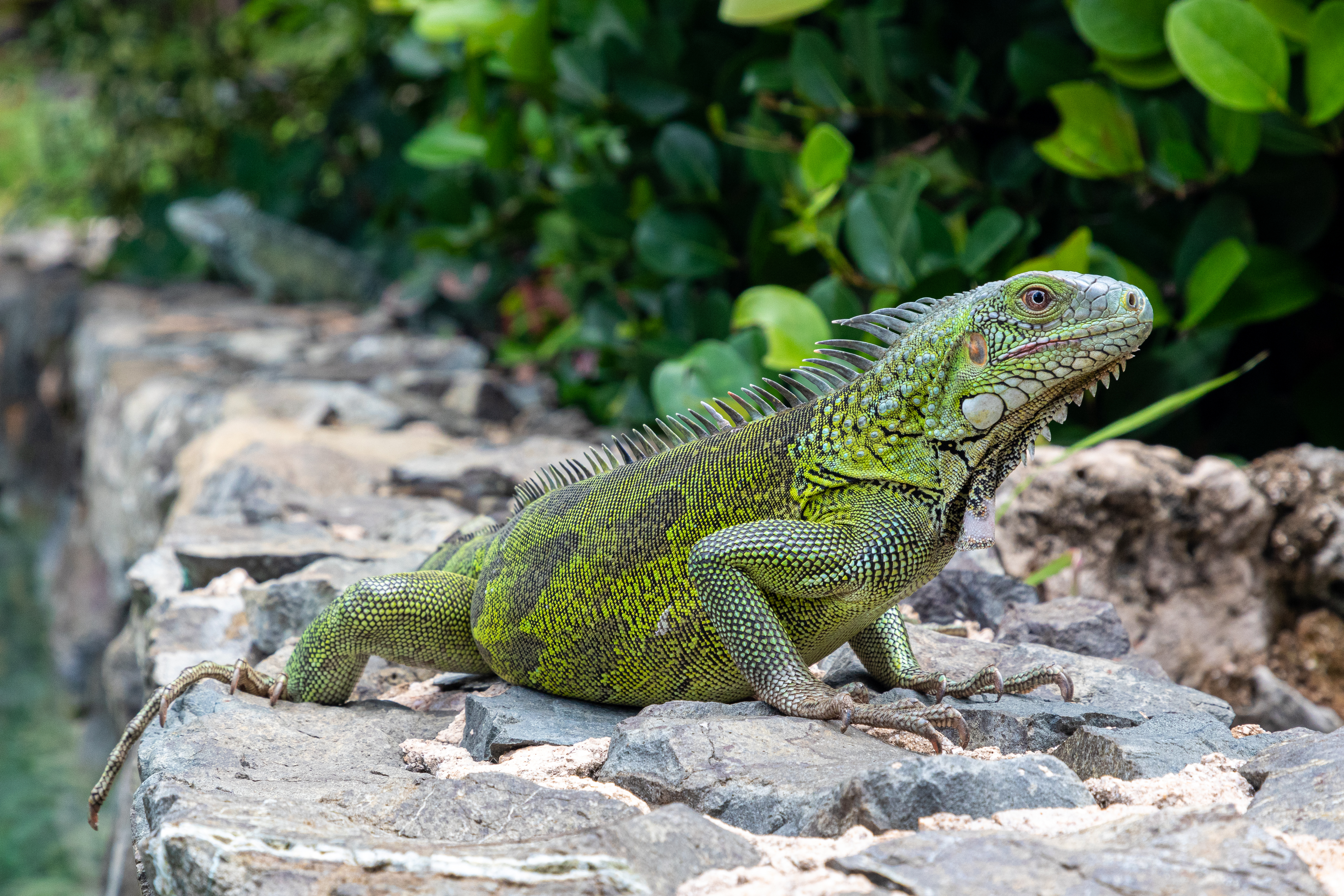
Fauna
Curaçao is semi-arid, and as such has not supported the numerous tropical species of mammals, birds, and lizards most associated with rainforests. Dozens of species of hummingbirds, bananaquits, orioles, and the larger terns, herons, egrets, and even flamingos make their homes near ponds or in coastal areas. The turpial, a black bird with a bright orange underbelly and white swatches on its wings, is common to Curaçao. The mockingbird, called chuchubi in Papiamentu, resembles the North American mockingbird, with a long white-grey tail and a grey back. Near shorelines, big billed brown pelicans feed on fish. Other seabirds include several types of gulls and large cormorants.
Other than field mice, small rabbits, and cave bats, Curaçao's most notable animal is the white-tailed deer. This deer is related to the American white-tailed deer, or Virginia deer, found in areas from North America through Central America and the Caribbean, and as far south as Bolivia. It can be a large deer, some reaching 6 ft in length and 3 ft in height and weighing as much as 300 lb. It has a long tail with a white underside and is the only type of deer on the island. It has been a protected species since 1926, and an estimated 200 live on Curaçao. They are found in many parts of the island, but most notably at the west end's Christoffel Park, where about 70% of the herd resides. Archaeologists believe the deer were brought from South America to Curaçao by its original inhabitants, the Arawaks.
There are several species of iguana, light green in colour with shimmering shades of aqua along the belly and sides, found lounging in the sun across the island. The iguanas found on Curaçao serve not only as a scenic attraction but, unlike many islands that gave up the practice years ago, remain hunted for food. Along the west end of the island's north shore are several inlets that have become home to breeding sea turtles. These turtles are protected by the park system in Shete Boka Park and can be visited accompanied by park rangers.
Historically, Curaçao contained a diverse ecosystem of stygofauna, including members from relictual crustacean groups such as Thermosbaenacea. However, this network of aquatic species, involving numerous endemic taxa, have not been detected since the 1970s. Their abrupt disappearance is hypothesized to have resulted from a combination of habitat destruction and contamination of groundwater by oil and discharge, the result of oil industry activities in the late 1900s.
Climate
Curaçao has a hot, semi-arid climate (Köppen climate classification BSh) with a dry season from January to September and a wet season from October to December. Rainfall is scarce, only 450 mm per year; in particular, the rainy season is drier than it normally is in tropical climates; during the dry season, it almost never rains. Owing to the scarcity of rainfall, the landscape of Curaçao is arid; especially on the north coast of the island. Temperatures are relatively constant, with small differences measured throughout the year. The trade winds cool the island during the day and warm it at night. The coolest month is January with an average temperature of 26.6 °C; the hottest is September with an average temperature of 29.1 °C. The year's average maximum temperature is 31.4 °C. The year's average temperature is 25.7 °C. The seawater around Curaçao averages around 27 °C and is coolest (avg. 25.9 °C) from February to March, and hottest (avg. 28.2 °C) from September to October.
Because Curaçao lies North of the Intertropical Convergence Zone and in an area of low-level divergence where winds flow parallel to the coast, its climate is much drier than expected for the northeastern side of a continent at its latitude. Rainfall is also extremely variable from year to year, being strongly linked to the El Niño Southern Oscillation. As little as 200 mm may fall in a strong El Niño year, but as much as 1150 mm is not unknown in powerful La Niña years.
Curaçao lies outside the Main Development Region for tropical cyclones, but is still occasionally affected by them, as with Hurricanes Hazel in 1954, Anna in 1961, Felix in 2007, and Omar in 2008. No hurricane has made landfall in Curaçao since the US National Hurricane Center started tracking hurricanes. Curaçao has, however, been directly affected by pre-hurricane tropical storms several times; the latest being Hurricane Tomas in 2010, Cesar in 1996, Joan in 1988, Cora and Greta in 1978, Edith and Irene in 1971, and Francelia in 1969. Tomas brushed past Curaçao as a tropical storm, dropping as much as 265 mm of rain on the island, nearly half its annual precipitation in a single day. This made Tomas one of the wettest events in the island's history, as well as one of the most devastating; its flooding killed two people and caused over NAƒ50 million (US$28 million) in damage.
According to the Emissions Database for Global Atmospheric Research, average carbon dioxide emissions per person on the island were 52 tonnes in 2018, the second highest in the world.
Meteo, the Curaçao weather department, provides up-to-date information about weather conditions via its website and mobile apps for iOS and Android. |Jan record high C = 33.3 |Feb record high C = 33.2 |Mar record high C = 33.0 |Apr record high C = 34.7 |May record high C = 36.0 |Jun record high C = 37.5 |Jul record high C = 35.0 |Aug record high C = 37.4 |Sep record high C = 38.3 |Oct record high C = 36.0 |Nov record high C = 35.6 |Dec record high C = 33.4 |year record high C = 38.3 |Jan record low C = 21.5 |Feb record low C = 20.6 |Mar record low C = 21.3 |Apr record low C = 22.0 |May record low C = 21.6 |Jun record low C = 22.4 |Jul record low C = 22.3 |Aug record low C = 21.3 |Sep record low C = 22.7 |Oct record low C = 21.9 |Nov record low C = 22.0 |Dec record low C = 21.6 |year record low C = 20.6
Climate change
Average temperatures have risen sharply in the past 40 years in the Caribbean Netherlands and Curaçao has experienced more warm days and fewer cooler nights. The Intergovernmental Panel on Climate Change predicts that should air temperatures increase by 1.4 degrees, there will be a 5% to 6% decrease in rainfall, increased frequency and intensity of extreme weather events (including a 66% increase in hurricane intensity), and a 0.5- to 0.6-meter sea-level rise in the Caribbean Netherlands.
Geology
Main article: Geology of Curaçao
The northern seabed drops steeply within 60 m of the Curaçaoan shore. This drop-off is known as the "blue edge". On Curaçao, four major geological formations can be found: the lava formation, the Knip formation, the Mid-Curaçao formation and limestone formations.
Curaçao lies within the Caribbean large igneous province (CLIP) with key exposures of those lavas existing on the island consisting of the Curaçao Lava Formation (CLF). The CLF consists of 5 km of pillow lavas with some basalt intrusions. The ages of these rocks include 89 Ma for the lavas and 75 Ma for the poikilitic sills, though some sequences may have erupted as late as 62–66 Ma, placing them in the Cretaceous period. Their composition includes picrite pillows at the base, followed by tholeiitic lavas, then hyaloclastites, then the poikilitic sills. The CLF was gradually uplifted until Eocene-Miocene limestone caps formed, before final exposure above sea level. Christoffelberg and the Zevenbergen (Seven Hills) portion of the island have exposures of the Knip Formation. This formation includes deepwater deposits of calcareous sands and fine clays, capped by siliceous chert containing radiolarians. Middle Curaçao contains alluvial soils from eroded CLF and limestone.
Beaches
.jpg)
Curaçao has 37 beaches. Most are on the south side of the island. The best known are:
- Baya Beach
- Blue Bay
- Boca Sami
- Daaibooi
- Grote Knip (Kenepa Grandi)
- Kleine Knip (Kenepa Chiki)
- Kokomo Beach
- Mambo Beach
- Piscaderabaai
- Playa Forti
- Playa Jeremi
- Playa Kas Abao
- Playa Kalki
- Playa Kanoa
- Playa Lagun
- Playa Porto Marie
- Playa Santa Cruz
- Playa Santa Barbara
- Seaquarium Beach
- Sint Michielsbaai
- Vaersenbaai
- Westpunt
Architecture
The island has diverse architectural styles reflecting the influence of the various historical rulers over the region, including Spain, the Netherlands, with more modern elements under Western influence primarily including the United States and other European countries. This ranges from ruins and colonial buildings to modern infrastructure.
Forts
.jpg)
When the Dutch arrived in 1634, they built forts at key points around the island to protect themselves from foreign powers, privateers, and pirates. Six of the best-preserved forts can still be seen today:
- Fort Amsterdam (1635)
- Fort Beekenburg (1703)
- Fort Nassau (1797)
- Waterfort (1826)
- Rif Fort (1828)
- Fort Piscadera (built between 1701 and 1704)
In 1957, the hotel Van der Valk Plaza Curaçao was built on top of the Waterfort.
The Rif Fort is located opposite of the Waterfort, across the Otrobanda harbour entrance. It contains restaurants and shops, and in 2009, the Renaissance Curaçao Resort and Casino opened next to it.
Politics
After being part of the Netherlands Antilles, Curaçao became autonomous, along with Sint Maarten island, while the less populated islands of Bonaire, Sint Eustatius and Saba remained special municipalities governed by the Netherlands.
Government
Main article: Government of Curaçao

Curaçao is a constituent country of the Kingdom of the Netherlands. Its governance takes place in a framework of a parliamentary representative democracy. The King of the Netherlands is the head of state, represented locally by a governor, with the Prime Minister of Curaçao serving as head of government. Executive power is exercised by the government. Legislative power is vested in both the government and parliament.
The judiciary is independent of the executive and the legislature. Convicted felons are held at the Curaçao Centre for Detention and Correction.
Curaçao has full autonomy over most matters; the exceptions are outlined in the Charter for the Kingdom of the Netherlands under the title "Kingdom affairs".
Military

Defence of the island is the responsibility of the Netherlands. The Netherlands Armed Forces deploy both ground and naval units in the Caribbean with some of these forces based on Curaçao. These forces include:
- a company of the Royal Netherlands Army on Curaçao on a rotational basis;
- a Fast Raiding Interception and Special Forces Craft (FRISC) troop (fast boats);
- a guardship, normally a , from the Royal Netherlands Navy on station in the Caribbean on a rotational basis;
- the Royal Netherlands Navy support vessel ;
- Curmil (Curaçaoan) militia elements;
- Elements of a Royal Marechaussee brigade of the Armed Forces.
Two Dutch naval bases, Parera and Suffisant, are located on the island of Curaçao. Officers of the Arubaanse Militie complete additional training on Curaçao. The Curaçao Volunteer Corps is also stationed at the Suffisant Naval Barracks.
On the west side of Curaçao International Airport are hangars for the two Bombardier Dash 8 Maritime Patrol Aircraft and two AgustaWestland AW139 helicopters of the Dutch Caribbean Coast Guard. Until 2007, the site was a Royal Netherlands Navy air base which operated for 55 years with a wide variety of aircraft, including Fireflies, Avengers, Trackers, Neptunes, Fokker F-27s, P-3C Orions, Fokker F-60s and several helicopter types. After the political decision to sell off all Orions, the air base was not needed anymore.
The west end of the airport is a United States Air Force (USAF) Forward Operating Location (FOL). The base hosts airborne early warning and control systems (AWACS), cargo aircraft, aerial refueling planes, and reconnaissance aircraft. Until 1999, the USAF operated a small fleet of F-16 fighter aircraft from the FOL. The PAE corporation runs base operations at the FOL.
Conscription
Suffisant Naval Base has facilities used for conscription in the Caribbean. There has been no military conscription since 1997, but a form of civil conscription has replaced it, compelling underprivileged young Antilleans to undertake professional training.
Economy
Main article: Economy of Curaçao
.jpg)

Curaçao has an open economy; its most important sectors are tourism, international trade, shipping services, oil refining, oil storage and bunkering, and international financial services. Venezuelan state oil company PDVSA's lease on the island's oil refinery expired in 2019; the facility employs 1,000 people, refining oil from Venezuela for export to the United States and Asia. Schlumberger, the world's largest oil field services company, is incorporated in Curaçao. The is said to be responsible for Curaçao's position as one of the world's top five highest per capita CO2 emission-producing countries.
Along with Sint Maarten, Curaçao uses the Caribbean guilder. On 1 July 2025 it formally discontinued the previous currency, the Netherlands Antillean guilder. Its economy is well-developed, supporting a high standard of living, ranking 46th in the world in terms of GDP (PPP) per capita and 27th in the world in terms of nominal GDP per capita. Curaçao possesses a high-income economy as defined by the World Bank.
Activities related to the port of Willemstad, such as the Free Trade Zone, make significant contributions to the economy. To achieve greater economic diversification, the Curaçaoan government is increasing its efforts to attract more foreign investment. This policy, called the "Open Arms" policy, features a heavy focus on attracting information technology companies.
Since 2016, reduced foreign demand for goods due to the ongoing unrest and political uncertainty in Venezuela has led to decreased exports and increased domestic demand for goods and services, resulting in economic stagnation. While many economic sectors contracted, expansion took place in the construction, financial intermediation, and utilities sectors.
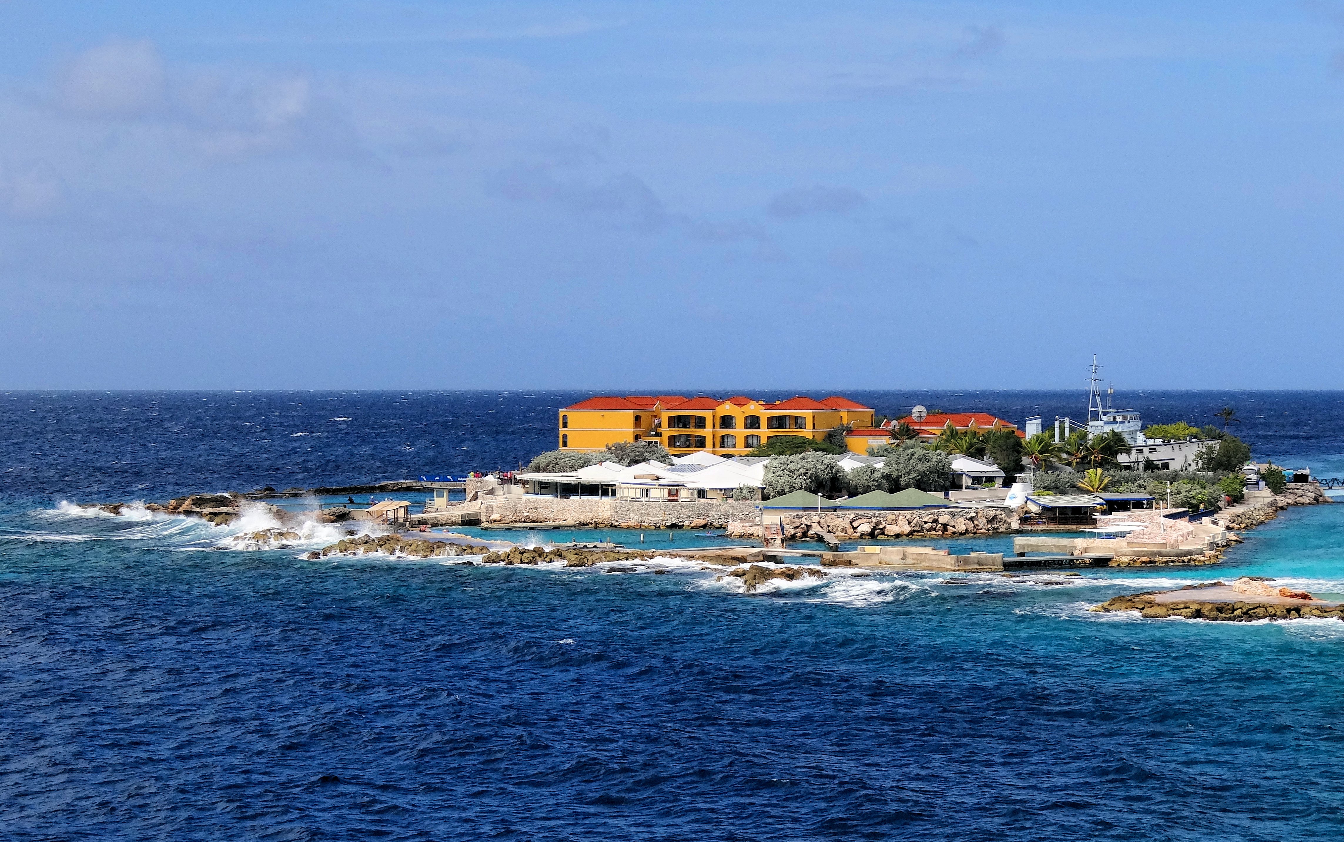
Tourism
.jpg)
While tourism plays a major role in Curaçao's economy, the island is less reliant on tourism than many other Caribbean countries. Most tourists come to Curaçao from the Netherlands, the eastern United States, South America and other Caribbean islands. Curaçao was a Caribbean leader in cruise ship tourism growth, with 610,186 cruise passengers in 2013, a 41.4% increase over the previous year. Hato International Airport received 1,772,501 passengers in 2013 and announced capital investments totaling US$48 million aimed at transforming the airport into a regional hub by 2018.
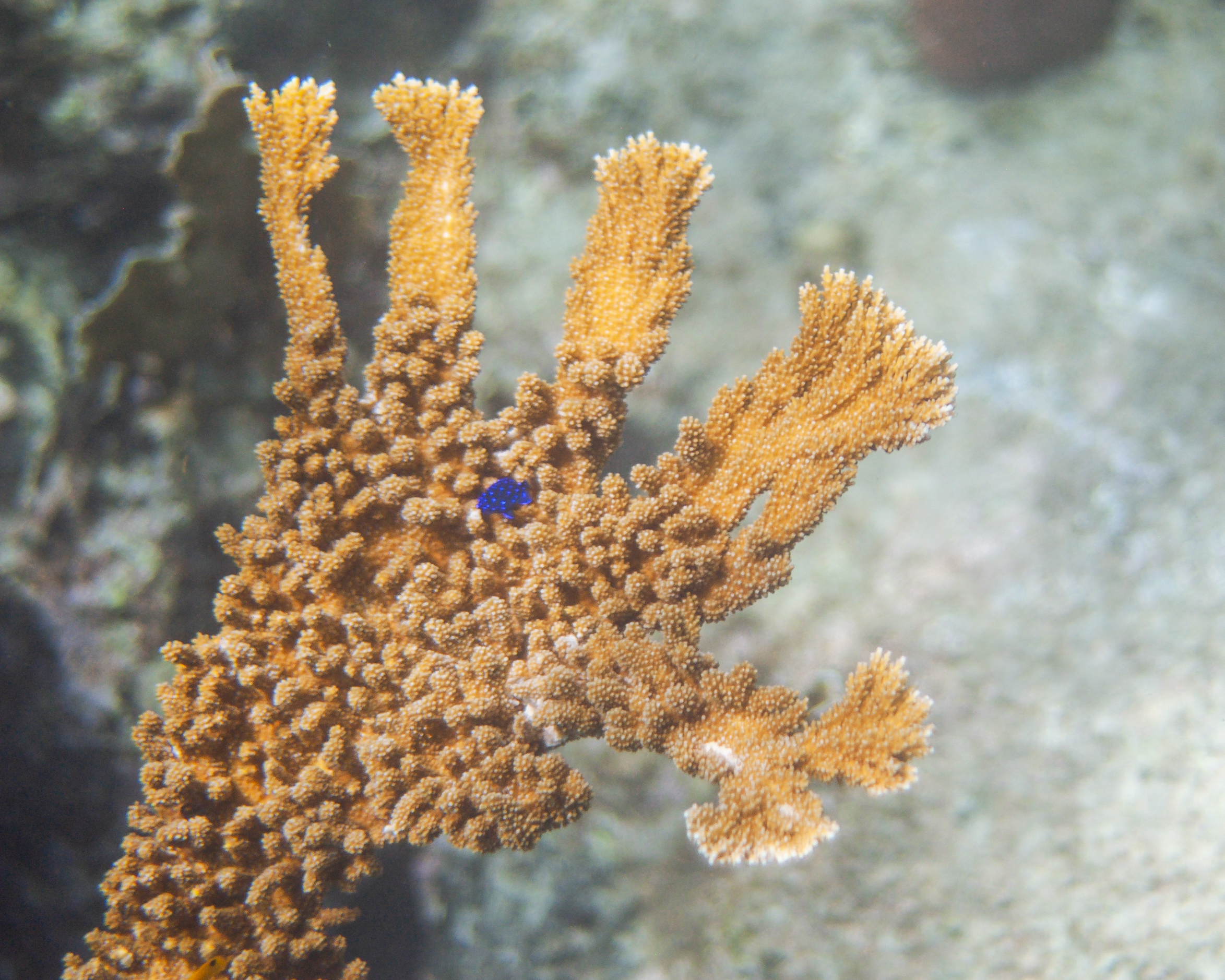
The Curaçaoan insular shelf's sharp drop-off known as the "Blue Edge" is often visited by scuba diving tourists. Coral reefs for snorkeling and scuba diving can be reached without a boat. The southern coast has calm waters as well as many small beaches, such as Jan Thiel and Cas Abou. At the westernmost point of the island is Watamula and the Cliff Villa Peninsula which are good locations for drift diving. The coastline of Curaçao features numerous bays and inlets which serve as popular mooring locations for boats.
In June 2017, the island was named the Top Cruise Destination in the Southern Caribbean by Cruise Critic, a major online forum. The winners of the Destination Awards were selected based on comments from cruise passengers who rated the downtown area of Willemstad as "amazing" and the food and shopping as "excellent". The historic centre of Willemstad is a World Heritage Site. Another attraction is the town's colourful street art. The Blue Bay Sculpture Garden with works from known Curaçao artists is situated in a nearby resort. Landhuis Bloemhof is an art museum and gallery located in Willemstad.
Some of the coral reefs are affected by tourism. Porto Marie Beach is experimenting with artificial coral reefs to improve the reef's condition. Hundreds of artificial coral blocks that have been placed are now home to a large array of tropical fish. It is now under investigation to see if the sewer waste of hotels is a partial cause of the dying of the coral reef.
Ecotourism is a growing segment of Curaçaoan tourism. One site in particular – Mambo Beach, also known as "Seaquarium Beach" – is a popular destination due to the calm tides for children, frequent viewing of marine life, and vibrant coral reefs – some of which have been artificially planted to improve reef health.
Labour
In 2016, a Labour Force Survey (LFS) indicated that the unemployment rate was 13.3%. For residents ages 15–64, the employment rate was 70.4%.
Financial services
Curaçao's history in financial services dates back to the First World War. Prior to this period, the financial arms of local merchant houses functioned as informal lenders to the community. However, at the turn of the 20th century, Curaçao underwent industrialization, and a number of merchant houses established private commercial banks. As the economy grew, these banks began assuming additional functions eventually becoming full-fledged financial institutions.
The Dutch Caribbean Securities Exchange is located in the capital of Willemstad, as is the Central Bank of Curaçao and Sint Maarten; the latter of which dates to 1828. It is the oldest central bank in the Western Hemisphere. The island's legal system supports a variety of corporate structures and is a corporate haven. Though Curaçao is considered a tax haven, it adheres to the EU Code of Conduct against harmful tax practices. It holds a qualified intermediary status from the United States Internal Revenue Service. It is an accepted jurisdiction of the OECD and Caribbean Financial Action Task Force on Money Laundering.
Foreign Account Tax Compliance Act

On 30 June 2014, Curaçao was deemed to have an Inter-Governmental Agreement (IGA) with the United States of America with respect to the "Foreign Account Tax Compliance Act" of the United States of America. The Tax Information Exchange Agreement signed in Washington, D.C., on 17 April 2002 between the U.S. and the Kingdom of the Netherlands includes Curaçao, and was updated with respect to Curaçao in 2014, taking effect in 2016.
Trade
Curaçao trades mainly with the United States, Venezuela, and the European Union. It has an Association Agreement with the European Union which allows companies which do business in and via Curaçao to export products to European markets, free of import duties and quotas. It is also a participant in the US Caribbean Basin Initiative allowing it to have preferential access to the US market.
Prostitution
Prostitution in Curaçao is legal only for foreign women who get a temporary permit to work in the large open-air brothel called "Le Mirage" or "Campo Alegre". Using prostitution services is legal for men (locals included). The brothel has operated near the airport since the 1940s. Curaçao monitors, contains and regulates the industry. The government states that the workers in these establishments are thereby given a safe environment and access to medical practitioners. However this approach does exclude local women (or men) to legally make a living from prostitution and does lead to loss of local income, as the foreign prostitutes send or take most of their earnings home.
Developments of Campo Alegre (2020–2024)
Since its closure in 2020 after 71 years of operation, Campo Alegre, Curaçao's largest open-air brothel, has been at the center of significant developments. Following the closure, a government-appointed working group proposed three scenarios for the site: transforming it into a regulated prostitution area, repurposing it for commercial use, or converting it into a residential area. In 2023, the property was put up for auction, attracting various potential buyers. In a significant move, the Curaçao government purchased the Campo Alegre property, aiming to have more control over its future use. The current ruling political party, Movement for the Future of Curaçao (MFK), had made an election promise to reopen Campo Alegre as a regulated prostitution center. This promise aligns with the recommendations of the working group and reflects the party's stance on creating a controlled environment for sex work. As of 2024, the government is evaluating scenarios to ensure that the chosen path will benefit the local economy and social landscape. The U.S. State Department has cited anecdotal evidence claiming that, "Curaçao...[is a] destination island... for women trafficked for the sex trade from Peru, Brazil, Colombia, the Dominican Republic, and Haiti, according to local observers. At least 500 foreign women reportedly are in prostitution throughout the five islands of the Antilles, some of whom have been trafficked." The US Department of State has said that the government of Curaçao frequently underestimates the extent of human trafficking problems.
Demographics


Owing to the island's colonial past, the majority of Curaçao's population is of full or partial African descent. There are also minorities of Dutch, Portuguese, Jewish, Latin American, South Asian, East Asian and Lebanese descent. Portuguese laborers, namely from Madeira, migrated to Curaçao to work in the island's oil and agricultural industries in the 20th century. According to 2022 data from the CIA, Curacao has a total of only 92 men for every 100 women.
Religion
The religious breakdown of the population of Curaçao, according to a 2011 estimate:
- Roman Catholic: 69.8%
- Adventist: 9%
- Evangelical: 8.9%
- Pentecostal: 7.6%
- Other Protestant: 3.2%
- Jehovah's Witnesses: 2%
- Other: 3.8%
- None: 10%
- Unspecified: 0.6%
The Roman Catholic Diocese of Willemstad encompasses all the territory of the Kingdom of the Netherlands in the Caribbean which includes Aruba, Curaçao, Sint Maarten, and the islands of Bonaire, St. Eustatius and Saba. The diocese is also a member of the Antilles Episcopal Conference.
There has been a shift towards the Charismatic movement in recent decades. Other denominations include the Seventh-day Adventist Church and the Methodist Church. Alongside these Christian denominations, some inhabitants practise Montamentu and other diaspora African religions. As elsewhere in Latin America, Pentecostalism is on the rise. There are also practising Muslims and Hindus.
While small, Curaçao's Jewish community has had a significant impact on the island's history. Curaçao has the oldest active Jewish congregation in the Americas, dating to 1651. The Curaçao synagogue is the oldest synagogue of the Americas in continuous use, since its completion in 1732 on the site of a previous synagogue. Additionally, there are both Sephardic and Ashkenazi Jewish communities. As of the year 2000 there were approximately 300 Jewish people living on the island.
Languages
According to the 2023 census, 78% reported that Papiamentu was the language they most spoke at home; 8.4% reported Spanish, 7.9% Dutch, 3.8% English and 2% other languages.
Curaçao is a multilingual society. The official languages are Dutch, Papiamentu and English. However, Dutch is the sole language for all administration and legal matters. Most of Curaçao's population is able to converse in at least two, though more commonly in all four of the languages of Papiamentu, Dutch, English, and Spanish.
The most widely spoken language is Papiamentu, a Portuguese-based creole with African, Dutch and Spanish influences, which is spoken in all levels of society. Papiamentu was introduced as a language of primary school education in 1993, making Curaçao one of a handful of places where a creole language is used as a medium to acquire basic literacy.
Spanish and English also have a long historical presence in Curaçao. Spanish became an important language in the 18th century due to the close economic ties with Spanish territories in what are now Venezuela and Colombia. Use of English dates to the early 19th century, when the British occupied Curaçao, Aruba and Bonaire. When Dutch rule resumed in 1815, officials already noted the widespread use of the English language.
Localities
Curaçao was divided into five districts from 1863 to 1925, after which it was reduced to the two outer districts of Bandabou and Bandariba and the city district of Willemstad. Over the years, the capital, Willemstad, encompassed the entire area surrounding the large natural harbour, the Schottegat. As a result, many formerly isolated villages have grown together to form a large urbanised area. The city covers approximately one third of the entire island in the east. Willemstad's most famous neighbourhoods are:
- Punda, the historic city centre with the Handelskade on St. Anna Bay.
- Otrobanda, on the other side of St. Anna Bay
- Pietermaai, east of Punda
- Scharloo, north of Punda and Pietermaai, across the Waaigat
- Julianadorp, a suburb on the west side of the city, built around 1928 on behalf of Shell for its personnel
- Emmastad, built for Shell in the 1950s, after Julianadorp was full.
- Saliña is situated next to Punda and has many shops and restaurants.
- Brievengat, a suburb in the north of the city.
Structure of the population
| Age group | Male | Female | Total | % | Age group | Male | Female | Total | Percent |
|---|---|---|---|---|---|---|---|---|---|
| Total | 69 285 | 83 084 | 152 369 | 100 | |||||
| 0–4 | 3 876 | 3 637 | 7 513 | 4.93 | |||||
| 5–9 | 4 750 | 4 479 | 9 229 | 6.06 | |||||
| 10–14 | 4 487 | 4 401 | 8 888 | 5.83 | |||||
| 15–19 | 4 503 | 4 393 | 8 895 | 5.84 | |||||
| 20–24 | 3 891 | 3 665 | 7 556 | 4.96 | |||||
| 25–29 | 3 862 | 4 280 | 8 142 | 5.34 | |||||
| 30–34 | 3 966 | 4 774 | 8 740 | 5.74 | |||||
| 35–39 | 4 081 | 5 091 | 9 172 | 6.02 | |||||
| 40–44 | 3 833 | 5 099 | 8 932 | 5.86 | |||||
| 45–49 | 4 563 | 5 790 | 10 353 | 6.79 | |||||
| 50–54 | 5 049 | 6 323 | 11 372 | 7.46 | |||||
| 55–59 | 5 481 | 7 013 | 12 493 | 8.20 | |||||
| 60–64 | 4 937 | 6 576 | 11 513 | 7.56 | |||||
| 65–69 | 4 098 | 5 523 | 9 621 | 6.31 | |||||
| 70–74 | 3 427 | 4 506 | 7 932 | 5.21 | |||||
| 75–79 | 2 163 | 3 342 | 5 504 | 3.61 | |||||
| 80–84 | 1 346 | 2 146 | 3 492 | 2.29 | |||||
| 85–89 | 661 | 1 283 | 1 944 | 1.28 | |||||
| 90–94 | 248 | 543 | 791 | 0.52 | |||||
| 95–99 | 59 | 192 | 250 | 0.16 | |||||
| 100+ | 8 | 35 | 43 | 0.03 | |||||
| 0–14 | 13 113 | 12 517 | 25 630 | 16.82 | |||||
| 15–64 | 44 162 | 52 997 | 97 159 | 63.77 | |||||
| 65+ | 12 010 | 17 570 | 29 580 | 19.41 |
Statistics

Education

Public education is based on the Dutch educational system and besides the public schools, private and parochial schools are also available. Since the introduction of a new public education law in 1992, compulsory primary education starts at age six and continues for six years; secondary lasts for another four.
The main institute of higher learning is the University of Curaçao (formerly University of The Netherlands Antilles), enrolling 2,100 students. The comprehensive model of education is influenced by both the Dutch and American education systems. Other higher education offerings on the island include offshore medical schools, universities, language schools and academies for fine art, music, police, teacher and nurse-training.
Culture

Visual art
Visual art in Curaçao encompasses painting, sculptures, and street art.
Curaçao promotes street art with a festival, Kaya Kaya, held in the Otrabanda neighborhood of Willemstad. The streets of Willemstad are filled with murals from multiple versions of the festival.
Literature
Despite the island's relatively small population, the diversity of languages and cultural influences on Curaçao have generated a remarkable literary tradition, primarily in Dutch and Papiamentu. The oral traditions of the Arawak indigenous peoples are lost. Enslaved West Africans carried the tales of Anansi, thus forming the basis of Papiamentu literature. The first published work in Papiamentu was a poem by Joseph Sickman Corsen entitled Atardi, published in the La Cruz newspaper in 1905. Throughout Curaçaoan literature, narrative techniques and metaphors best characterized as magic realism tend to predominate. Novelists and poets from Curaçao have contributed to Caribbean and Dutch literature. Best known are Cola Debrot, Frank Martinus Arion, Pierre Lauffer, , Guillermo Rosario, and Tip Marugg.
Cuisine
Local food is called Krioyo (pronounced the same as criollo, the Spanish word for "Creole") and boasts a blend of flavours and techniques best compared to Caribbean cuisine and Latin American cuisine. Dishes common in Curaçao are found in Aruba and Bonaire as well. Popular dishes include stobá (a stew made with various ingredients such as papaya, beef or goat), guiambo (soup made from okra and seafood), kadushi (cactus soup), sopi mondongo (intestine soup), funchi (cornmeal paste similar to fufu, ugali and polenta) and fish and other seafood. The ubiquitous side dish is fried plantain. Local bread rolls are made according to a Portuguese recipe. All around the island, there are snèks which serve local dishes as well as alcoholic drinks in a manner akin to the English pub.
The ubiquitous breakfast dish is pastechi: fried pastry with fillings of cheese, tuna, chicken, or ground meat. Around the holiday season special dishes are consumed, such as the hallaca and pekelé, made out of salt cod. At weddings and other special occasions a variety of kos dushi are served: kokada (coconut sweets), ko'i lechi (condensed milk and sugar sweet) and tentalaria (peanut sweets). The Curaçao liqueur was developed here, when a local experimented with the rinds of the local citrus fruit known as laraha. Surinamese, Chinese, Indonesian, Indian and Dutch culinary influences also abound. The island also has a number of Chinese restaurants that serve mainly Indonesian dishes such as satay, nasi goreng and lumpia (which are all Indonesian names for the dishes). Dutch specialties such as croquettes and oliebollen are widely served in homes and restaurants.
Sports
.jpg)
In 2004, the Little League Baseball team from Willemstad, Curaçao, won the world title in a game against the United States champion from Thousand Oaks, California. The Willemstad lineup included Jurickson Profar, the standout shortstop prospect who is currently on the Atlanta Braves roster of Major League Baseball, and Jonathan Schoop.
Curaçaoan players Andruw Jones, Ozzie Albies, and Kenley Jansen have made multiple Major League Baseball All-Star Game appearances.
The 2010 documentary film Boys of Summer details Curaçao's Pabao Little League All-Stars winning their country's eighth straight championship at the 2008 Little League World Series, then going on to defeat other teams, including Puerto Rico and the Dominican Republic, and earning a spot in Williamsport.
The prevailing trade winds and warm water make Curaçao a location for windsurfing.
There is warm, clear water around the island. Scuba divers and snorkelers may have visibility up to 30 m at the Curaçao Underwater Marine Park, which stretches along 20 km of Curaçao's southern coastline.
Curaçao participated in the 2013 CARIFTA Games. Kevin Philbert stood third in the under-20 male Long Jump with a distance of 7.36 m. Vanessa Philbert stood second the under-17 female 1500 m with a time of 4:47.97.
The Curaçao national football team won the 2017 Caribbean Cup by defeating Jamaica in the final, qualifying for the 2017 CONCACAF Gold Cup. They then traveled to Thailand and participated in the 2019 King's Cup for the first time, eventually winning the tournament by beating Vietnam in the final.
In 2025, Curaçao qualified for the 2026 FIFA World Cup, becoming the smallest nation in history to reach the World Cup finals.
Infrastructure and transportation
Airport
Curaçao International Airport (also called Hato International Airport) is located on the northern coast of the island and offers connections to the Caribbean region, South America, North America and Europe. Curaçao Airport is a fairly large facility, with the third longest commercial runway in the Caribbean region after Rafael Hernández Airport in Puerto Rico and Pointe-à-Pitre International Airport in Guadeloupe. Curaçao international airport served as a main base for Insel Air, and for Air ALM, the former national airlines of Curaçao.
Railways
In 1887 a horse drawn street tramway opened in Punda, the part of the capital Willemstad on the eastern side of Sint Annabaai. It had a U-shaped route about 2 km in length. In 1896, a tramway opened in Otrabanda on the opposite side of the bay, but it ceased operations within a few months. The Punda line was rebuilt in 1911, regauged to metre gauge, and the horse-drawn trams replaced by petrol engined ones. The line closed in 1920.
Public transportation
ABC (Auto Busbedrijf Curaçao, "Curaçao Bus Company") provides bus transportation in and around Willemstad with 21 lines, all departing from either Otrabanda and Punda bus stations, including lines 4A, 2A, 2B and 2C serving the airport. Fares range from 2.00 to 2.50 guilders.
Bridges


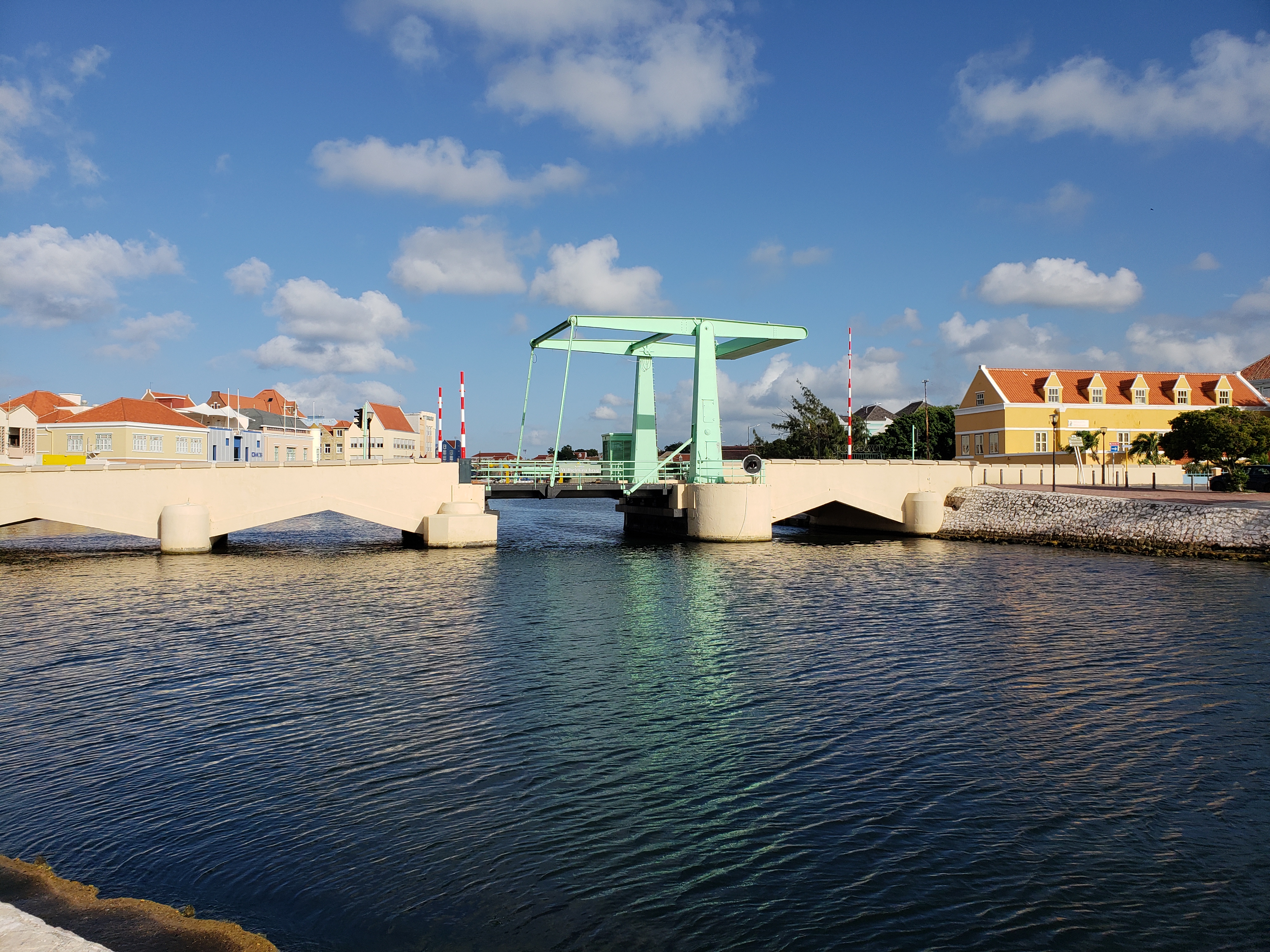
The Queen Emma Bridge, a 168 m-long pontoon bridge, allows pedestrians to walk between the Punda and Otrobanda districts. The bridge swings open to allow the passage of ships to and from the port. The bridge was originally opened in 1888 and the current bridge was installed in 1939. It is best known and, more often than not, referred to by the locals as "Our Swinging Old Lady".
The Queen Juliana Bridge carries motor vehicle traffic between the same two districts and its 1974 opening allowed the Queen Emma Bridge to become a pedestrian-only bridge. At 185 ft above the sea, the Queen Juliana Bridge is one of the highest bridges in the Caribbean.
Utilities and sanitation
Aqualectra, a government-owned company and a full member of CARILEC, delivers potable water and electricity to the island. Rates are controlled by the government. Water is produced by reverse osmosis or desalinization. It services 69,000 households and companies using 130,000 water and electric meters. The power generation company NuCuraçao opened wind farms in Tera Kora and Playa Kanoa in 2012, and expanded in Tera Kora in 2015. There is no natural gas distribution grid; gas is supplied to homes by pressurized containers.
Curbside trash pickup is provided by the Selikor company. There is no recycling pickup, but there are drop-off centers for certain recycled materials at the Malpais landfill, and various locations operated by Green Force; private haulers recycle construction waste, paper, and cardboard.
Notable residents
Main article: List of Curaçaoans
Notes
References
Sources
- Habitantenan di Kòrsou, sinku siglo di pena i gloria: 1499–1999. Römer-Kenepa, NC, Gibbes, FE, Skriwanek, MA., 1999. Curaçao: Fundashon Curaçao 500.
- Social movements, violence, and change: the May Movement in Curaçao. WA Anderson, RR Dynes, 1975. Columbus: Ohio State University Press.
- Stemmen uit het Verleden. Van Buurt, G., Joubert, S., 1994, Curaçao.
- Het Patroon van de Oude Curaçaose Samenleving. Hoetink, H., 1987. Amsterdam: Emmering.
- Dede pikiña ku su bisiña: Papiamentu-Nederlands en de onverwerkt verleden tijd. van Putte, Florimon., 1999. Zutphen: de Walburg Pers
References
- "Curacao". Central Intelligence Agency.
- (19 May 2015). "Waaruit bestaat het Koninkrijk der Nederlanden?".
- (April 2023). "First results 2023 pop census Curaçao".
- van der Molen, Maarten. (19 September 2013). "Country Report Curaçao".
- "Curacao".
- (20 December 2013). "Human Development Index (HDI): Korte Notitie inzake de berekening van de voorlopige Human Development Index (HDI) voor Curaçao". Centraal Bureau voor de Statistiek.
- Wells, John C.. (2008). "Longman Pronunciation Dictionary". Longman.
- {{cite Dictionary.com. Curaçao
- Mangold, Max. (2005). "Aussprachewörterbuch". Duden Verlag.
- "Art. 1 para 1 Constitution of Curaçao".
- "Art. 1 para 1 Constitution of Curaçao".
- "CIA World Factbook- Curaçao".
- (1 July 2023). "Caribbean Cultural Heritage and the Nation : Aruba, Bonaire and Curaçao in a Regional Context". Amsterdam University Press.
- Öörni, Juha. (6 October 2017). "Traveler's Paradise—ABC Islands: Travel Guide for ABC Islands (Aruba, Bonaire, Curaçao)".
- ({{langx. nl. Eilandgebied Curaçao. Papiamentu]]: ''Teritorio Insular di Kòrsou'').
- The English name is used by the governments of Curaçao and Netherlands Antilles, as English was an official language of the Netherlands Antilles and the Island Territory of Curaçao.
- "De komst van de olieraffinaderij op Curaçao".
- "Rijkswet wijziging Statuut in verband met de opheffing van de Nederlandse Antillen (32.213 (R1903))".
- Joubert and Van Buurt, 1994
- "Curacao Nature".
- "Cock's 1562 map, Library of Congress website".
- "The History of Curaçao".
- Kraan, Claudia T.. (1 October 2024). "Radiocarbon dates from Curaçao's oldest Archaic site extend earliest island settlement to ca. 5700 cal BP". The Journal of Island and Coastal Archaeology.
- McColl, Richard. (2013-03-26). "The forgotten conquistador {{!}} The City Paper Bogotá". The City Paper Bogotá.
- "1704 {{!}} Birth of papiamentu – Curaçao History".
- "1499 {{!}} Amerigo Vespucci – Curaçao History".
- "ABOUT CURACAO - Tour Hopping Curacao". Tour Hopping Curacao.
- "Curaçao {{!}} Dutch Caribbean {{!}} Photos {{!}} OzOutback".
- "Curacao Virtual Jewish History Tour".
- "The story of Curacao | History".
- "Curaçao History". Papiamentu.net.
- Rodriguez, Junius P.. (2007). "Encyclopedia of Slave Resistance and Rebellion". Greenwood Publishing Group.
- "Octagon Museum – Curaçao Art".
- "Curacao in the British Empire".
- "The History of Curaçao".
- Called "Paga Tera"
- ''Dede pikiña ku su bisiña: Papiamentu-Nederlands en de onverwerkt verleden tijd''. van Putte, Florimon., 1999. Zutphen: de Walburg Pers
- Van Putte 1999.
- "Overval op fort Amsterdam in Willemstad op Curaçao door de Venezolaanse revolutionair Urbina (8 juni 1929)". Ministry of Defense.
- (7 April 2024). "WHKMLA: List of Wars of the Dutch Republic / Netherlands".
- Anderson & Dynes 1975, p. 81, Oostindie & Klinkers 2013, p. 98, "Striking Oil Workers Burn, Loot in Curacao". ''Los Angeles Times''. 31 May 1969, p. 2.
- Anderson & Dynes 1975, pp. 100–101, Sharpe 2015, p. 122, Verton 1976, p. 90, "Nieuwe ministers legden eed af" (in Dutch). ''Amigoe di Curaçao''. 12 December 1969, p. 1.
- (30 June 2008). "Curaçao refinery sputters on, despite emissions". Reuters.
- "The Dutch migration monitor: Backgrounds and developments of different types of international migration".
- The Daily Herald St. Maarten. (9 July 2007). "Curaçao IC ratifies 2 November accord".
- Cuales, Orlando. (15 May 2009). "Curacao Referendum Approves Increasing Autonomy". Newser.
- Koninkrijksrelaties, Ministerie van Binnenlandse Zaken en. (13 December 2011). "New constitutional order – Caribbean Parts of the Kingdom – Government.nl".
- (18 November 2009). "NOS Nieuws – Antillen opgeheven op 10-10-2010". Nos.nl.
- "Dutch Antilles no longer exists". BBC News.
- "Curacao heeft een tussenkabinet, dat vooral moet bezuinigen". nrc.nl.
- "Regering Curaçao beëdigd".
- (4 July 2017). "Curaçao Prime Minister wants to do business with the Netherlands".
- (17 July 2017). "Premier Rhuggenaath participates High Level Political Forum in New York".
- (10 July 2017). "On numerous occasions the Netherlands has offered assistance with Oil Refinery negotiations".
- "Protest Curaçao eindigt in rellen en plunderingen, avondklok ingesteld".
- Vordev. "Angry protestors heading towards Fort Amsterdam".
- (24 June 2020). "Plunderingen in Willemstad uitgaansverbod".
- (25 June 2020). "Curaçao protest gets out of hand".
- "48 personen gearresteerd".
- Vordev. "Punda and Otrobanda in lockdown until Friday; Curfew tonight from 8:30pm until 6am".
- (October 2009). "Checklist of the Birds of Aruba, Curaçao and Bonaire, South Caribbean". Ardea.
- (October 2022). "Community Extinction: The Groundwater (Stygo-)Fauna of Curaçao, Netherlands, Antilles". Hydrobiologia.
- "Climate Summary".
- Dewar, Robert E. and Wallis, James R; ‘Geographical patterning in interannual rainfall variability in the tropics and near tropics: An L-moments approach’; in ''[[Journal of Climate]]'', 12; pp. 3457–3466
- (1 November 2010). "Doden door noodweer op Curaçao". Netherlands National News Agency.
- (2 November 2010). "Damdoorbraken in Curaçao door storm Tomas". Nieuws.nl.
- Elisa Koek. (6 November 2010). "50 miljoen schade". versgeperst.com.
- Redactie Aworaki. (2 November 2010). "Twee doden op Curaçao door Tropische Storm Tomas". Aworaki.nl.
- (26 September 2019). "Fossil CO2 and GHG emissions of all world countries: 2019 report.". Publications Office of the European Union.
- "Weather App".
- "Summary Climatological Data 1981–2010". Meteorological Department Curacao.
- Vordev. "'Climate change becomes an existential crisis on the islands'".
- "Geology {{!}} Research Station CARMABI".
- (2011). "Prolonged volcanic history for the Curaçao Lava Formation inferred from new 40Ar-39Ar ages and trace phase geochemistry". American Geophysical Union, Fall Meeting 2011, Abstract Id. V51D-2542.
- (2010). "A Short Natural History of Curaçao. In: Crossing Shifting Boundaries, Language and Changing Political status in Aruba, Bonaire and Curaçao". Proceedings of the ECICC-conference, Dominica 2009.
- Ruepert, Maaike. (25 November 2014). "De 37 stranden van Curaçao in kaart".
- Kateman, Thijs. (2012). "Curacao, Aruba en Bonaire / druk 1: Binaire en Aruba". ANWB Media – Boeken & Gidsen.
- (2011) GEA Curaçao. Ref. AR 48811 – [http://www.slideshare.net/jronger/110429-verzoekschrift-bodemprocedure Aqua Spa B.V. vs Renaissance Curaçao Resort & Casino (Riffort Village N.V.) – Riffort Village Exploitatie Maatschappij N.V. – Aruba Bank N.V.] {{Webarchive. link. (21 October 2023)
- "Beslag renaissance curacao resort & casino bank amigoe".
- "Curacao profile". BBC News.
- Affairs, Ministry of General. (22 December 2014). "Charter for the Kingdom of the Netherlands – Legislation – Royal House of the Netherlands".
- (October 2010). "Militaire (on-)zichtbaarheid op Curaçao; cultuur in conflict".
- Kranendonk, Cherique. (16 November 2015). "Professionalisering Curaçaose Militie zet door". Defensie.nl.
- Defensie, Ministerie van. "Units and locations".
- Defensie, Ministerie van. "Commandement der Zeemacht Caribisch Gebied".
- Defensie, Ministerie van. "Units and locations".
- "Curacao/Aruba Forward Operating Locations".
- "Contracts for October 30, 2020". U.S. Department of Defense.
- Defensie, Ministerie van. "Commander Netherlands Forces in the Caribbean".
- "Dutch Caribbean Refineries On Uncertain Path – Carib Flame".
- "Curacao Economy 2017, CIA World Factbook".
- "Schlumberger N.V. – Company Information".
- "COP21 alert: Caribbean part of Dutch Kingdom belongs to top 5 CO2 emissions per capita {{!}} Stichting SMOC".
- (31 March 2025). "Caribbean Guilder Officially Legal Tender in Curaçao and Sint Maarten". [[Central Bank of Curaçao and Sint Maarten]].
- "Excel file of historical classifications by income.".
- "How are the income group thresholds determined? – World Bank Data Help Desk".
- "An investor's guide to the welcoming island of Curaçao".
- Mindmagnet.com. (1 March 2001). "Ecommerce at Curaçao Corporate". Ecommerceatcuracao.com.
- "Economic Data Overview". Investcuracao.com.
- (14 February 2017). "Economic Developments in 2016 and outlook for 2017 / Economische ontwikkelingen in 2016 en vooruitzichten voor 2017 – Curacao / Sint Maarten – BearingPoint Caribbean".
- (14 February 2014). "Curaçao Leading Caribbean in Cruise Tourism Growth". Caribjournal.com.
- "An Underwater Photographer's Guide to Curaçao".
- "Curacao vakantie – Curacao vakantie".
- (27 July 2017). "Curaçao has been named the Top Cruise destination in the Southern Caribbean".
- "Blue Bay Beeldentuin".
- "Landhuis Bloemhof".
- NTR, Omroep. "Vernietigt toeristenpoep ons Nederlandse koraal?".
- (13 October 2022). "Why Curacao is a great destination for ecotourists".
- "Home".
- (1 February 2017). "Statistics: "Unemployment rate rose to 13.3 percent"".
- (3 March 2017). "Supply Side of the Labour Market Curaçao: Labour Force Survey 2016 – BearingPoint Caribbean".
- (11 December 2002). "Twentieth Century Private Banking – Roots of Our Future". caribseek.com.
- (1 February 2003). "In 175 years the Bank has evolved from a near dormant institution in the nineteenth century to a vibrant organization able to adapt to the ever changing financial world in the twenty-first century". centralbank.an.
- U.S. Treasury [https://www.treasury.gov/resource-center/tax-policy/treaties/Pages/FATCA.aspx FACTA] {{Webarchive. link. (13 January 2017 .)
- U.S. Treasury [https://www.treasury.gov/resource-center/tax-policy/treaties/Documents/FATCA-Agreement-Curacao-12-16-2014.pdf Agreement with Curaçao] {{Webarchive. link. (3 April 2017 (pdf).)
- (24 June 2007). "EU Trade Program". archive.org.
- (1 October 2000). "USTR – Caribbean Basin Initiative". Ustr.gov.
- (26 November 2012). "Sex Tourism And Trafficking In The Dutch Caribbean".
- "Curaçao Opens Campo Alegre Brothel".
- (2009). "Curaçao's X-Rated Resort". Global Writes.
- "AntilliaansDagblad {{!}} Werkgroep adviseert regering over heropening bordeel {{!}} Knipselkrant Curacao". Antilliaans Dagblad.
- Drayer, Dick. (2022-06-16). "Campo Alegre, 's werelds grootste bordeel op het westelijk halfrond gaat dinsdag onder de hamer - Curacao.nu". Curacao.nu.
- "Groot openluchtbordeel Curaçao sluit na 71 jaar, maar voor hoelang?".
- Selim, Amallah. (2024-09-01). "tr88".
- "Country Narratives -- Countries H through R". U.S. Department of State.
- Curacao, U. S. Consulate in. (17 November 2022). "History of Curacao, St. Maarten, Bonaire, St. Eustatius, and Saba".
- (2014). "PORTUGUESE LABOR MIGRATION TO CURAÇAO". Caribbean Studies.
- "Countries with More Women Than Men 2024".
- (19 October 2021). "Central America and Caribbean: Curaçao". CIA The World Factbook.
- "Annual Plenary Meeting 2023 – Diocese of Willemstad". Antilles Episcopal Conference.
- (1981). "Montamentoe: een beschrijvende en analyserende studie van een Afro-Amerikaanse godsdienst op Curaçao". Bernadina.
- (2023). "Hindu Diasporas".
- "Muslim Situation in the Caribbean".
- "Dwindling Community of Curacao Maintains Oldest Synagogue in West".
- "The Jewish Community of Curacao".
- Kòrsou, Senso. (19 August 2024). "Talen gesproken in Curaçao, Resultaten Census 2023".
- "Language and education in Aruba, Bonaire and Curaçao".
- "Landsverordening van de 28ste maart 2007 houdende vaststelling van de officiële talen (Landsverordening officiële talen)".
- "About Us".
- "Curaçao Education – UNESCO digital library".
- Anthony Liddicoat. (15 June 2007). "Language planning and policy: issues in language planning and literacy". Multilingual Matters.
- (30 October 1930). "NIEUWE INDEELING VAN CURAÇAO. Voorstellen van den Gouverneur.". De Tijd : godsdienstig-staatkundig dagblad.
- "UNSD — Demographic and Social Statistics".
- Walton, R.H.. (2006). "Cold Case Homicides: Practical Investigative Techniques". CRC Press.
- Rosalind Latiner, Raby. (2009). "Community College Models: Globalization and Higher Education Reform". Springer.
- "Curaçao: The Caribbean Getaway That Sets You Free".
- "Curacao an island unto itself when it comes to producing big-league ballplayers".
- (5 February 2022). "Atlanta Braves: It's time to retire Andruw Jones' number 25".
- "Jansen's 3-K ninth highlights LA's ASG".
- "Boys of Summer". Boysofsummerfilm.com.
- (10 March 2014). "Boys of Summer: Documentary Spotlights Youth Baseball in Cuaraçao".
- (7 August 2011). "Curaçao's Caribbean sister islands, Aruba and Bonaire, are well known in the windsurfing world. Curaçao, which receives the same Caribbean trade winds as its siblings, has remained undiscovered by traveling windsurfers". Windsurfingcuracao.com.
- Motion Magazine, June 2005
- (20 November 2006). "Frommers Guide to Curaçao water sports". The New York Times.
- "42nd CARIFTA BAHAMAS in 2013 – 3/30/2013 to 4/1/2013 – T. A. ROBINSON NATIONAL TRACK & FIELD STADIUM – Nassau, Bahamas – Results". C.F.P.I. Timing & Data.
- "42nd CARIFTA BAHAMAS in 2013 – 3/30/2013 to 4/1/2013 – T. A. ROBINSON NATIONAL TRACK & FIELD STADIUM – Nassau, Bahamas – Results". MileSplit.
- (26 June 2017). "Curaçao edges Jamaica for first-ever Caribbean Cup title". CONCACAF Gold Cup.
- (8 June 2019). "Elson Hooi slept King's Cup in de wacht met Curaçao". [[ADO Den Haag]].
- (2025-11-19). "Curacao become smallest-ever nation at World Cup".
- "InselAir Airline Profile {{!}} CAPA".
- "Air ALM history from Americas, Netherlands Antilles". Airline History.
- "The Tramways of Willemstad".
- "Orarionan di Salida".
- Curacao. "Curaçao's Landmark! – Review of Queen Emma Pontoon Bridge, Willemstad, Curacao". TripAdvisor.
- "Pontoon Bridge- Curacao Bridges- Queen Emma Willemstad, Dutch Queens, Landmarks". Curacao.com.
- (18 September 2011). "Curacao's floating bridge worth a gander". thetraveltrolley.com.
- (14 March 2013). "745. Our Swinging Old Lady: Queen Emma".
- "Company profile – Aqualectra".
- "Distribution Information". Aqualectra.com.
- "Aqualectra Annual Report 2017".
- "Renting Property in Curacao".
- "Drop-Off Centers".
- "Where can I recycle on Curacao through Green Force?".
- "Curaçao – a recycling project in the Caribbean – TUI policyBLOG".
- "Caribbean Recycling".
- "Caribbean Recycling Company".
- "Paradise Recycling".
This article was imported from Wikipedia and is available under the Creative Commons Attribution-ShareAlike 4.0 License. Content has been adapted to SurfDoc format. Original contributors can be found on the article history page.
Ask Mako anything about Curaçao — get instant answers, deeper analysis, and related topics.
Research with MakoFree with your Surf account
Create a free account to save articles, ask Mako questions, and organize your research.
Sign up freeThis content may have been generated or modified by AI. CloudSurf Software LLC is not responsible for the accuracy, completeness, or reliability of AI-generated content. Always verify important information from primary sources.
Report