From Surf Wiki (app.surf) — the open knowledge base
Chaitén
| Field | Value |
|---|---|
| official_name | Chaitén |
| image_skyline | Vista de Chaitén, Chile.jpg |
| image_caption | The town of Chaitén in 2007 |
| flag_alt | Flag |
| image_shield | Escudo de Chaitén.svg |
| shield_alt | Coat of arms |
| image_map | Comuna de Chaitén.svg |
| map_caption | Location of Chaitén commune in Los Lagos Region |
| map_alt | Location of Chaitén commune in Los Lagos Region |
| pushpin_map_narrow | yes |
| pushpin_map | Chile |
| pushpin_label_position | bottom |
| pushpin_map_caption | Location in Chile |
| pushpin_mapsize | 150 |
| coor_pinpoint | city |
| coordinates | |
| subdivision_type | Country |
| subdivision_name | Chile |
| subdivision_type1 | Region |
| subdivision_name1 | Los Lagos |
| subdivision_type2 | Province |
| subdivision_name2 | Palena |
| government_type | Municipality |
| leader_party | ILE |
| leader_title | Alcalde |
| leader_name | Pedro Vásquez Celedón |
| established_title | Founded |
| established_date | 1933 |
| established_title2 | Evacuated |
| established_date2 | May 2008 |
| area_total_km2 | 8470.5 |
| population_as_of | 2012 census |
| settlement_type | Town and Commune |
| population_total | 3347 |
| population_density_km2 | auto |
| population_urban | 4065 |
| timezone | CLT |
| utc_offset | -4 |
| timezone_DST | CLST |
| utc_offset_DST | -3 |
| elevation_m | 12 |
| postal_code_type | postal code |
| area_code | country 56 + city = 65 |
| blank_name | Climate |
| blank_info | Cfb |
| website |
Chaitén (, ) is a Chilean town, commune and former capital of the Palena Province in Los Lagos Region. The town is north of the mouth of Yelcho River, on the east coast of the Gulf of Corcovado. The town is strategically close to the northern end of the Carretera Austral, where the highway goes inland. The Desertores Islands are part of the commune.
Demographics
|1970 |4718 |1982 |7016 |1992 |7256 |2002 |7182 |2017 |5071 |2024 |4025
Evacuation

The town was evacuated in May 2008 when the Chaitén volcano erupted for the first time in more than 9,000 years.{{cite journal | hdl-access = free
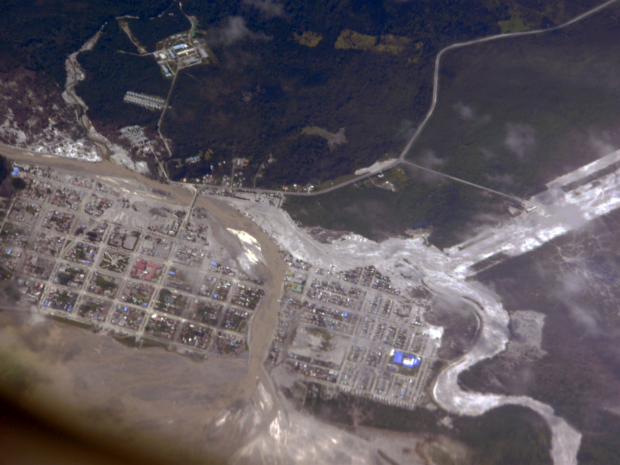
The town was completely flooded on May 12, 2008, after a lahar caused the banks of the Blanco River to overflow about 200 m on each side. Over the subsequent weeks, the river excavated a new course through Chaitén, completely destroying a significant part of it by July 2008. This process is still ongoing; it is unclear how extensive the damage will ultimately be. Some defensive work has been undertaken by the government, but they ultimately decided to abandon the town, relocating and compensating all residents. The provincial capital was provisionally moved to Futaleufú after the eruption breakout, but the capital shift was later on declared permanent. The future of the town has become a matter of political controversy in Chile.
Reconstruction of Chaitén
On February 25, 2009, the government announced plans to rebuild Chaitén 10 km north of its current location in a coastal place known as Santa Bárbara or "Fandango Norte". On March 3, 2009, construction work on the new town's administrative facilities started.
On April 9, 2011, president Sebastián Piñera announced a program to rebuild the town on its existing northern area, reversing plans by the previous administration to move the town to a different location farther north.
Climate
|Jan record high C = 29.0 |Feb record high C = 31.4 |Mar record high C = 27.6 |Apr record high C = 23.2 |May record high C = 22.0 |Jun record high C = 17.0 |Jul record high C = 21.2 |Aug record high C = 19.2 |Sep record high C = 23.6 |Oct record high C = 24.8 |Nov record high C = 27.0 |Dec record high C = 28.0 |Jan record low C = 0.7 |Feb record low C = 3.0 |Mar record low C = 0.1 |Apr record low C = -1.2 |May record low C = -2.2 |Jun record low C = -3.6 |Jul record low C = -3.6 |Aug record low C = -2.7 |Sep record low C = -2.6 |Oct record low C = -1.0 |Nov record low C = 0.6 |Dec record low C = 0.0 |access-date = 27 May 2024 |archive-url = https://web.archive.org/web/20160303180012/http://164.77.222.61/climatologia/publicaciones/Estadistica_ClimatologicaII.pdf |archive-date = 2016-03-03 |url-status = dead
Nearby attractions
Nearby attractions include:
- Corcovado National Park, which includes Corcovado volcano
- Pumalín Park, which includes Michinmahuida volcano
- Yelcho Lake
- Carretera Austral
- Futaleufu River
References
References
- "Chile Time". WorldTimeZones.org.
- "Chile Summer Time". WorldTimeZones.org.
- link. (May 10, 2008 ))
- [https://web.archive.org/web/20080511203132/http://www.timesonline.co.uk/tol/news/environment/article3883087.ece (''Times'' online) "4,000 evacuated as volcano blast meets storm in the Chilean sky"] May 6, 2008.
- [http://modis.gsfc.nasa.gov/gallery/individual.php?db_date=2008-05-07 NASA, "Earth Observatory Natural Hazards] plume visible from space]
- Lange, D.. (April 2008). "First seismic record for intra-arc strike-slip tectonics along the Liquiñe-Ofqui fault zone at the obliquely convergent plate margin of the southern Andes". Tectonophysics.
- Chaitén. SI / USGS Weekly Volcanic Activity Reports]
- "La Nacion "Gobierno no reconstruirá Chaitén y prepara relocalización", 2009 Jan 30".
- [http://diario.elmercurio.com/2009/02/26/nacional/nacional/noticias/9B9D95FC-E45A-4ED1-9A23-47CC95C6A148.htm ] {{webarchive. link. (March 1, 2009)
- (2010-02-25). "Comienzan los trabajos para la construcción de centro cívico de nueva Chaitén". Latercera.com.
- [http://www.emol.com/noticias/nacional/2011/04/09/475139/pinera-oficializa-refundacion-de-chaiten-en-sector-norte-de-la-ciudad.html Piñera oficializa refundación de Chaitén en sector norte de la ciudad], El Mercurio, April 9, 2011.
This article was imported from Wikipedia and is available under the Creative Commons Attribution-ShareAlike 4.0 License. Content has been adapted to SurfDoc format. Original contributors can be found on the article history page.
Ask Mako anything about Chaitén — get instant answers, deeper analysis, and related topics.
Research with MakoFree with your Surf account
Create a free account to save articles, ask Mako questions, and organize your research.
Sign up freeThis content may have been generated or modified by AI. CloudSurf Software LLC is not responsible for the accuracy, completeness, or reliability of AI-generated content. Always verify important information from primary sources.
Report