From Surf Wiki (app.surf) — the open knowledge base
Brassó County
County of the Kingdom of Hungary

County of the Kingdom of Hungary
| Field | Value |
|---|---|
| native_name | |
| conventional_long_name | Brassó County |
| common_name | Brassó |
| subdivision | County |
| nation | the Kingdom of Hungary |
| year_start | 1876 |
| event_end | Treaty of Trianon |
| year_end | 1920 |
| date_end | June 4 |
| image_coat | Coa_Hungary_County_Brassó_(history).svg |
| image_map | Brassó vármegye Magyarországon.svg |
| capital | Brassó |
| coordinates | |
| stat_area1 | 1492 |
| stat_pop1 | 101109 |
| stat_year1 | 1910 |
| today | Romania |
| footnotes | Brașov is the current name of the capital. |
Brassó was an administrative county (comitatus) of the Kingdom of Hungary. Its territory is now in central Romania (south-eastern Transylvania). The capital of the county was Brassó (Brașov in Romanian, Kronstadt in German).
Geography
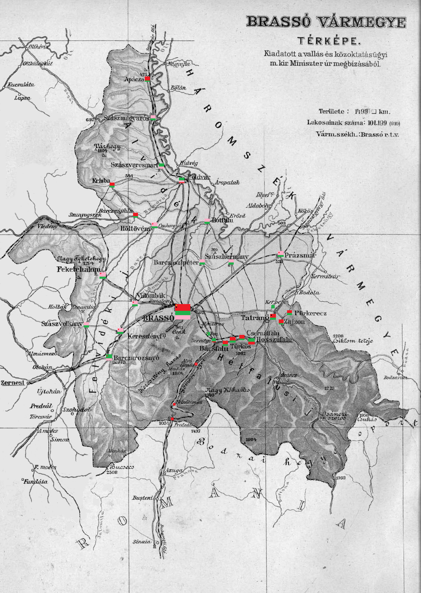
Brassó County shared borders with Romania and the Hungarian counties of Fogaras, Nagy-Küküllő, and Háromszék. The river Olt formed part of its northern border. The ridge of the Southern Carpathian Mountains forms its southern border. Its area was 1492 km2 around 1910.
History
The Brassó/Kronstadt region was settled by German colonists since the 12th century. Brassó County was formed in 1876, when the administrative structure of Transylvania was changed, and was centered on the former Saxon seat of Kronstadt/Brașov. In 1920, by the Treaty of Trianon, the county became part of Romania. Its territory lies in the present Romanian county of Brașov.
Demographics
| Census | Total | Hungarian | Romanian | German | Other or unknown | 1880 | 1890 | 1900 | 1910 |
|---|---|---|---|---|---|---|---|---|---|
| 83,929 | 23,948 (29.62%) | 29,250 (36.18%) | 26,579 (32.87%) | 1,074 (1.33%) | |||||
| 86,777 | 26,116 (30.10%) | 31,106 (35.85%) | 27,802 (32.04%) | 1,753 (2.02%) | |||||
| 95,565 | 31,191 (32.64%) | 33,886 (35.46%) | 29,415 (30.78%) | 1,073 (1.12%) | |||||
| 101,199 | 35,372 (34.95%) | 35,091 (34.68%) | 29,542 (29.19%) | 1,194 (1.18%) |
| Census | Total | Lutheran | Eastern Orthodox | Roman Catholic | Calvinist | Jewish | Unitarian | Greek Catholic | Other or unknown | 1880 | 1890 | 1900 | 1910 |
|---|---|---|---|---|---|---|---|---|---|---|---|---|---|
| 83,929 | 39,407 (46.95%) | 31,206 (37.18%) | 8,541 (10.18%) | 3,228 (3.85%) | 679 (0.81%) | 466 (0.56%) | 356 (0.42%) | 46 (0.05%) | |||||
| 86,777 | 39,905 (45.99%) | 31,579 (36.39%) | 9,837 (11.34%) | 3,489 (4.02%) | 868 (1.00%) | 521 (0.60%) | 561 (0.65%) | 17 (0.02%) | |||||
| 95,565 | 42,082 (44.03%) | 33,901 (35.47%) | 10,675 (11.17%) | 5,484 (5.74%) | 1,291 (1.35%) | 1,030 (1.08%) | 1,075 (1.12%) | 27 (0.03%) | |||||
| 101,199 | 42,901 (42.39%) | 35,585 (35.16%) | 11,886 (11.75%) | 6,854 (6.77%) | 1,503 (1.49%) | 1,441 (1.42%) | 979 (0.97%) | 50 (0.05%) |
Subdivisions

In the early 20th century, the subdivisions of Brassó County were:
| Districts (járás) | District | Capital | Urban districts (rendezett tanácsú város) |
|---|---|---|---|
| Alvidék | Földvár (now Feldioara) | ||
| Felvidék | Feketehalom (now Codlea) until 1894, then Brassó (now Brașov) | ||
| Hétfalu | Hosszúfalu (now Săcele) | ||
| Brassó (now Brașov) |
Notes
References
References
- "Az 1881. év elején végrehajtott népszámlálás főbb eredményei megyék és községek szerint rendezve, II. kötet (1882)". library.hungaricana.hu.
- "A Magyar Korona országainak helységnévtára (1892)". library.hungaricana.hu.
- "A MAGYAR KORONA ORSZÁGAINAK 1900". library.hungaricana.hu.
- "KlimoTheca :: Könyvtár". Kt.lib.pte.hu.
This article was imported from Wikipedia and is available under the Creative Commons Attribution-ShareAlike 4.0 License. Content has been adapted to SurfDoc format. Original contributors can be found on the article history page.
Ask Mako anything about Brassó County — get instant answers, deeper analysis, and related topics.
Research with MakoFree with your Surf account
Create a free account to save articles, ask Mako questions, and organize your research.
Sign up freeThis content may have been generated or modified by AI. CloudSurf Software LLC is not responsible for the accuracy, completeness, or reliability of AI-generated content. Always verify important information from primary sources.
Report